This content was originally published by the Longmont Observer and is licensed under a Creative Commons license.
In Brief:
Another above average day will play out today before our much anticipated cold front hits around 5-6pm (in Longmont). Skies will cloud up and freezing drizzle will form pretty quickly changing to light snow about midnight. We should see 1/2 to 2 inches of snow around town by noon Monday. Skies should clear in the afternoon and we'll see things start to melt in the sun Monday even with a below freezing high. We return to a normal and dry week beyond Monday. The transit of Venus across the Sun I've invited you to view is unlikely to be visible from NE Colorado as the storm will still be in progress.
8:30 am update:
It looks like we received just about 2 inches of snow (better: 1.7") by 7am this morning. The coating of ice and snow has frozen my observatory dome closed. The motor is not strong enough to open it, so viewing the Transit of Mercury is off at Cherrywood Observatory. A live feed from Flagstaff AZ is visible here though. Enjoy:
End 8:30am update.
Forecast Discussion:
Let's start with the National Weather Service again:
Hazardous Weather Outlook
National Weather Service Denver/Boulder CO
1101 AM MST Sun Nov 10 2019

COZ030>051-111815-
Jackson County Below 9000 Feet-
West Jackson and West Grand Counties Above 9000 Feet-
Grand and Summit Counties Below 9000 Feet-
South and East Jackson/Larimer/North and Northeast Grand/
Northwest Boulder Counties Above 9000 Feet-
South and Southeast Grand/West Central and Southwest Boulder/
Gilpin/Clear Creek/Summit/North and West Park Counties Above
9000 Feet-Larimer and Boulder Counties Between 6000 and 9000 Feet-
Jefferson and West Douglas Counties Above 6000 Feet/Gilpin/Clear
Creek/Northeast Park Counties Below 9000 Feet-
Central and Southeast Park County-
Larimer County Below 6000 Feet/Northwest Weld County-
Boulder And Jefferson Counties Below 6000 Feet/West Broomfield
County-
North Douglas County Below 6000 Feet/Denver/West Adams and
Arapahoe Counties/East Broomfield County-
Elbert/Central and East Douglas Counties Above 6000 Feet-
Northeast Weld County-Central and South Weld County-Morgan County-
Central and East Adams and Arapahoe Counties-
North and Northeast Elbert County Below 6000 Feet/North Lincoln
County-
Southeast Elbert County Below 6000 Feet/South Lincoln County-
Logan County-Washington County-Sedgwick County-Phillips County-
1101 AM MST Sun Nov 10 2019

This hazardous weather outlook is for northeast and north central
Colorado.

.DAY ONE...Today and Tonight

Warm and dry conditions will be replaced by much colder
temperatures and a return to wintry precipitation tonight. The
much colder temperatures will arrive behind a cold front this
evening, with a mixture of light freezing drizzle and snow
developing from north to south across the forecast area this
evening. Precipitation will first begin near the Wyoming and
Nebraska borders by 8 to 9 PM, and then spread southward into the
I-70 Corridor toward midnight. Total snow accumulations are
expected to range between 1 and 3 inches along and north of I-70
in the mountains and I-76 on the Plains, with an inch or less
farther south.

Roads are expected to turn icy and snow covered as temperatures
drop into the 15 to 20 degree range late tonight. Travelers late
tonight into the Monday morning commute should be prepared for
hazardous travel conditions and longer than normal commute times.

.DAYS TWO THROUGH SEVEN...Monday through Saturday

Areas of light snow will be coming to an end Monday morning, but
cold temperatures will remain. Afternoon temperatures will remain
below freezing all day. Areas of fog will be possible across the
plains Monday night and Tuesday morning which may affect the
morning commute. Warmer temperatures are expected through the rest
of the week as a strong upper level ridge builds over the western
United States.

.SPOTTER INFORMATION STATEMENT...

Spotter activation will not be needed today or tonight. Any
freezing drizzle or snowfall reports will be appreciated.
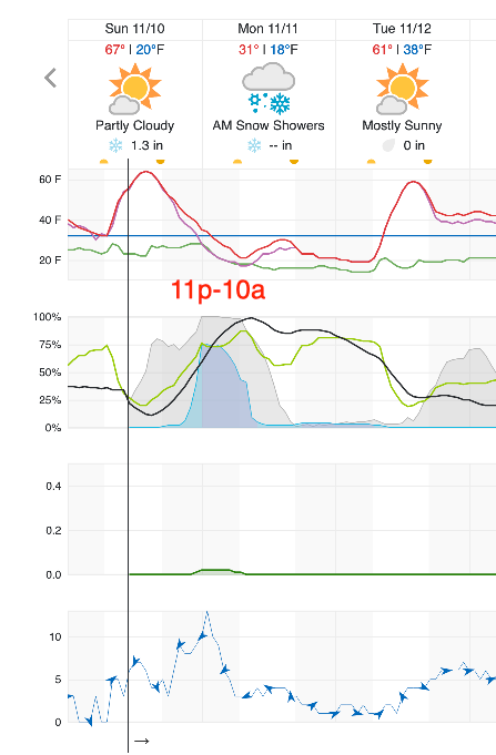
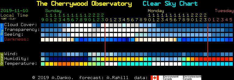
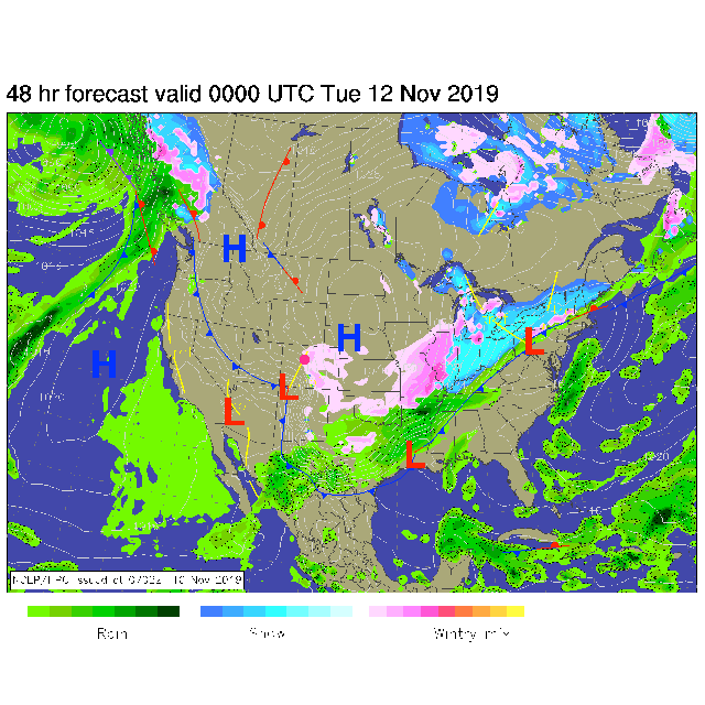
The cold front is trending a bit later and may not arrive until almost 6pm in Longmont then 7-8pm in Denver. But the cold air is catching up to the front, so sub-freezing temperatures will arrive sooner after the front passes than the previously expected (midnight) (Figure 1). Clouds will move in quickly as well (Figure 2 and 3). Drizzle should begin to fall around 7-8pm and will become freezing drizzle shortly after that. The precipitation should change to snow around 11p-12a and Longmont is still in the 1/2-2 inch zone for snow by noon Monday.
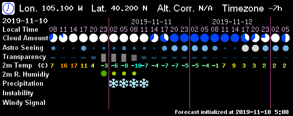
The slower overall trend will have clouds and snow occurring later into the morning Monday which will impact the morning commute with slick conditions and cold air (Figure 4 and Figure 5).
Snowfall Roundup:
Weatherunderground shows 1.3 inches of snow (Figure 1).
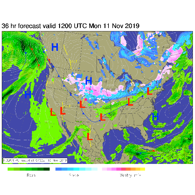
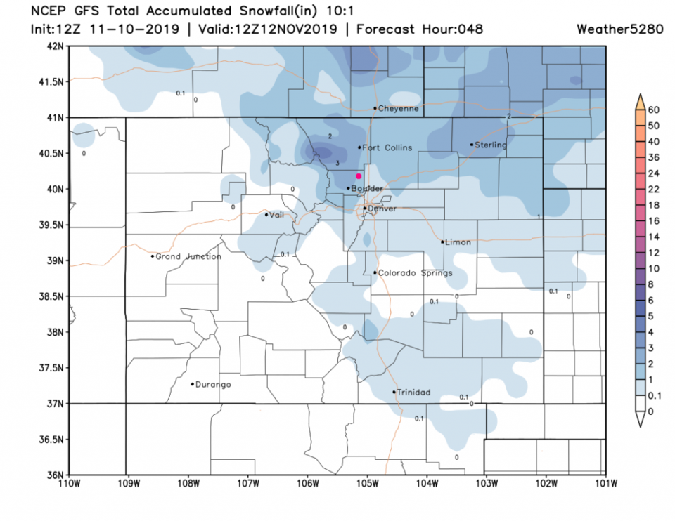
The GFS shows 1-2 inches (Figure 6).
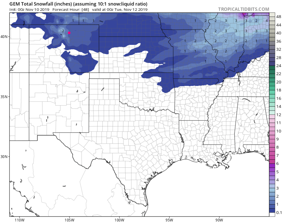
The GEM shows 1/2 to 1 inch (Figure 7).
The Longer Range Forecast:
Things rapidly return to normal (50'sF) and get dry for a few days. More next time!
Mercury Transit:
You are still invited to the Cherrywood Observatory between 7am and 11:04am, but it looks like the clouds will be thick and the skies snowing for this transit (Figure 2 and 3). The next one will be November 13, 2032. Ok, so that will be a bit of a wait. Text me at 720-378-2771 if you need directions of confirmation of cancellation.