Skip to content

Next Storm/Next Snow Forecast Discussion from the Cherrywood Observatory – November 12-14, 2019

This content was originally published by the Longmont Observer and is licensed under a Creative Commons license.

In Brief:

We spend the next (almost) 5 days a bit warmer than normal and mostly dry (with a few cloudy days). A front arrives Saturday for a chance of rain (snow?) and another front does the same next Tuesday. We'll watch those for signs of further development this week.

Forecast Discussion:

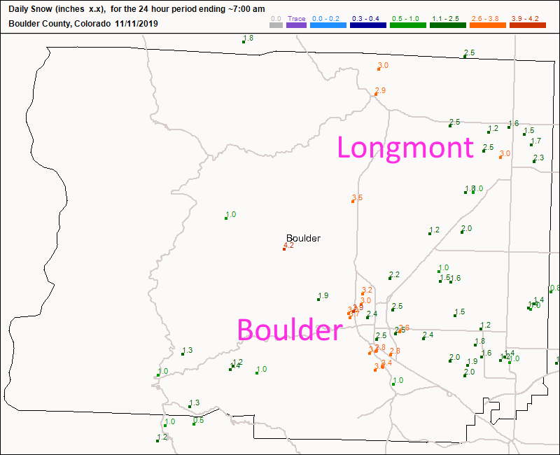
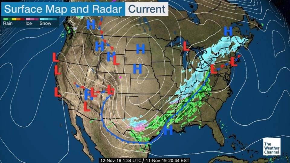
The forecast for last nights storm came out well. A pretty notable layer of ice got laid down before 1-3 inches of snow fell across Longmont (Figure 1). Boulder did better (like normal) with 2-4 inches. Our storm has blasted all the way down to Texas giving us clear skies and warming temperatures as the western ridge returns Tuesday (Figure 2).

The Longer Range Forecast:

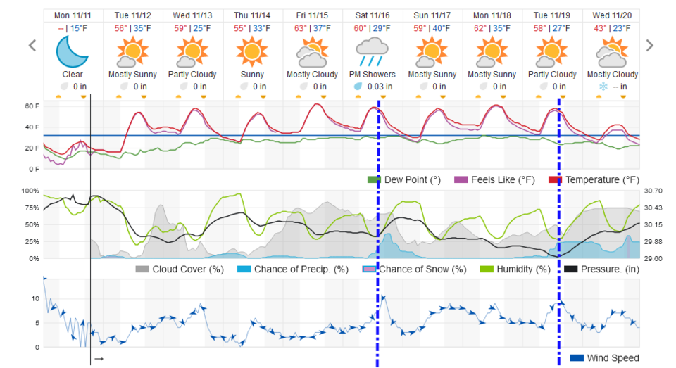
That's the story through Saturday - a bit warmer than normal and dry. There is a hint of a Saturday cold front with rain/snow and another front on Tuesday for more rain/snow (Figure 3). It's sort of boring again, so let's look at the last long range forecast (as promised) and the next even longer range forecast...

The Ultra Long Range Forecast:

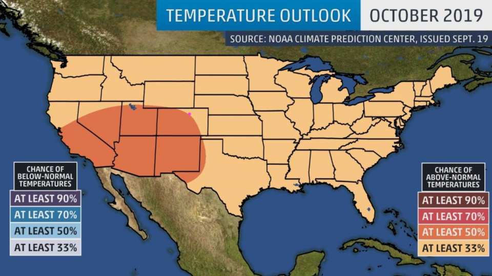
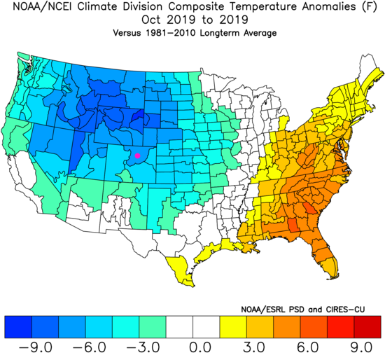
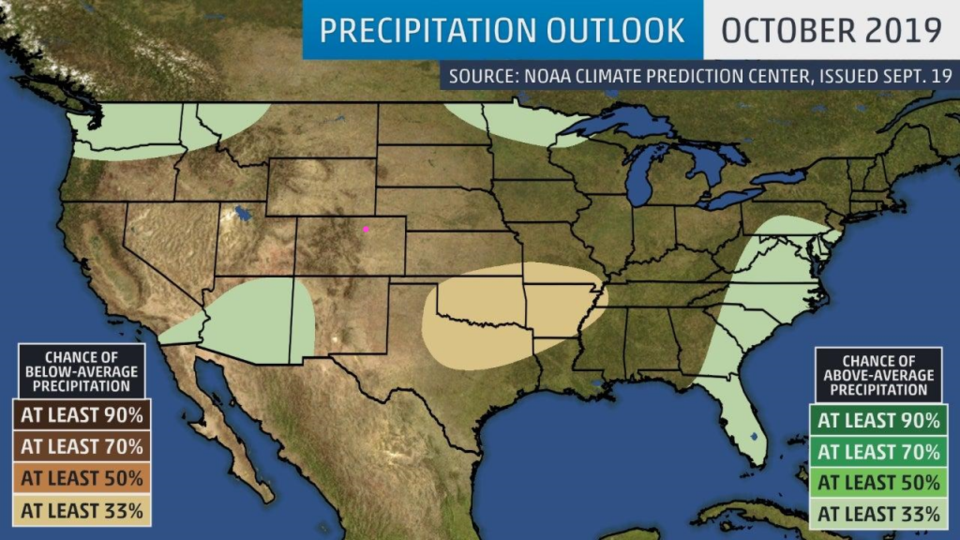
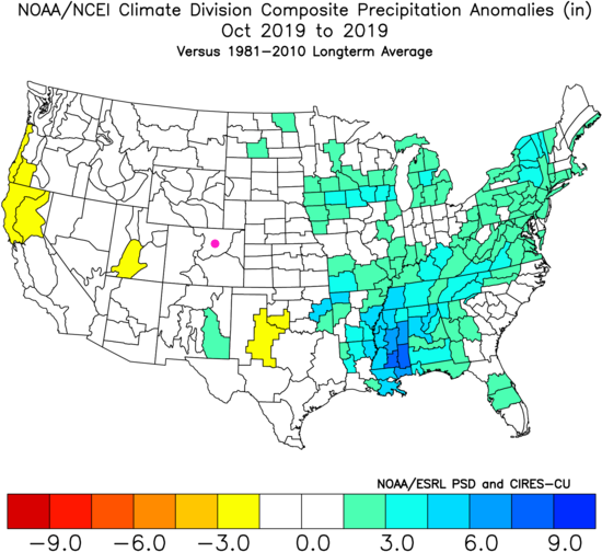
At the start of October, the NOAA outlook was for above normal temperatures here (Figure 4). What happened was nearly the opposite (Figure 5). The NOAA precipitation forecast was somewhat spotty and was for normal amounts around Colorado (Figure 6). What occurred was near normal precipitation around here (but most of it came as snow, which was above normal) (Figure 7). The NOAA forecast busted as far as temperature trends went.

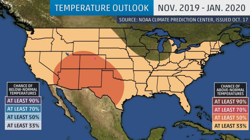
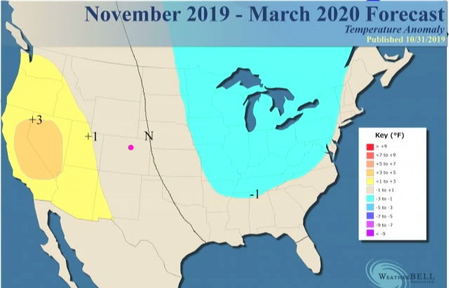
The NOAA forecast for November-January is for above normal temperatures (Figure 8). Weatherbell has an outlook that gives us near normal temperatures and massive cold in the upper Midwest (Figure 9). Weatherbell did much better for October (not shown).

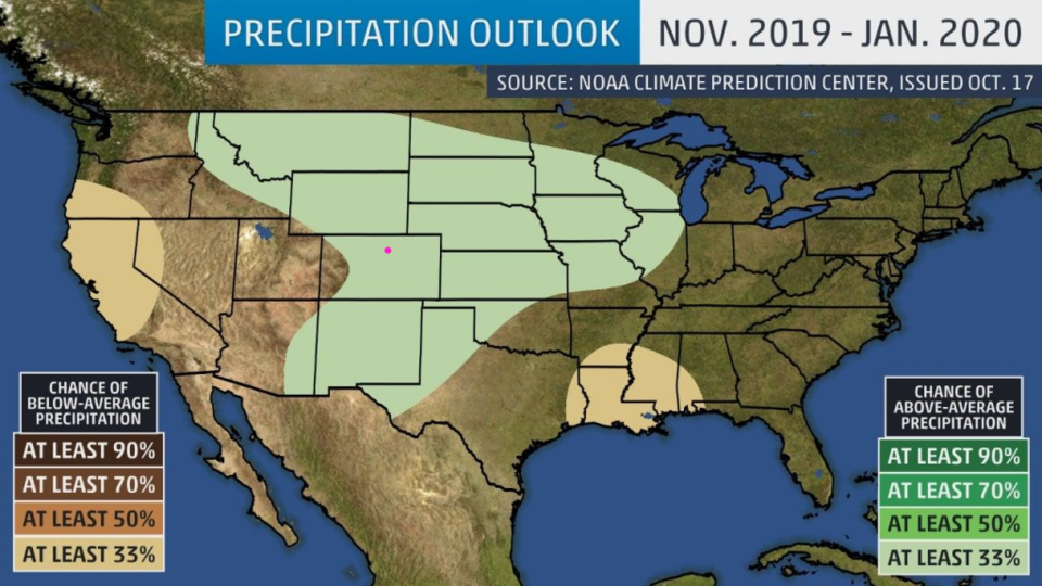
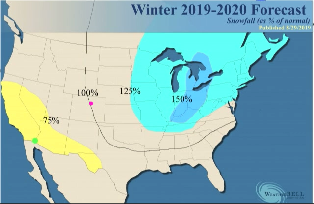
As precipitation goes, NOAA has us wetter than normal (Figure 10) while Weatherbell paints us as near normal (snowfall-wise Figure 11). I might lean towards Weatherbell personally with the record of October to look back on - very close to normal snowfall and temperatures for the rest of the winter.

Figure 1: 24 hour snowfall reports through 7am Monday in Boulder Co. from CoCoRaHS.
Figure 2: The current surface analysis map from the Weather Channel Monday night.
Figure 3: the graphical forecast for the next 10 days for Longmont, CO from weatherunderground.com
Figure 4: The temperature outlook for October 2019 made in the end of September and posted in this column from NOAA.
Figure 5: The actual temperature anomaly that occurred October 2019 from NOAA/NCEI Climate Division.
Figure 6: The precipitation outlook for October 2019 made in the end of September and posted in this column from NOAA.
Figure 7: The actual precipitation anomaly that occurred October 2019 from NOAA/NCEI Climate Division.
Figure 8: The temperature outlook for Nov 2019 to Jan 2020 made in the end of October from NOAA.
Figure 9: The Nov 2019-March 2020 temperature forecast from WeatherBell screen capture from their free online video.
Figure 10: The temperature outlook for Nov 2019 to Jan 2020 made in the end of October from NOAA.
Figure 11: The Nov 2019-March 2020 snowfall forecast from WeatherBell screen capture from their free online video.

Current Weather

Mostly cloudy

Mostly cloudy

62°F

UV Index
1 Low
Pressure
29.65 Rising
Visibility
7 miles
Dewpoint
38 °F
Humidity
42%
Wind
NE 5.7 mph
Gust
10.7 mph
Wind Chill
62 °F

Hourly Forecast

Today
7 PM
60°F
Thunderstorms
Today
8 PM
56°F
Cloudy
Today
9 PM
52°F
Cloudy
Today
10 PM
50°F
Thunderstorms
Today
11 PM
48°F
Thunderstorms
Tomorrow
12 AM
46°F
Cloudy
Tomorrow
1 AM
46°F
Cloudy
Tomorrow
2 AM
45°F
Cloudy
Tomorrow
3 AM
44°F
Rain
Tomorrow
4 AM
44°F
Cloudy
Tomorrow
5 AM
44°F
Rain
Tomorrow
6 AM
44°F
Rain

7 Day Forecast

Mostly cloudy w/ t-storms

Friday

69 °F

Variable cloudiness with a couple of thundershowers this afternoon; gusty winds and small hail can accompany any downpour


Thunderstorms

Friday Night

41 °F

Cloudy; a couple of showers and a thunderstorm this evening followed by periods of rain late; gusty winds and small hail can accompany any downpour


Rain

Saturday

44 °F

Chilly with periods of rain and a thunderstorm; travel in the foothills and mountains will be slippery due to snow


Rain and snow

Saturday Night

36 °F

Cloudy with rain, mixed with a little snow late; travel in the foothills and mountains will be slippery due to snow


Mostly cloudy

Sunday

61 °F

Mostly cloudy and warmer


Intermittent clouds

Sunday Night

36 °F

A thunderstorm in spots in the evening; otherwise, partly cloudy


Partly sunny

Monday

71 °F

Partly sunny, pleasant and warmer


Partly cloudy

Monday Night

45 °F

Partly cloudy


Mostly sunny

Tuesday

73 °F

Pleasant with sunshine and patchy clouds


Partly cloudy

Tuesday Night

40 °F

Partly cloudy


Sunrise and Sunset

Sunrise
6:06 AM
Sunset
7:51 PM

Based on AccuWeather data