This content was originally published by the Longmont Observer and is licensed under a Creative Commons license.
In Brief:
The winds are blowing out of the northeast already (Wednesday 4:30pm) and the cold air, some snow, and cold air is on the way (yes, lots of cold air). Rain/drizzle may form around 9pm and the snow should start to fall between midnight and 3am. We approach 10F Friday AM then rebound almost to 50F Friday afternoon. Things are mild and beautiful for the weekend and next week.
Forecast Discussion:
Let's start with the official advisory and warning:
NWS: Winter Weather Advisory
Alert brief: Winter Weather Advisory issued October 9 at 3:59PM MDT until October 10 at 6:00PM MDT by NWS Denver CO...SEASON'S FIRST SHOT OF WINTER COMING IN FAST WITH COLD AND SNOW...
A powerful storm system moving across Wyoming will push a very strong cold front across the plains early this evening. Temperatures will drop sharply, and result in winter precipitation and possible hazardous travel conditions. Snow will first start in the northern mountains and northern border area late this evening, and then spread southward to the I-70 Corridor and rest of the plains overnight. Precipitation may begin as light drizzle and freezing drizzle on the plains, before switching over to all snow by Thursday morning. The Thursday morning commute looks snowy in most areas. Snow may accumulate on road surfaces even in lower elevations, with bridges and overpasses most susceptible to icing. Please allow extra time to travel in the season's first snowfall.
* WHAT...Light drizzle and freezing drizzle changing to all snow from north to south overnight. Snow will likely be heaviest during the Thursday morning commute. Total snow accumulations of 1 to 3 inches, with up to 6 inches in the foothills.
* WHERE...The Front Range Foothills, and I-25 Urban Corridor.
* WHEN...From 10 PM this evening to 6 PM MDT Thursday.
* IMPACTS...Plan on slippery road conditions. The hazardous conditions could impact the Thursday morning commute.
* ADDITIONAL DETAILS...This will also be a hard freeze, so drain above ground sprinkler systems before tonight. Some tree damage is possible in areas that see more than 2-3 inches of snow.
NWS: Freeze Warning
Alert brief: Freeze Warning issued October 9 at 4:18AM MDT until October 10 at 9:00AM MDT by NWS Denver CO
* WHAT...Sub-freezing temperatures as low as 20 expected.
* WHERE...Northeast and East Central Colorado, including the Denver Metro area.
* WHEN...Freezing temperatures as early as 10 PM Wednesday.
* IMPACTS...Frost and freeze conditions will kill crops, other sensitive vegetation and damage unprotected outdoor plumbing.
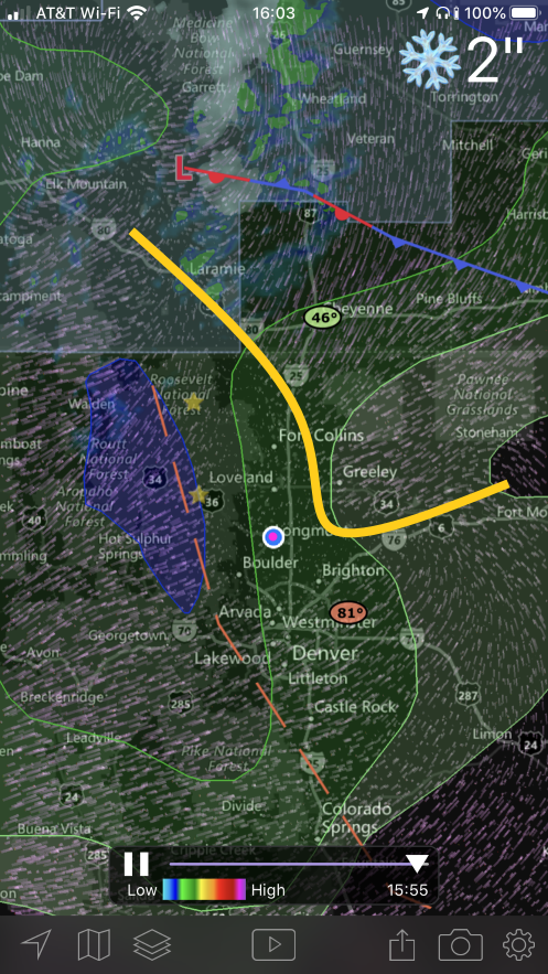
Now to the discussion: The yellow line in Figure 1 if the wind shift line sweeping in. The NWS has the front (and colder air) up in Wyoming and Nebraska as it sweeps down as well.
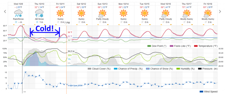
We should see drizzle and freezing drizzle starting before midnight with snow beginning around midnight or as late as 3am (Figure 2).
Snowfall Roundup:
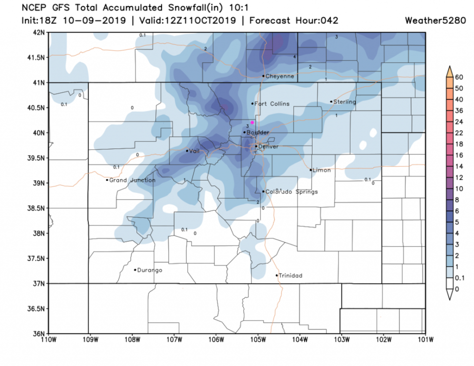
The GFS (Figure 3) gives us 1-2 inches of snow.
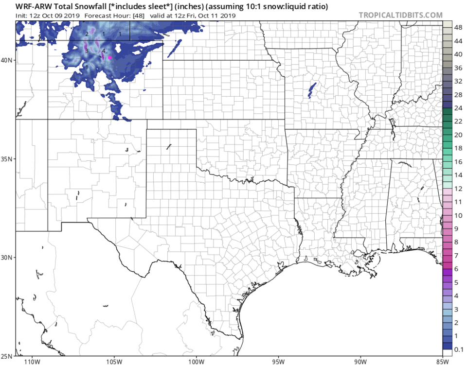
The WRF (Figure 4) gives us 1.5-2.5 inches of snow.
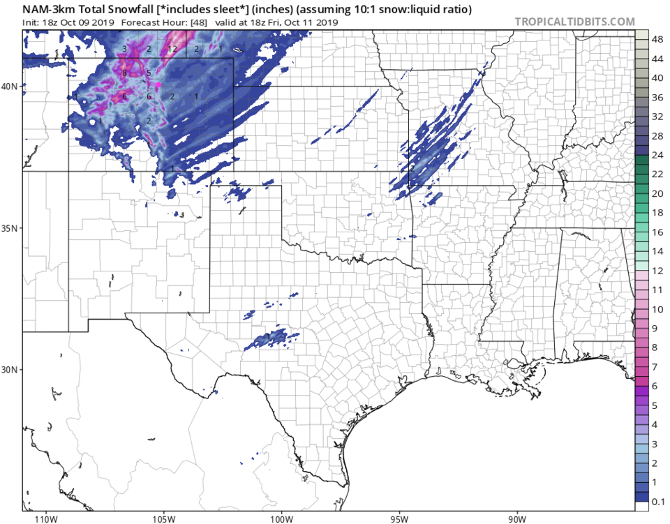
The NAM (Figure 5) is heavier now at 2-4 inches of snow.
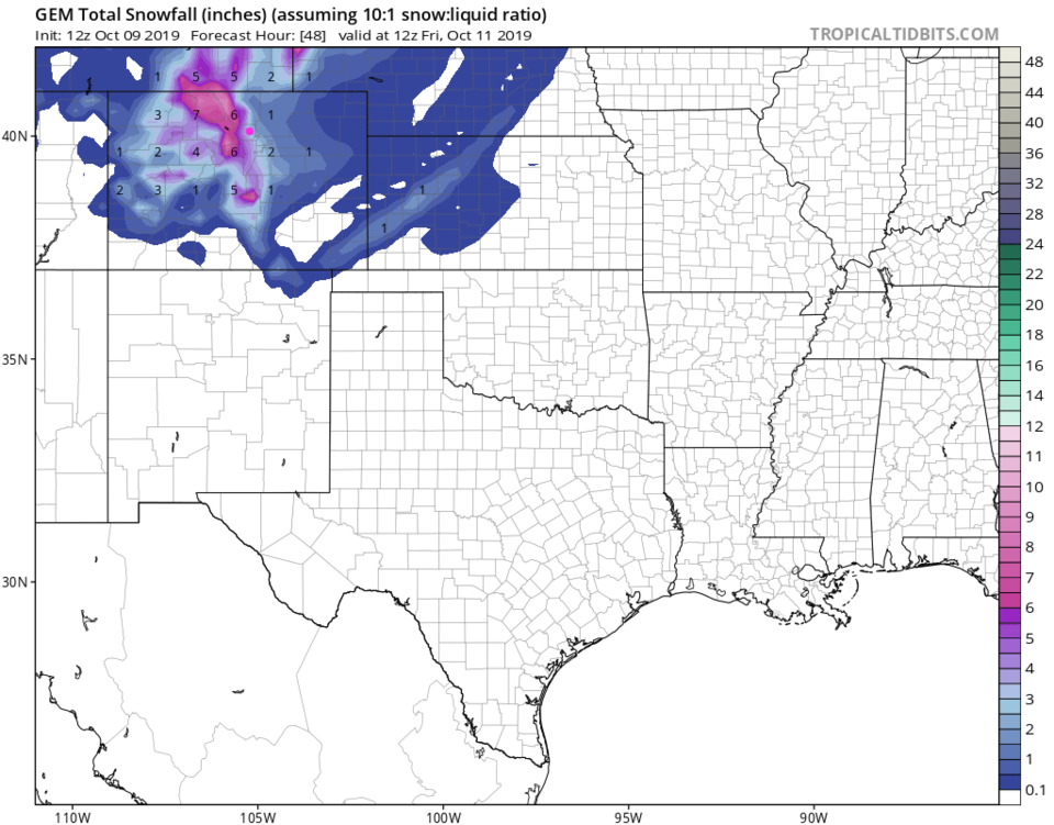
The GEM (Figure 6) is heaver as well at 2-4 inches of snow.
Weatherunderground (Figure 2) gives us 1-2 inches of snow.
The NWS in the advisory above is listed as 1-3 inches of snow.
My call for Longmont is 1.5-2.5 inches of snow - mainly on colder/grassy surfaces. A snow band parking over a community could double these snowfall amounts (see the streak-y pattern in all the snow graphics below).
All the cold air, and dangers and difficulties of air in the lower teens, are still on their way. We are not accustomed to air like this. Bundle up!
I am hopeful, I called for 1 inch of snow at DIA for 10/10 in the forecasting contest listed in this column (run by weathe5280.com) back in the last week of September. I have my fingers crossed!
The Longer Range Forecast:
We are back above freezing Friday afternoon and enjoying Fall weather - dry and cool - all week. That's all I have to say about that.