Skip to content

Update 10/13 3pm: Next Storm/Next Snow Forecast Discussion from the Cherrywood Observatory – October 13-15, 2019

This content was originally published by the Longmont Observer and is licensed under a Creative Commons license.

In Brief:

Very nice mild weather weather is the story for this upcoming week. A trough will pass Tuesday and kick up some winds and cool us down, but we recover to the 70'sF until the weekend. A chance of rain (and snow?) return at the start of next week.

Update 10/13 3pm:

It is too beautiful out there to stay inside at the computer long, but the snow for Sunday/Monday 10/20-21 is looking like it might be a bigger deal. This is your heads up for next weekend.

Figure 1 update: The forecast snowfall totals for the next 10 days from the GFS and weather5280com for Colorado made Saturday morning.

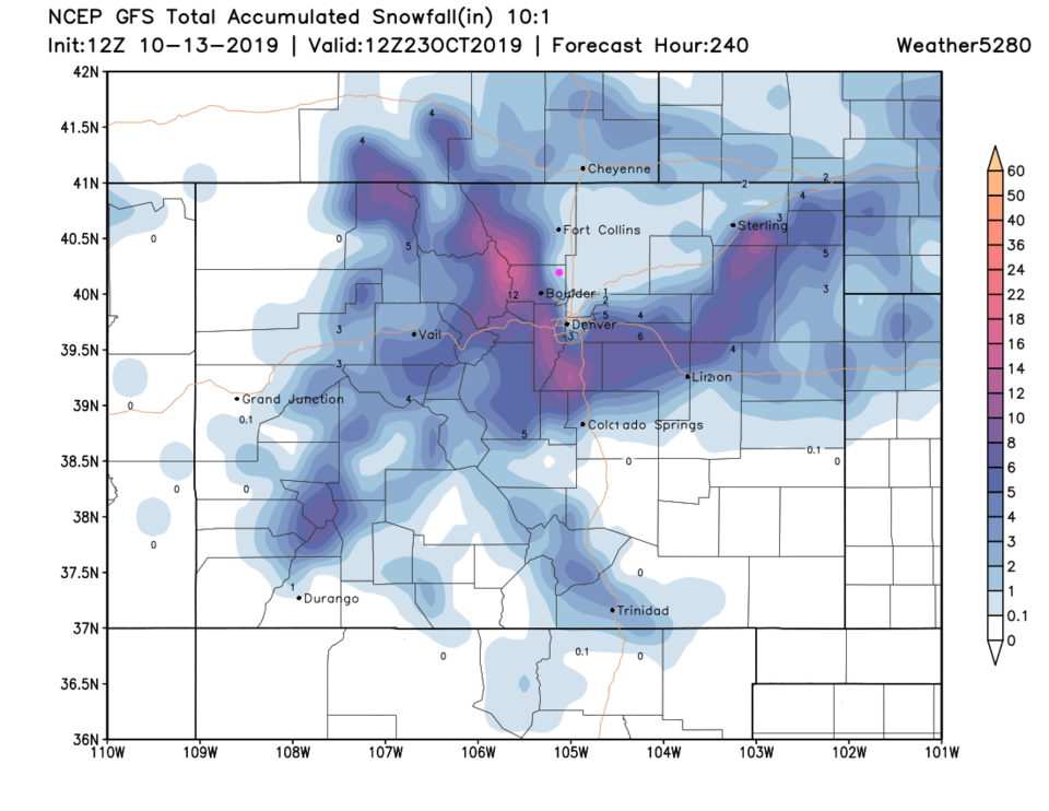
End update 10/13 3pm.

Forecast Discussion:

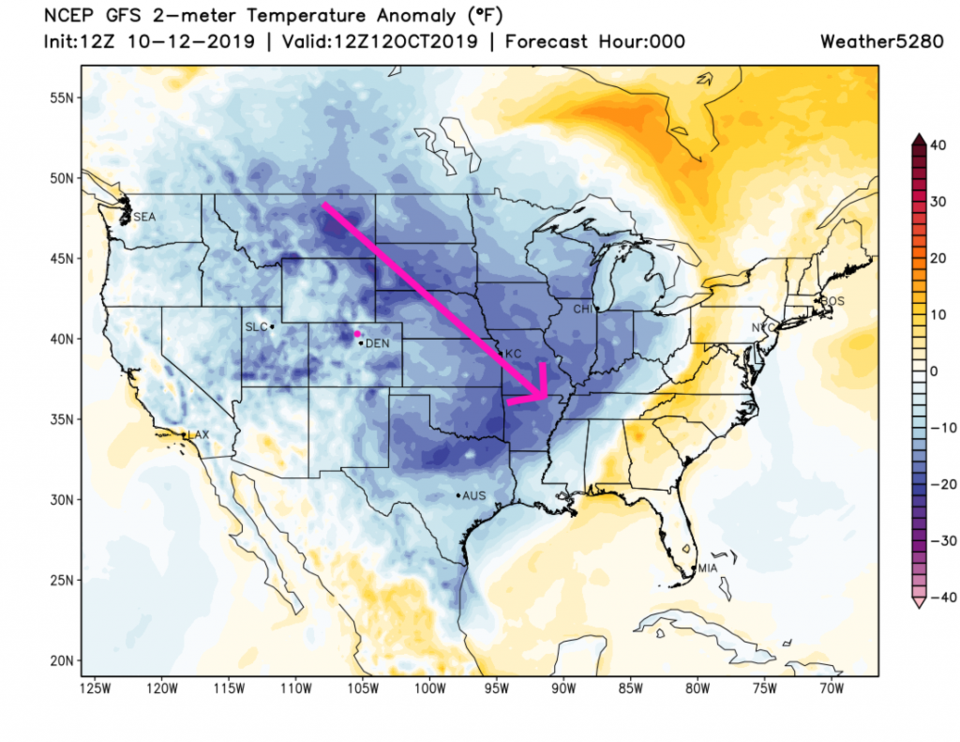
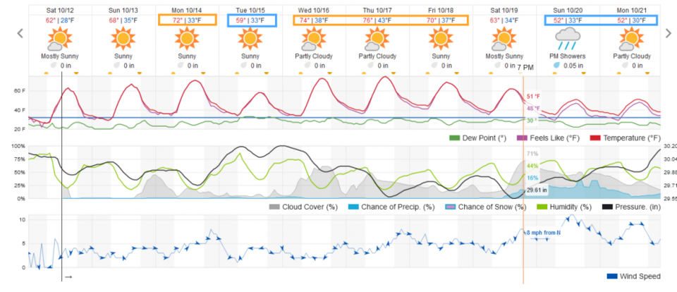
The cold front continues plow across the nation this weekend as we begin our warm-up. Dry and warmer conditions is the simple story for this long weekend (Figure 1). We'll even see 70'sF Monday (Figure 2).

The Longer Range Forecast:

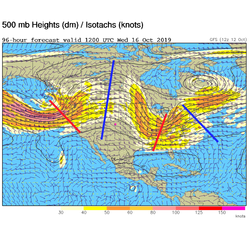
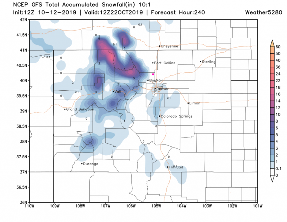
A passing upper level trough cools us about 10 degrees Tuesday with a windy morning (not shown). Little precipitation is expected. We bounce back to the 70'sF for the rest of the week (Figure 2). This warmth is created by a ridge as it drifts over the state (Figure 3). There is indication of a return of cool wet weather next Sunday (Figure 2) with snow up in the mountains (some runs give us a bit of snow as well - Figure 4).

Figure 1: the surface temperature anomaly (departure from normal) from the GFS for Saturdamorning from weather5280.com.
Figure 2: the graphical forecast for the next 10 days for Longmont, CO from weatherunderground.com
Figure 3: The 500mb forecast upper air analysis for Wednesday AM. Pink dot is Longmont. Red lines are troughs, blue lines are ridges.
Figure 4: The forecast snowfall totals for the next 10 days from the GFS and weather5280com for Colorado made Saturday morning.

Current Weather

Mostly clear

Mostly clear

34°F

UV Index
0 Low
Pressure
29.99 Steady
Visibility
8 miles
Dewpoint
24 °F
Humidity
66%
Wind
WNW 2.2 mph
Gust
4.8 mph
Wind Chill
34 °F

Hourly Forecast

Today
3 AM
31°F
Partly cloudy
Today
4 AM
30°F
Intermittent clouds
Today
5 AM
28°F
Intermittent clouds
Today
6 AM
26°F
Mostly cloudy
Today
7 AM
29°F
Mostly cloudy
Today
8 AM
36°F
Partly sunny
Today
9 AM
42°F
Partly sunny
Today
10 AM
48°F
Partly sunny
Today
11 AM
53°F
Partly sunny
Today
12 PM
57°F
Partly sunny
Today
1 PM
60°F
Partly sunny
Today
2 PM
62°F
Partly sunny

7 Day Forecast

Mostly sunny

Wednesday

54 °F

Sunny to partly cloudy and warmer


Mostly cloudy

Wednesday Night

26 °F

Increasing cloudiness


Partly sunny

Thursday

64 °F

Partly sunny


Intermittent clouds

Thursday Night

35 °F

Partly cloudy


Partly sunny w/ showers

Friday

54 °F

Cooler with times of clouds and sun; a couple of showers late in the afternoon


Showers

Friday Night

33 °F

A couple of showers in the evening; otherwise, cloudy


Mostly cloudy

Saturday

60 °F

Mostly cloudy


Intermittent clouds

Saturday Night

36 °F

Partly cloudy


Intermittent clouds

Sunday

62 °F

Times of sun and clouds


Mostly cloudy

Sunday Night

36 °F

Becoming cloudy with a shower in spots late


Sunrise and Sunset

Sunrise
6:51 AM
Sunset
7:21 PM

Based on AccuWeather data