Skip to content

10/18 4pm Update: Next Storm/Next Snow Forecast Discussion from the Cherrywood Observatory – October 18-19, 2019

This content was originally published by the Longmont Observer and is licensed under a Creative Commons license.

In Brief:

As smoke drifts around the Front Range, a parade of cold fronts is on its way. The first cools us about 15F for Friday then the next drops us another 10F on Sunday. Chances of rain are present with both fronts, but not much should fall. Temperatures look too warm for snow. There is an 'over the horizon' storm mid-week next week. We'll see what that does later.

Update 10/18 4pm:

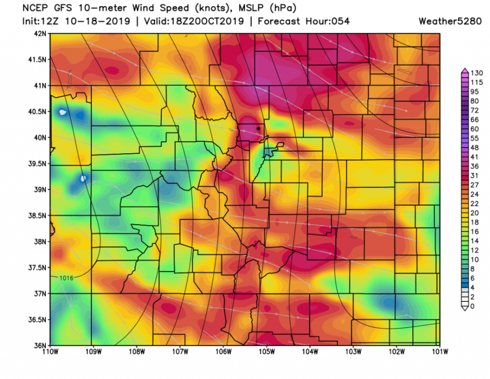
Everything is on track in the short term (in this discussion) but I do want to highlight the winds expected Sunday. Figure 1 update are the forecast winds in Colorado around noon on Sunday 10/20. That cold front is expected to be of the "Bora" variety. Definition from weatheronline.com: The bora is a cold and typically very dry and often gusty katabatic wind (fall-wind) from the north-[west*]. Bora winds can occur anytime during the year. However, the peak frequency occurs in the cold season (November - March).

*northwest for our part of the world.

Figure 1 update: the 10 m above ground level winds forecast for the 6 hours around noon on Sunday from the GFS and weather5280.com

End update 10/18 4pm.

Forecast Discussion:

There is some smoke from the Deker and Elk fires that is even dense enough to add a burning wood smell to the air in town (Figure 1). The approaching front may thin the smoke, but it will bring in smoke from other sources as well. Watch for a bit lower visibility when looking for the mountains.

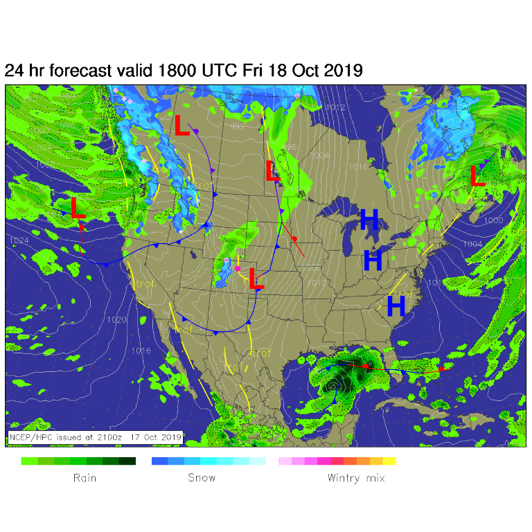
By Friday noon, the front has swept down the state (Figure 2) passing Longmont around sunrise (Figure 3). There is a small chance of post-frontal showers. We cool 15F degrees or so on Friday with breezes.

The Longer Range Forecast:

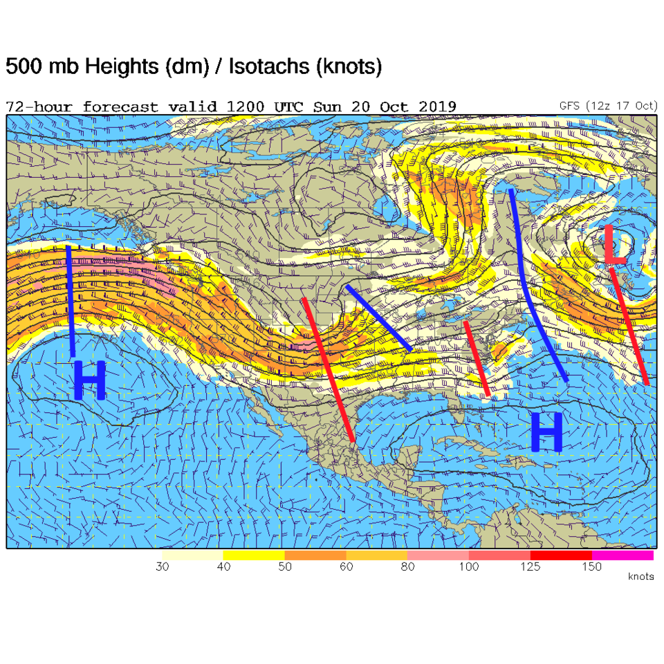
The next front hits overnight Saturday into Sunday and cools us another 10F (Figure 3). This is powered by a fairly deep, but open (not a closed circulation) trough aloft (Figure 4). It will pass quickly without a prolonged cool down or chance for snow.

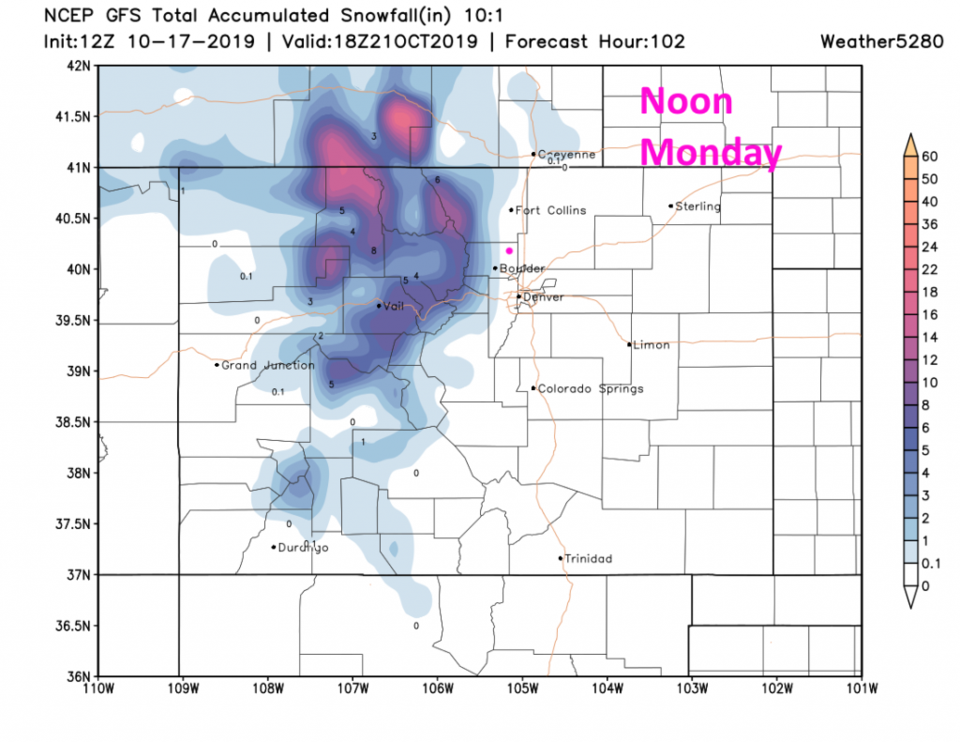
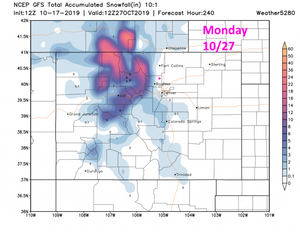
By noon Monday, the mountains will have picked up some nice snow, but Longmont seems to get skipped (even if there might be snow in the air overnight - Figure 5). You can see the next front and snow mid-week (if it comes to pass) in Figure 3. The accumulation through NEXT Monday still skips Longmont (according to the GFS). Keep rooting for snow!

Figure 1: HRRR smoke model from NOAA for the evening of 10/17.
Figure 2: The forecast surface map for Friday noon from NCEP.
Figure 3: the graphical forecast for the next 10 days for Longmont, CO from
Figure 4: The 500mb forecast upper air analysis for Sunday AM. Pink dot is Longmont. Red lines are troughs, blue lines are ridges.
Figure 5: The forecast snowfall totals for the next 4 days from the GFS and weather5280com for Colorado made Saturday morning.
Figure 6: The forecast snowfall totals for the next 10 days from the GFS and weather5280com for Colorado made Saturday morning.

Current Weather

Partly cloudy

Partly cloudy

65°F

UV Index
0 Low
Pressure
29.48 Falling
Visibility
7 miles
Dewpoint
42 °F
Humidity
42%
Wind
S 4.3 mph
Gust
9 mph
Wind Chill
65 °F

Hourly Forecast

Today
9 PM
63°F
Intermittent clouds
Today
10 PM
61°F
Mostly cloudy
Today
11 PM
59°F
Intermittent clouds
Tomorrow
12 AM
57°F
Intermittent clouds
Tomorrow
1 AM
56°F
Intermittent clouds
Tomorrow
2 AM
54°F
Mostly cloudy
Tomorrow
3 AM
53°F
Cloudy
Tomorrow
4 AM
51°F
Cloudy
Tomorrow
5 AM
50°F
Cloudy
Tomorrow
6 AM
49°F
Cloudy
Tomorrow
7 AM
47°F
Cloudy
Tomorrow
8 AM
49°F
Cloudy

7 Day Forecast

Intermittent clouds

Sunday

76 °F

Warmer with intervals of clouds and sunshine


Windy

Sunday Night

47 °F

Winds becoming strong; thickening clouds


Windy

Monday

56 °F

Winds gusting past 40 mph; cloudy and cooler


Intermittent clouds

Monday Night

42 °F

Partly cloudy


Partly sunny w/ showers

Tuesday

59 °F

A couple of showers in the morning; otherwise, windy and cool with times of clouds and sun


Partly cloudy

Tuesday Night

32 °F

Partly cloudy


Intermittent clouds

Wednesday

58 °F

Cool with times of clouds and sun


Intermittent clouds

Wednesday Night

38 °F

Partly cloudy


Intermittent clouds

Thursday

56 °F

Breezy and cool with sun and clouds


Intermittent clouds

Thursday Night

39 °F

Partly cloudy


Sunrise and Sunset

Sunrise
5:54 AM
Sunset
8:00 PM

Based on AccuWeather data