Skip to content

Next Storm/Next Snow Forecast Discussion from the Cherrywood Observatory – September 22-23, 2019

This content was originally published by the Longmont Observer and is licensed under a Creative Commons license.

In Brief:

After a chance of a late evening splash of rain and maybe a rumble of thunder, we remain mostly dry for the next 10 days with above normal temperatures (but not really hot either). Quiet is the word of the day.

Forecast Discussion:

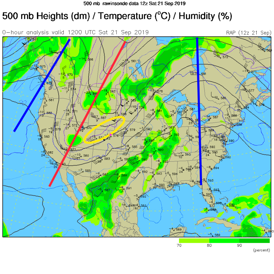
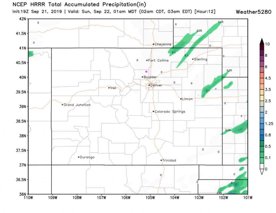
The upper air map shows a big trough to the west, but dry air dominates the state (Figure 1). A pinch in the isopleths (black lines) show a wind speed maximum approaching tonight (yellow oval). That "jet streak" acts like a vacuum cleaner and lifts the air a bit. Some showers are possible zipping across the northern parts of the state tonight. The HRRR is unimpressed by rainfall amounts (Figure 2) while the weatherunderground model gives us 0.05 inch (Figure 4).

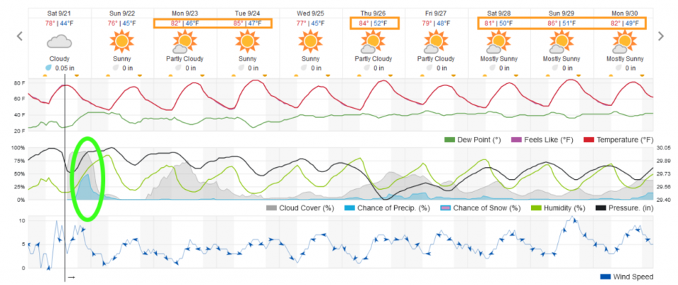
We dry out Sunday and stay just at normal temperatures for a day as the trough pulls by (Figure 4).

The Longer Range Forecast:

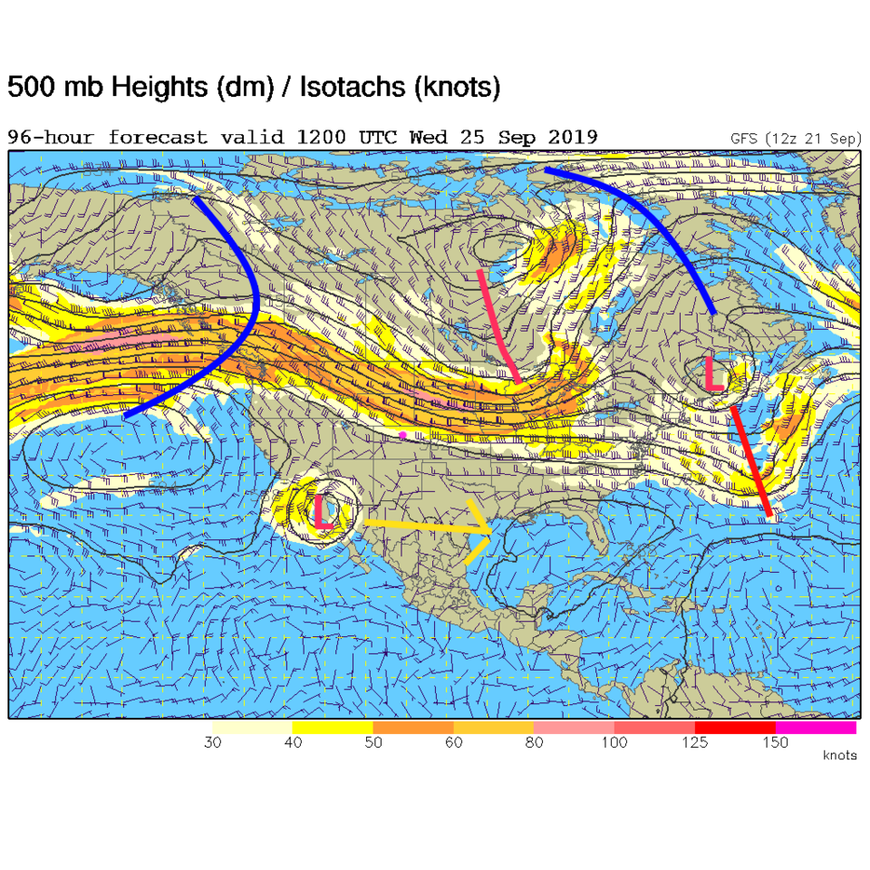
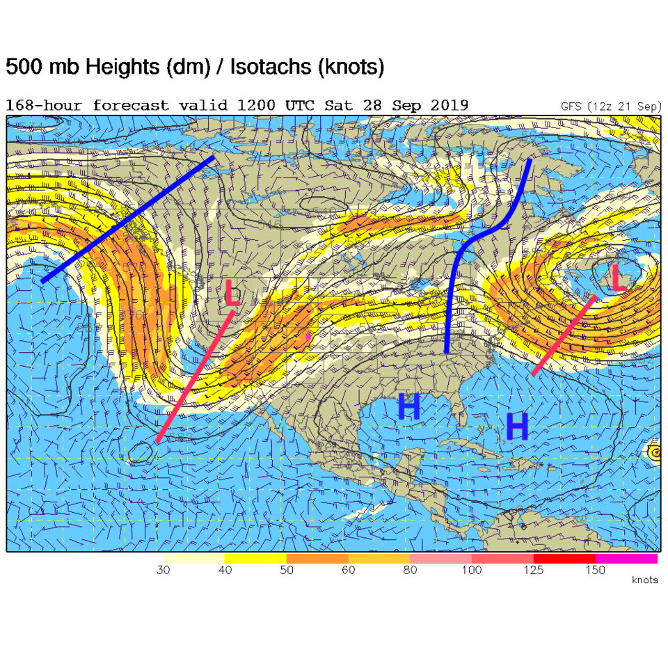
The cut-off low that was going to dump lots of water and snow on the state next week has a different plan. The GFS now shows it digging far south into northern Mexico (Figure 3). That feature won't matter much to our weather story now.

The week ahead will be about 5-10F above average as temperatures go with some better heat next weekend as another west coast trough pumps southwest winds across the state (Figure 5). I've highlighted days at or above 80F in Figure 4. There isn't much exciting going on. Sorry!

Happy First Day of Fall Monday! The Autumnal Equinox officially arrives at 1:50 p.m. MDT

Figure 1: The 500mb current upper air analysis for Saturday PM. Pink dot is Longmont. Red lines are troughs, blue lines are ridges.
Figure 2: the 12 hour precipitation total forecast from the HRRR and weather5280.com through 1am.
Figure 3: The 500mb forecast upper air analysis for Wednesday AM. Pink dot is Longmont. Red lines are troughs, blue lines are ridges.
Figure 4: the graphical forecast for the next 10 days for Longmont, CO from weatherunderground.com
Figure 5: The 500mb forecast upper air analysis for Saturday AM. Pink dot is Longmont. Red lines are troughs, blue lines are ridges.

Current Weather

Mostly cloudy

Mostly cloudy

38°F

UV Index
0 Low
Pressure
30.21 Rising
Visibility
8 miles
Dewpoint
31 °F
Humidity
74%
Wind
ESE 1.6 mph
Gust
3.8 mph
Wind Chill
38 °F

Hourly Forecast

Today
3 AM
39°F
Showers
Today
4 AM
38°F
Partly cloudy
Today
5 AM
38°F
Partly cloudy
Today
6 AM
37°F
Partly sunny
Today
7 AM
39°F
Partly sunny
Today
8 AM
42°F
Mostly sunny
Today
9 AM
45°F
Mostly sunny
Today
10 AM
49°F
Mostly sunny
Today
11 AM
53°F
Mostly sunny
Today
12 PM
55°F
Mostly sunny
Today
1 PM
59°F
Mostly sunny
Today
2 PM
61°F
Partly sunny

7 Day Forecast

Mostly cloudy w/ showers

Friday

76 °F

Some sun, then increasing clouds, becoming breezy in the afternoon with a shower in spots late


Partly cloudy w/ showers

Friday Night

37 °F

Partly cloudy with a couple of showers


Partly sunny

Saturday

66 °F

Partly sunny and not as warm


Mostly clear

Saturday Night

40 °F

Clear to partly cloudy


Mostly cloudy

Sunday

76 °F

Mostly cloudy and warmer; breezy in the afternoon


Mostly cloudy

Sunday Night

47 °F

Rather cloudy; breezy late


Windy

Monday

60 °F

Very windy; cloudy and cooler


Intermittent clouds

Monday Night

43 °F

Partly cloudy


Intermittent clouds

Tuesday

62 °F

Windy with times of clouds and sun


Partly cloudy

Tuesday Night

36 °F

Partly cloudy


Sunrise and Sunset

Sunrise
5:57 AM
Sunset
7:58 PM

Based on AccuWeather data