Skip to content

11am 9/6 Update: Next Storm/Next Snow Forecast Discussion from the Cherrywood Observatory – September 6-7, 2019

This content was originally published by the Longmont Observer and is licensed under a Creative Commons license.

In Brief:

Big fronts and little fronts are now going to flow across the state. Tropical moisture will feed into this more unstable environment (with short waves traveling by daily) and we should see rain now and then. We hang out with highs in the 80'sF for the next 8-10 days. Nice.

11am 9/6 Update:

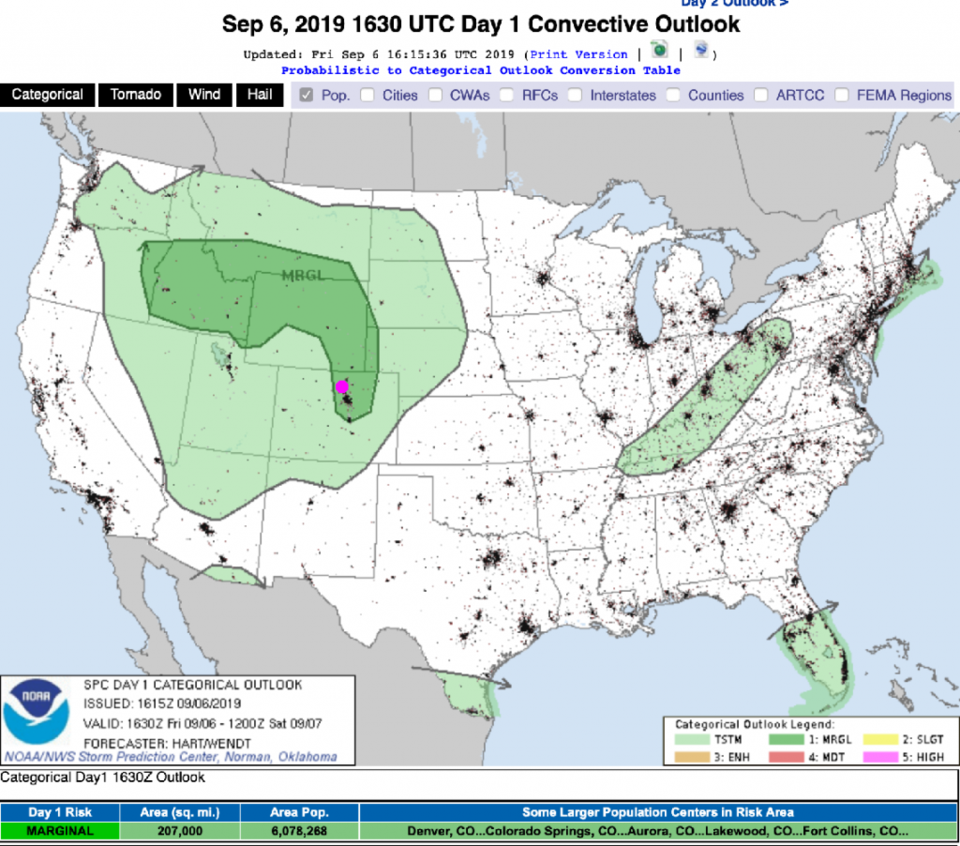
With a big ridge to our south and a somewhat healthy passing short wave trough, we have a Marginal Risk of severe weather (Figure 1 update) along the Front Range today. Storms should be wandering after 2pm and before 7pm - mainly. Winds and hail are the primary risk. Carry on with your weekend!

Figure 1 update: The severe storm weather forecast for the U.S. from the Storm Predication Center in Norman, OK. Made Friday for Fridaty.

End 11am 9/6 Update.

Forecast Discussion:

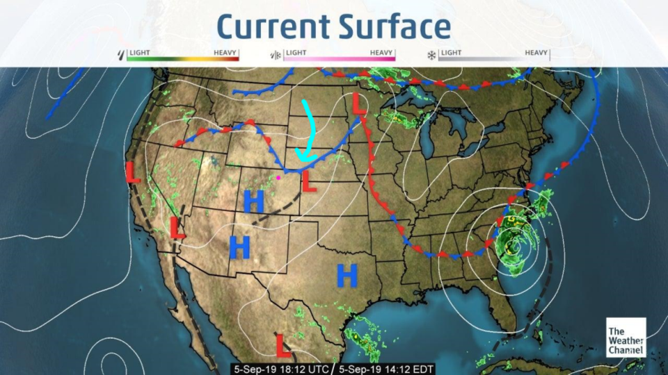
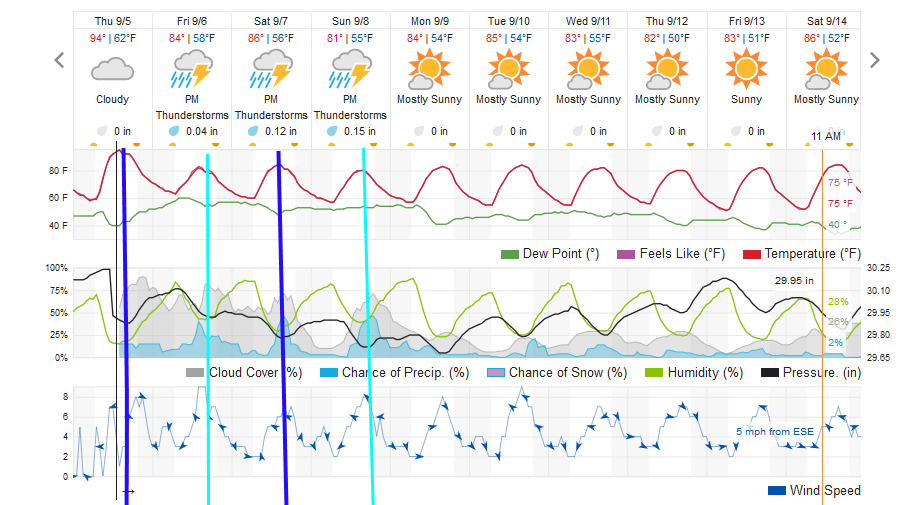
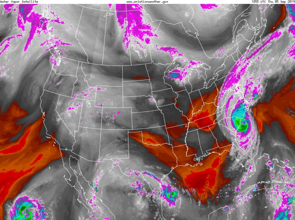
Our first cold front is sliding out of Wyoming and bringing in cooler air (Figure 1) today (Thursday). There is colder air aloft and moisture coming up into the West from the tropics (Figure 3). That means a better chance of afternoon storms everyday through Sunday (Figure 2). There might be a Marginal severe weather risk to the east of Denver Sunday, but nothing scary is expected around here.

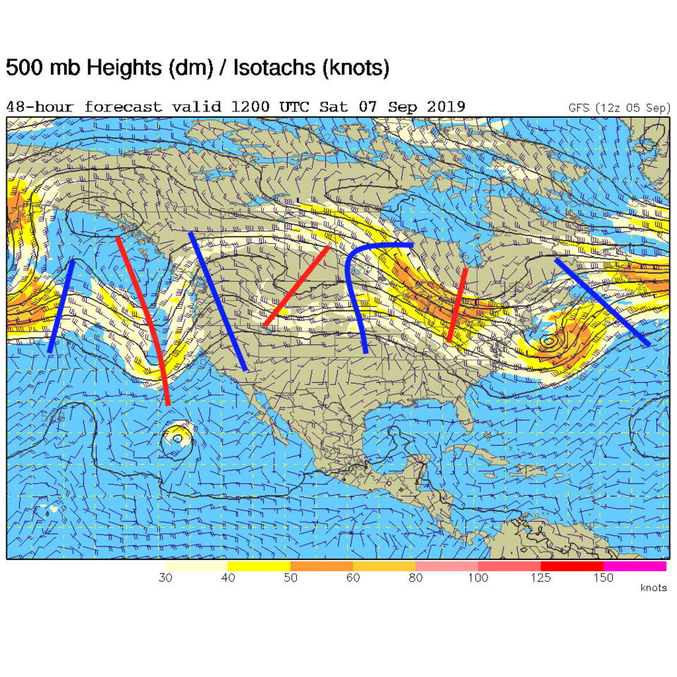
The driver for this is the natural progression of the jet stream southward as Fall comes on. There is a march of short wave troughs (red) and ridges (blue) - Figure 4. In this image, you can see the Saturday short wave bearing down on us. Note the stronger cold fronts in Figure 2 are dark blue lines, and weaker cool fronts are light blue in Figure 2.

The Longer Range Forecast:

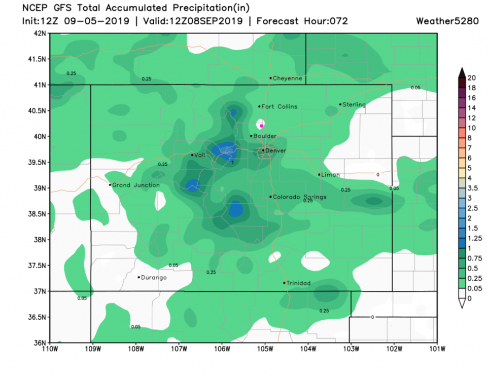
This cool, cloudy at times, and showery at times, weather continues through Sunday PM. We might see 1/4th to 1 inch of rain near Longmont (even if this model run puts a dry spot right on our head (Figure 5)). This will be a nice break from the heat. We dry out and stick with 80'sF for highs on through next weekend... and beyond?

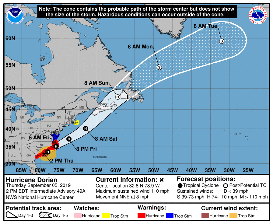
Hurricane Dorian is still making big news as it slides from the South Carolina coastline to the North Carolina (NC) coastline and may make a brief landfall in NC late Thursday PM or early Friday AM. By the time I make my next full post on Saturday, it should be out east of New England out at sea headed for a Canadian landfall.

Figure 1: The current surface analysis map from Thursday afternoon from the weatherchannel.com
Figure 2: the graphical forecast for the next 10 days for Longmont, CO from weatherunderground.com
Figure 3: the water vapor satellite image (browns/reds are dry air, whites and light grey is moist air, purple/blue is ice and high cloud tops). From the the NWS from Thursday PM.
Figure 4: The 500mb forecast upper air analysis for Saturday AM. Pink dot is Longmont. Red lines are troughs, blue lines are ridges.
Figure 5: the forecast accumulated precipitation map from the GFS and weather5280.com for Colorado, for the next 4 days.
Figure 6: The hurricane Dorian 5 day forecast map from the NHC and the NWS.

Current Weather

Mostly cloudy

Mostly cloudy

52°F

UV Index
3 Moderate
Pressure
29.82 Falling
Visibility
7 miles
Dewpoint
37 °F
Humidity
57%
Wind
NNE 1 mph
Gust
3.5 mph
Wind Chill
52 °F

Hourly Forecast

Today
11 AM
61°F
Mostly cloudy
Today
12 PM
65°F
Cloudy
Today
1 PM
69°F
Cloudy
Today
2 PM
72°F
Cloudy
Today
3 PM
75°F
Cloudy
Today
4 PM
78°F
Cloudy
Today
5 PM
77°F
Cloudy
Today
6 PM
75°F
Cloudy
Today
7 PM
73°F
Cloudy
Today
8 PM
69°F
Cloudy
Today
9 PM
66°F
Cloudy
Today
10 PM
63°F
Mostly cloudy

7 Day Forecast

Mostly cloudy

Sunday

78 °F

Rather cloudy and warmer; breezy this afternoon


Mostly cloudy

Sunday Night

47 °F

Mostly cloudy and windy


Windy

Monday

56 °F

Winds gusting past 40 mph; cloudy


Intermittent clouds

Monday Night

43 °F

Partly cloudy


Partly sunny w/ showers

Tuesday

59 °F

A couple of showers in the morning; otherwise, windy and cool with times of clouds and sun


Partly cloudy

Tuesday Night

32 °F

Partly cloudy


Intermittent clouds

Wednesday

58 °F

Times of clouds and sun


Intermittent clouds

Wednesday Night

38 °F

Partly cloudy


Intermittent clouds

Thursday

56 °F

Breezy and cool with sun and clouds


Intermittent clouds

Thursday Night

37 °F

Partly cloudy


Sunrise and Sunset

Sunrise
5:54 AM
Sunset
8:00 PM

Based on AccuWeather data