
This content was originally published by the Longmont Observer and is licensed under a Creative Commons license.
By John Ensworth
Discussion:
The moisture is still here (the Longmont dew point has dropped to 61F from 64F, still very moist), but the flow has pushed to our south again. First, the cooler air coming in yesterday stabilized the atmosphere in NE Colorado. Today, it is still some cooler air, and the moisture hanging off to the south, that limited rainfall. Some people (not Longmont, which only received about 10th of an inch of rain) got a lot of water from Denver south.
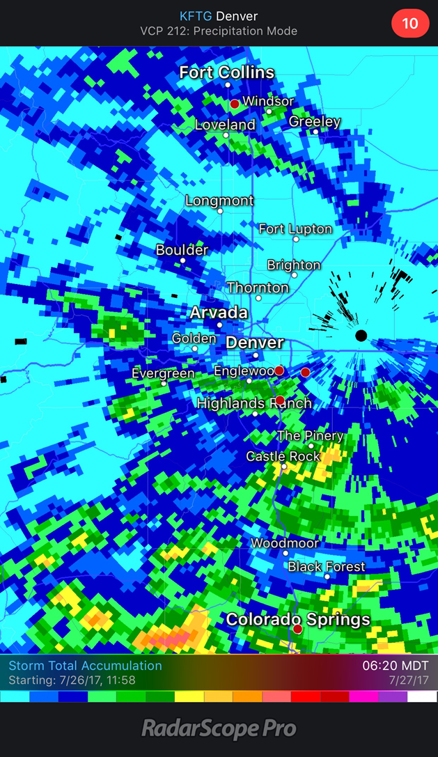
Figure 1: Radar estimated rainfall totals as of Thursday 6:30am. The dark blues are about 0.25”. The dark greens are 1.00” of rain. The dark oranges are 3.00” rain. Wow. Good for you people south of Denver.
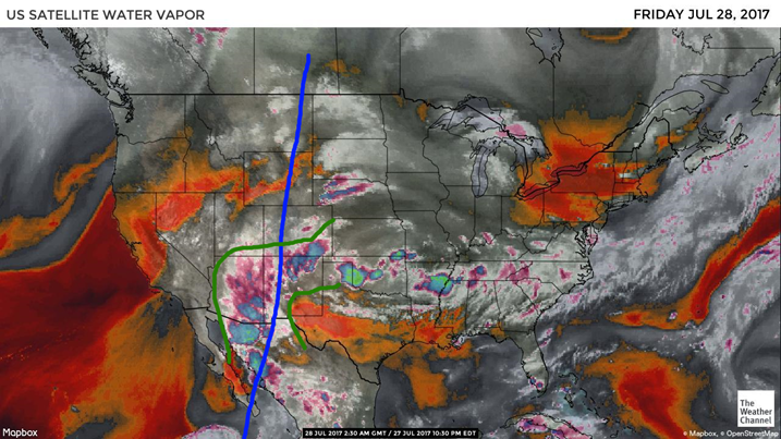
There is some moisture over all of Colorado (Figure 2) as seen in the medium grey hues, but the deeper moisture is down to the south of Longmont.
Figure 2: The water vapor satellite image with deeper moisture outlined in green. The upper level ridge axis is drawn in blue.
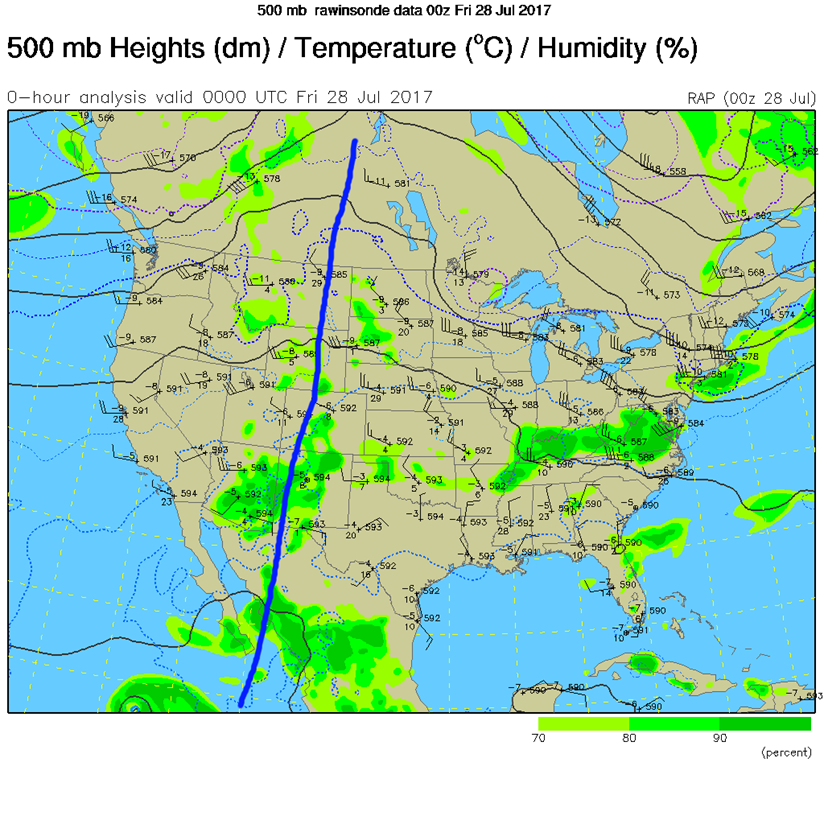
To see this ridge, drawn on Figure 2, we can look at the 500mb map as Figure 3.
Figure 3: The 500mb map – current conditions Thursday PM.
The current (Thursday PM) weather map shows the copious amount of moisture and resulting thunderstorm activity across Arizona and New Mexico. Things are already dying out in Colorado with the setting of the sun.
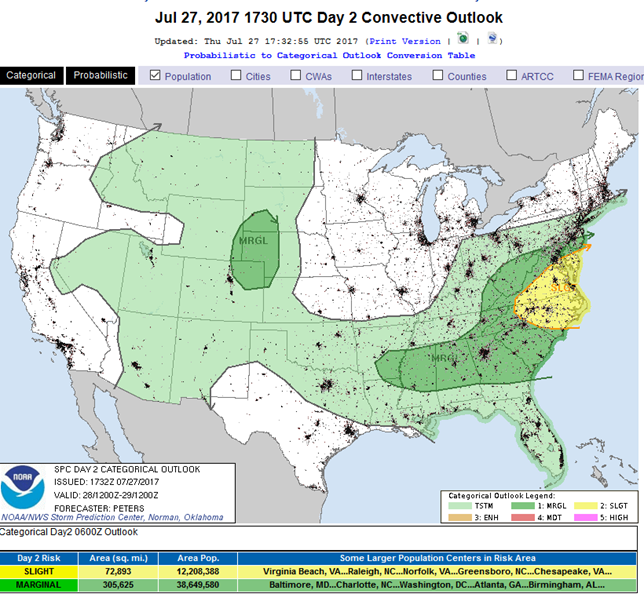
Figure 4: The day 3 (from Wednesday night) Friday severe weather outlook.
With some upper level waves, the possibility of easterly surface winds coming up the Plains, and low level moisture lingering, we might see what is called the Denver Cyclone (defined next) set up over the city. The Marginal Risk (1 on a scale of 1-5) previously forecasted for us is now expected to impact areas east of I-25 (unless this Denver Cyclone – a small scale low pressure circulation caused by the direction of incoming air to the shape of the mountain ranges around Denver – then large hail and strong winds might strike south of Longmont).
Figure 5: The Storm Prediction Center severe weather risk forecast from Thursday PM for Friday.
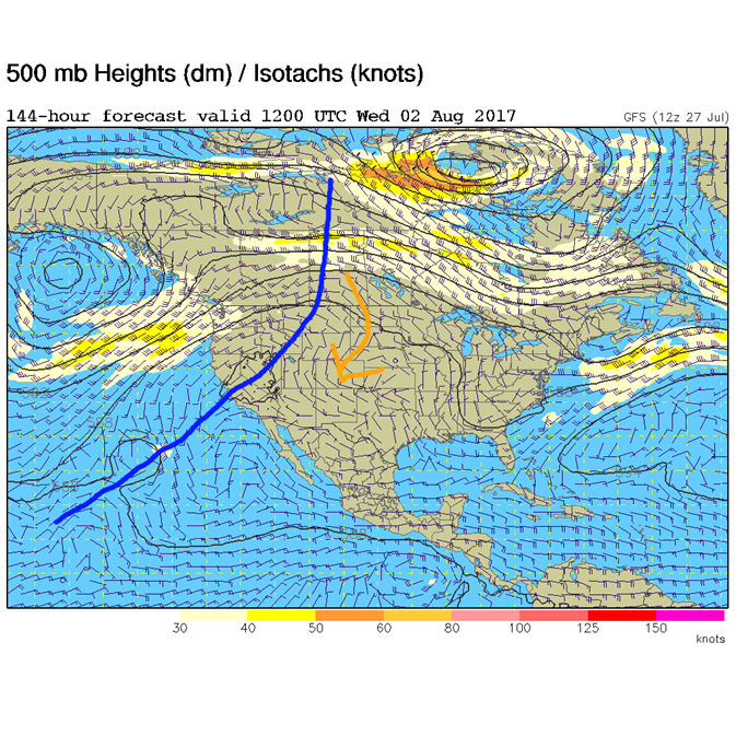
In a look at the longer range: The low level moisture sticks around into early next week, but the ridge heads back west making the atmosphere sink (less stormy) more than it has been. That will suppress widespread rain. Temperatures will also inch back to the low 90’s. The ridge hangs out to our west on into next week. The ridge position Monday morning and Wednesday morning is marked in Figure 6 and 7. The orange arrows show drier upper level air coming in. Darn.
Figure 6: The forecast 500mb map for Monday morning.
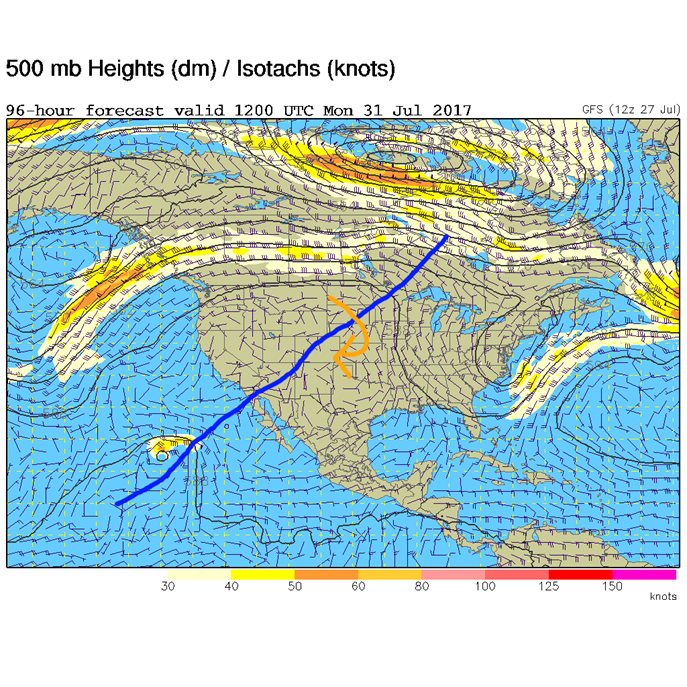
Figure 7: The forecast 500mb map for Monday morning.
*** This feature will run as close to daily as possible in this location on the Longmont Observer. This article will provide a brief discussion concerning the ‘why’ behind the weather with a focus on severe weather, unusual weather, and snow (especially trying to predict snow depth and its human impact in Longmont).***
Bio:
John Ensworth works from Longmont as the Principle Investigator for the NASA Science Mission Directorate Earth and space science education product review through the IGES (The Institute for Global Environmental Strategies – www.strategies.org) . He is in his 14thyear running this review. He is an astronomer (from the 2nd grade onward) and became a meteorologist (in the 5th grade) when a thunderstorm in Arizona rained on his telescope when the weather service had only forecasted a 10% chance of rain. He has college degrees in physics and astronomy and climatology and a graduate degree in meteorology and earth science. He lectures at the Little Thompson Observatory in Berthoud, the Estes Park Memorial Observatory in Estes Park, and for a number of online universities. He built and runs a backyard observatory near Pace and 17th in northeast Longmont where he has lived for 8 years with his wife, daughter, son, and two cats. Invitations to open house nights at this observatory, LTO, and EPMO will be posted with future discussions when they are scheduled.
Forecasting severe weather and snow amounts via text lead to this column. He began texting friends about the weather right after the September 2013 flood. The readers of this column will, hopefully, keep him honest in what he ‘thought’ he had forecasted for ‘the most recent’ storm.


