Skip to content

The Next Storm/Next Snow Forecast Discussion from the Cherrywood Observatory – November 4, 2017

This content was originally published by the Longmont Observer and is licensed under a Creative Commons license.

Forecast Discussion:

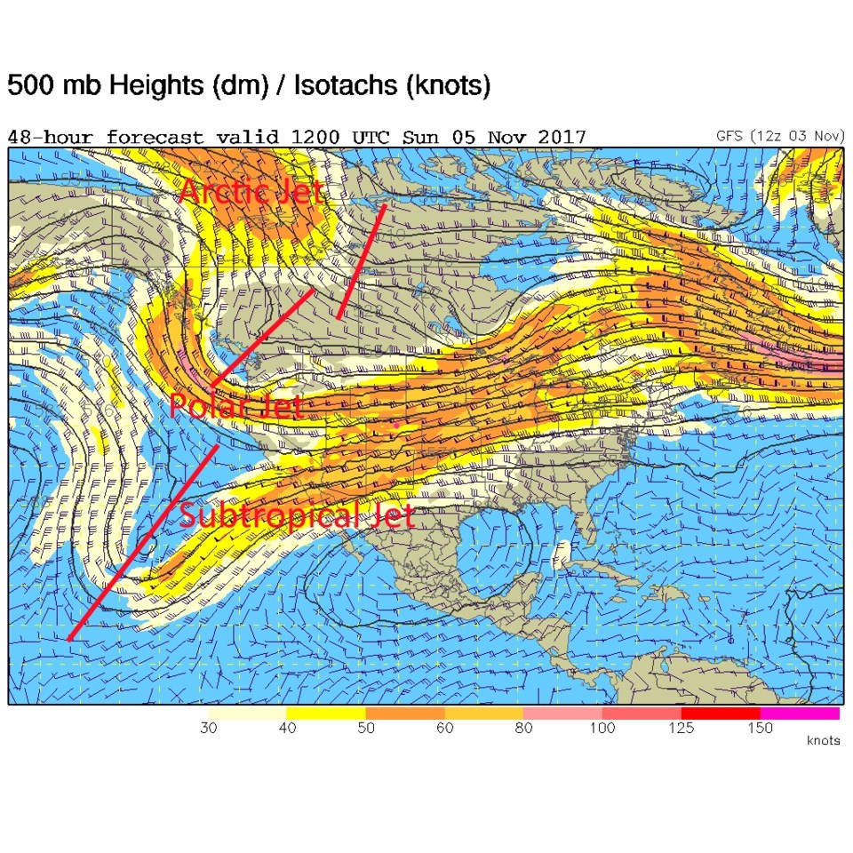
The westerlies made progress pushing the frontal air off to the east on Friday. Figure 1 shows the green and light blue (cooler air) now sitting over eastern Colorado and Kansas.  A darker blue tongue of warmer air has formed up the I-25 corridor on the right side of the stationary front drawn in.  We have two jet stream flows combining overhead bringing in a steady source of (limited at first) moisture and wind energy to the western side of the Rockies (Figure 2).  Down slope winds will pick up on Saturday to warm us up and blow things around.

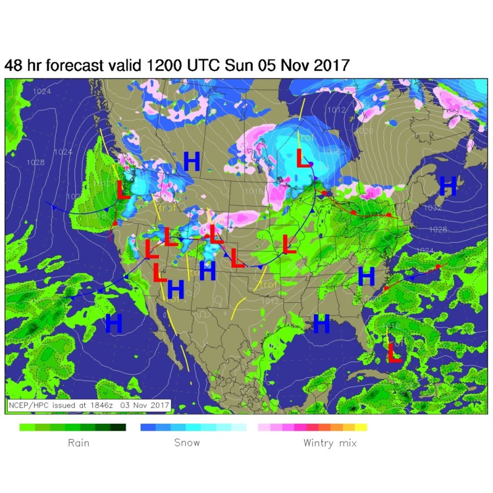
That westerly flow will mean snow for the western slopes and higher elevations.  Figure 3 for Sunday morning shows a good amount of mountain snow west of us and a front that has pushed down into NE Colorado Saturday night.  Winds will die down again tonight and low clouds and drizzle will return again.

Figure 1: Infrared satellite image and surface analysis from NOAA Friday PM.

Figure 2: The 500mb upper air forecast map for Sunday morning.

Figure 3: The surface forecast map for Sunday morning.

In the longer range forecast:

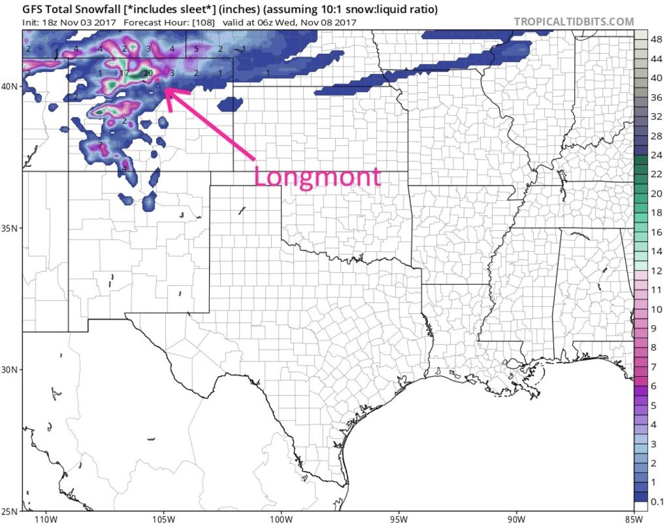
The Saturday PM and Sunday front won't mean much rain for us, but another system coming in Tuesday may still give Longmont some snow. Figure 4 shows the total accumulation of snow up through Monday night.  There are 13 and 15 inch snow amounts in the higher mountains, but nothing here in town.  In Figure 5 we add on the time periods through Wednesday morning. It looks like we might see 2-3 inches by this model run.  More later!

Figure 4: Total snow accumulation according to the GPS from Friday PM to Monday PM.

Figure 5: Total snow accumulation according to the GPS from Friday PM to Wednesday AM.

Current Weather

Mostly sunny

Mostly sunny

71°F

UV Index
3 Moderate
Pressure
29.59 Falling
Visibility
8 miles
Dewpoint
44 °F
Humidity
38%
Wind
NE 3.9 mph
Gust
10 mph
Wind Chill
71 °F

Hourly Forecast

Today
5 PM
75°F
Cloudy
Today
6 PM
73°F
Cloudy
Today
7 PM
72°F
Cloudy
Today
8 PM
68°F
Cloudy
Today
9 PM
66°F
Cloudy
Today
10 PM
62°F
Mostly cloudy
Today
11 PM
60°F
Intermittent clouds
Tomorrow
12 AM
58°F
Intermittent clouds
Tomorrow
1 AM
56°F
Intermittent clouds
Tomorrow
2 AM
55°F
Mostly cloudy
Tomorrow
3 AM
54°F
Cloudy
Tomorrow
4 AM
52°F
Cloudy

7 Day Forecast

Mostly cloudy

Sunday

75 °F

Rather cloudy and warmer


Windy

Sunday Night

47 °F

Winds becoming strong; cloudy most of the time


Windy

Monday

56 °F

Winds gusting past 40 mph; cloudy and cooler


Intermittent clouds

Monday Night

42 °F

Partly cloudy


Partly sunny w/ showers

Tuesday

59 °F

A couple of showers in the morning; otherwise, windy and cool with times of clouds and sun


Partly cloudy

Tuesday Night

32 °F

Partly cloudy


Intermittent clouds

Wednesday

58 °F

Cool with times of clouds and sun


Intermittent clouds

Wednesday Night

38 °F

Partly cloudy


Intermittent clouds

Thursday

56 °F

Breezy and cool with sun and clouds


Intermittent clouds

Thursday Night

39 °F

Partly cloudy


Sunrise and Sunset

Sunrise
5:54 AM
Sunset
8:00 PM

Based on AccuWeather data