Skip to content

The Next Storm/Next Snow Forecast Discussion from the Cherrywood Observatory – November 6, 2017

This content was originally published by the Longmont Observer and is licensed under a Creative Commons license.

Forecast Discussion:

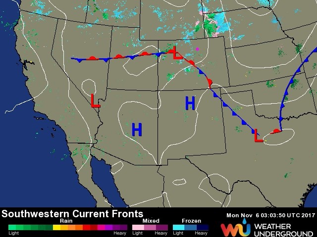
The first frontal system is stalled down the mountains and into southeastern parts of the state (Figure 1).  Light showers behind the front and mountain snows were the story Sunday with cooler weather than Saturday. Another front is on its way for Monday afternoon to really kick up winter weather... but, before that, we should see a good amount of fog behind the front Monday morning with some clearing skies overnight.  There may be a dense fog advisory issued for regions along I-25 by Monday morning.

The next front will enter the state early afternoon and pass through Longmont around 3-4pm.  Snow will begin falling behind the front around sunset (which now happens just before 5pm). And the temperatures will drop to hover around and below freezing through Tuesday.

Figure 1: Surface analysis from Sunday night. Longmont is the pink dot, as always (and in the rest of the images).

In the longer range:

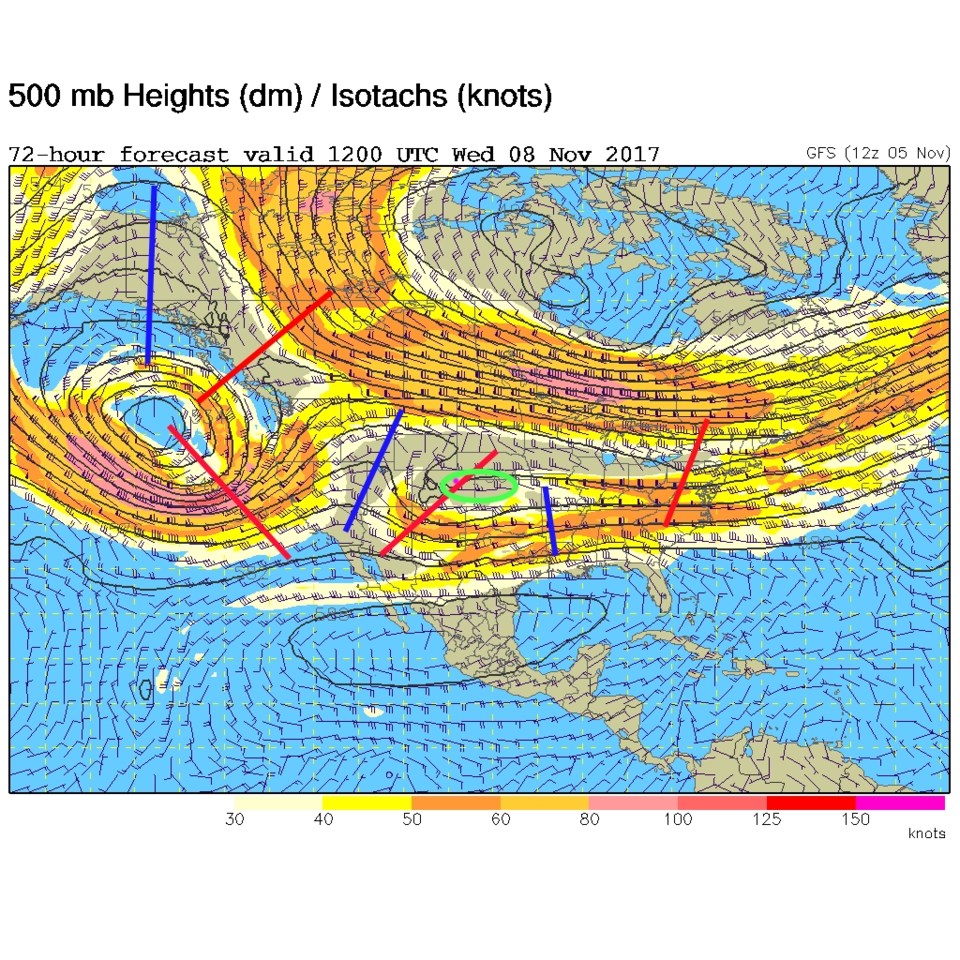
Figure 2 shows the complex upper air pattern with a trough passing over the state late Tuesday night. The area of lift will be pushing east of us by then ending the snow.

Amounts: According to weather5280.com, the forecasters there are calling for:

Fort Collins: 2 - 5"

Boulder: 1 - 4"

Denver: 0 - 3"

Castle Rock: 0 - 3" / Some icing potential

Colorado Springs: 0 - 2" / Some icing potential

I'll add that Longmont will be in the 1/2 - 3" area for snowfall. Estes park is in the 3-6" area.

We can also take a quick look at a number of models for Longmont.

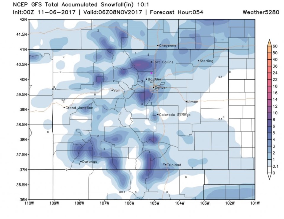
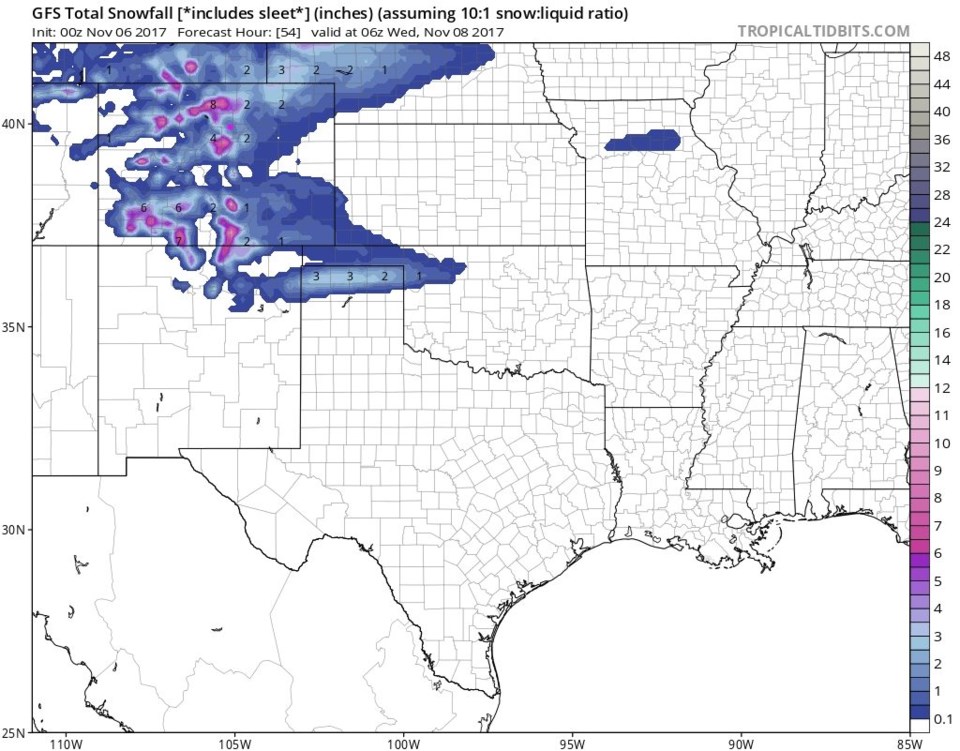
Figure 3 and 4 are the GFS (the first is the zoomed in version). It has Longmont at about 2-3"

Figure 5 is the NMM that puts us in the 1-2" area.

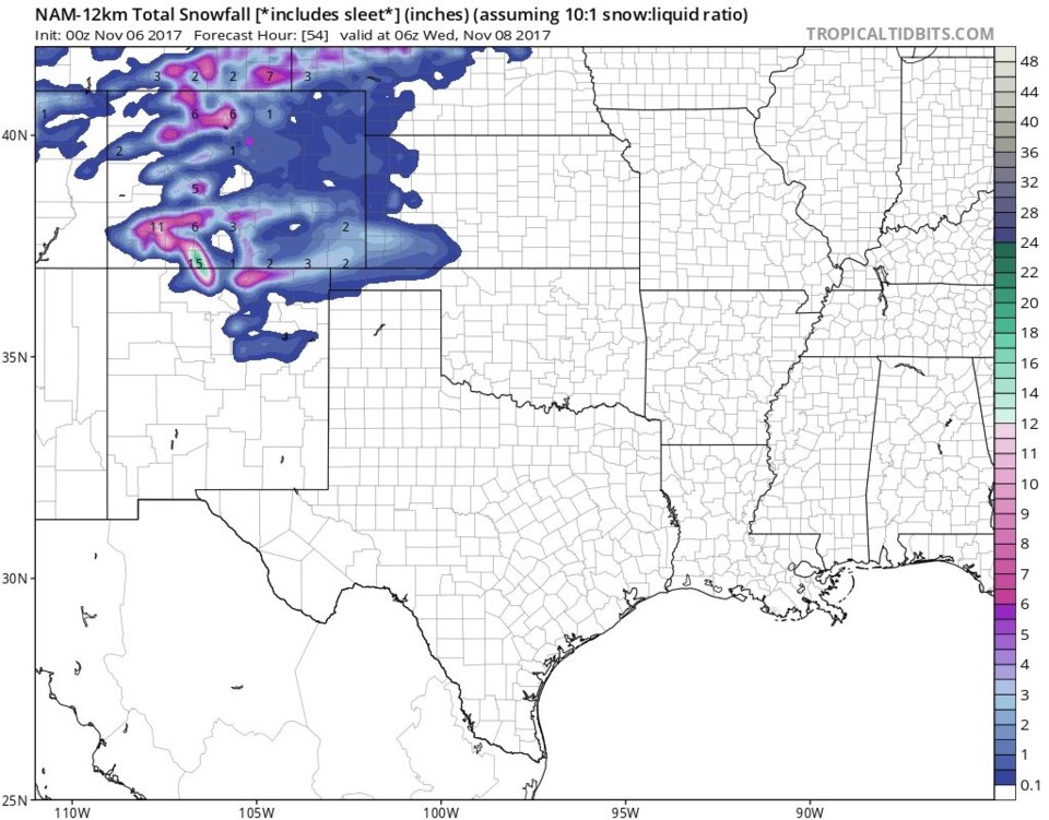
Figure 6 is the NAM that puts us in the 1 to 1 1/2" area.

It just isn't a big storm. We have yet to really get hit yet this season.

Timing: The snow will fall primarily between 8pm Monday and 12pm Tuesday with lingering snow flurries possible into Tuesday night. A light dusting now and then might still occur through early Wednesday AM.

Figure 2: 500mb upper air forecast map for late Tuesday PM.

Figure 3: Total snow forecast (close up) Sunday PM to Tuesday PM from the GSF.

Figure 4: Total snow forecast (wide view) Sunday PM to Tuesday PM from the GSF.

Figure 5: Total snow forecast (wide view) Sunday PM to Tuesday PM from the NMM.

Figure 6: Total snow forecast (wide view) Sunday PM to Tuesday PM from the NAM.

Current Weather

Mostly cloudy

Mostly cloudy

51°F

UV Index
0 Low
Pressure
30.02 Rising
Visibility
7 miles
Dewpoint
32 °F
Humidity
48%
Wind
ESE 4.9 mph
Gust
10.2 mph
Wind Chill
51 °F

Hourly Forecast

Today
9 PM
50°F
Showers
Today
10 PM
47°F
Partly cloudy
Today
11 PM
45°F
Partly cloudy
Tomorrow
12 AM
43°F
Partly cloudy
Tomorrow
1 AM
41°F
Partly cloudy
Tomorrow
2 AM
41°F
Partly cloudy w/ showers
Tomorrow
3 AM
40°F
Partly cloudy w/ showers
Tomorrow
4 AM
39°F
Partly cloudy
Tomorrow
5 AM
39°F
Partly cloudy
Tomorrow
6 AM
37°F
Partly sunny
Tomorrow
7 AM
39°F
Partly sunny
Tomorrow
8 AM
42°F
Partly sunny

7 Day Forecast

Mostly cloudy w/ showers

Friday

76 °F

Some sun, then increasing clouds, becoming breezy this afternoon with a shower in spots late in the afternoon


Partly cloudy w/ showers

Friday Night

37 °F

Partly cloudy with a couple of showers


Partly sunny

Saturday

66 °F

Not as warm with sun and some clouds


Mostly clear

Saturday Night

39 °F

Clear to partly cloudy


Mostly cloudy

Sunday

76 °F

Mostly cloudy and warmer; breezy in the afternoon


Mostly cloudy

Sunday Night

51 °F

Rather cloudy; windy late


Windy

Monday

60 °F

Winds gusting past 40 mph; cloudy and cooler


Intermittent clouds

Monday Night

43 °F

Breezy in the evening; otherwise, partly cloudy


Intermittent clouds

Tuesday

62 °F

Times of clouds and sun; windy in the afternoon


Intermittent clouds

Tuesday Night

36 °F

Clearing


Sunrise and Sunset

Sunrise
5:57 AM
Sunset
7:58 PM

Based on AccuWeather data