Skip to content

Next Storm/Next Snow Forecast Discussion from the Cherrywood Observatory – January 9, 2019

This content was originally published by the Longmont Observer and is licensed under a Creative Commons license.

Forecast Discussion:

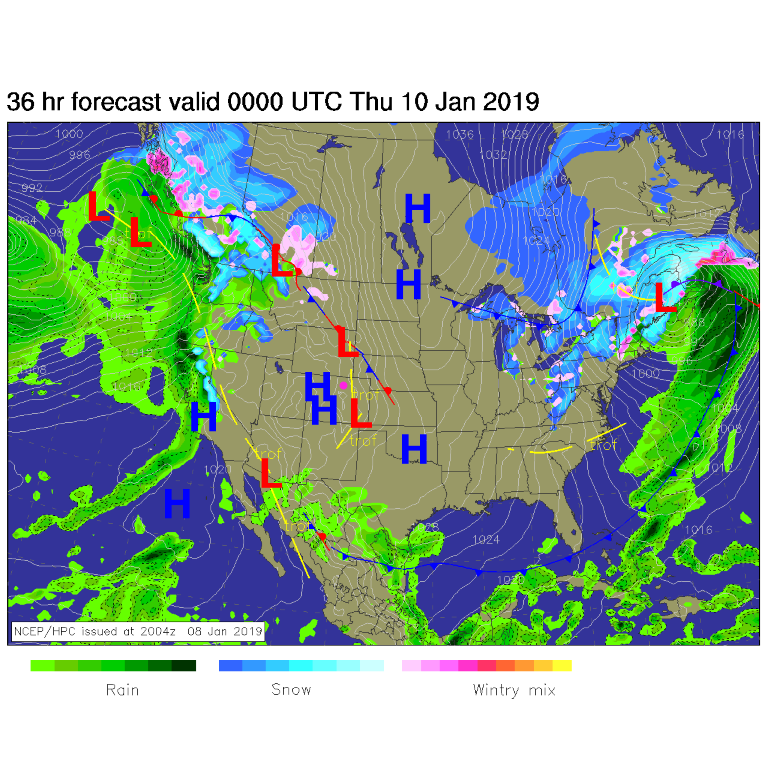
High pressure and beautiful (if not unusually warm and dry) skies keep on happening (Figure 1). Our next storm is bashing itself apart against the west coast of North America.

Figure 1: The forecast surface map for Wednesday PM. From NCEP.

The longer range forecast:

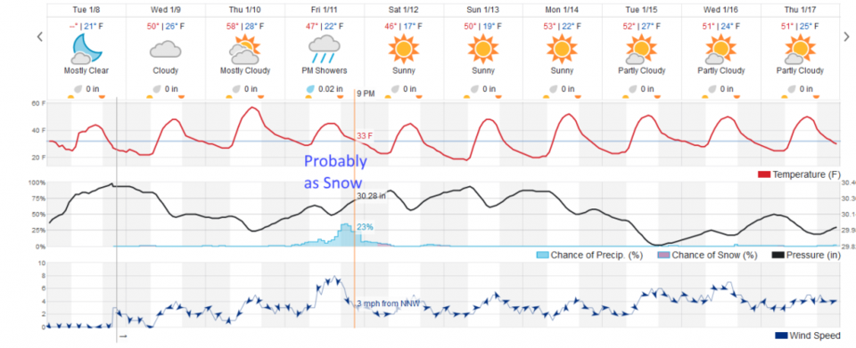
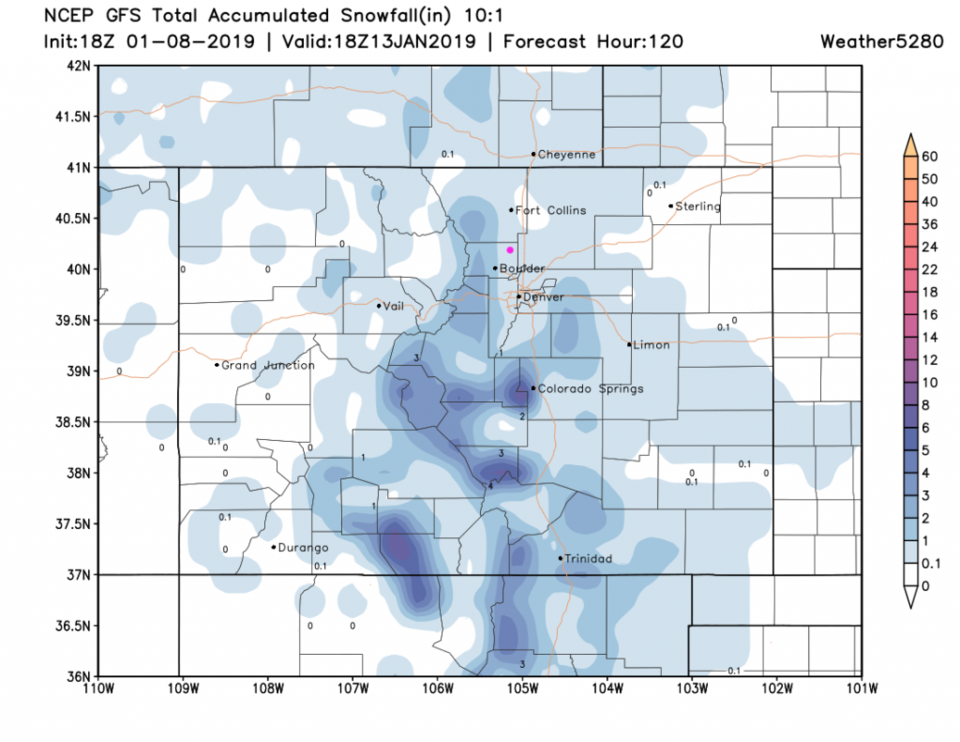
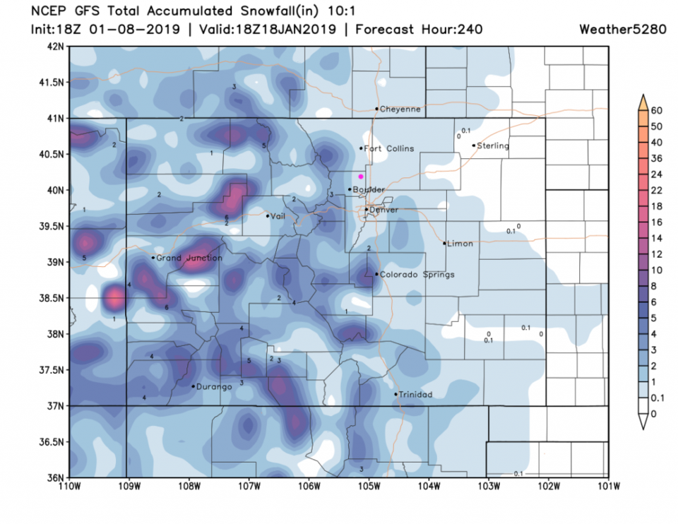
When that storm arrives, a weak front will interact with some moisture and give the plains a bit more of a precipitation chance than we've had since just after Christmas. Friday, we might get some measurable precipitation. Weatherunderground's model (Figure 2) labels it as rain, but temperatures will be near the 30's F and will lower once precipitation starts to fall, so it will probably fall as snow. Not much snow though... Figure 3, the GFS suggests a coating to 1 inch around Longmont. Looking out 10 days, that is our only chance here. Figure 4 has the same snow amount for us, but more snow on the western slopes and high mountains (great for them!).

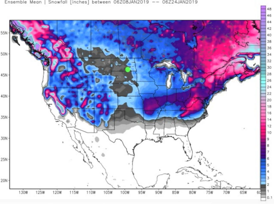
A bonus: an ensemble run from weatherbell looking out 16 days gives us 2-3 inches of snow over the next two weeks. I'm still waiting for that big winter to start! (Figure 5)

Figure 2: the graphical forecast for the next 10 days forecast for Longmont, CO from weatherunderground.com

Figure 3: The forecast accumulated snow map from the GFS and weather5280.com for Colorado, for the next 5 days (through end of weekend).

Figure 4: The forecast accumulated snow map from the GFS and weather5280.com for Colorado, for the next 10 days.

Figure 5: The forecast accumulated snow map from weatherbell.com for the U.S., for the next 16 days.

Current Weather

Cloudy

Cloudy

54°F

UV Index
3 Moderate
Pressure
30.15 Falling
Visibility
7 miles
Dewpoint
31 °F
Humidity
41%
Wind
SE 3.3 mph
Gust
8 mph
Wind Chill
54 °F

Hourly Forecast

Today
12 PM
53°F
Partly sunny
Today
1 PM
58°F
Mostly sunny
Today
2 PM
61°F
Partly sunny
Today
3 PM
63°F
Partly sunny
Today
4 PM
65°F
Intermittent clouds
Today
5 PM
66°F
Intermittent clouds
Today
6 PM
65°F
Intermittent clouds
Today
7 PM
63°F
Intermittent clouds
Today
8 PM
60°F
Mostly clear
Today
9 PM
57°F
Mostly clear
Today
10 PM
55°F
Mostly clear
Today
11 PM
52°F
Mostly clear

7 Day Forecast

Intermittent clouds

Saturday

66 °F

Not as warm with intervals of clouds and sunshine


Mostly clear

Saturday Night

39 °F

Clear to partly cloudy


Mostly cloudy

Sunday

77 °F

Mostly cloudy and warmer; breezy in the afternoon


Mostly cloudy

Sunday Night

45 °F

Rather cloudy; breezy late


Windy

Monday

60 °F

Very windy; cloudy and cooler


Intermittent clouds

Monday Night

43 °F

Partly cloudy


Intermittent clouds

Tuesday

62 °F

Times of clouds and sun; windy in the afternoon


Partly cloudy

Tuesday Night

36 °F

Partly cloudy


Intermittent clouds

Wednesday

60 °F

Times of clouds and sun


Intermittent clouds

Wednesday Night

35 °F

Partly cloudy


Sunrise and Sunset

Sunrise
5:55 AM
Sunset
7:59 PM

Based on AccuWeather data