Skip to content

Next Storm/Next Snow Forecast Discussion from the Cherrywood Observatory – November 9th, 2018

This content was originally published by the Longmont Observer and is licensed under a Creative Commons license.

Forecast Discussion:

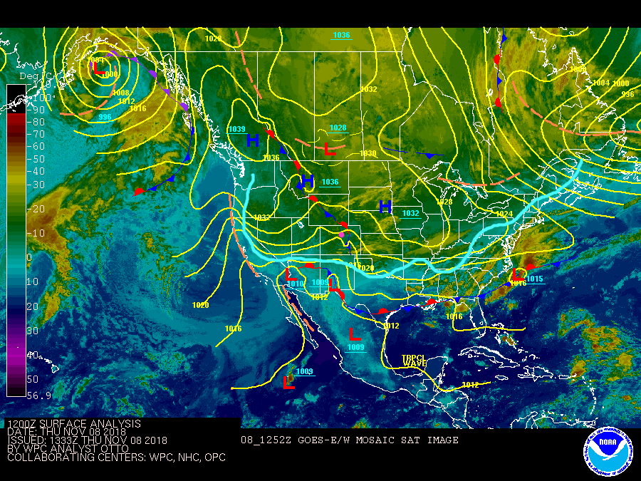
The Wednesday p.m./Thursday a.m. storm didn't do much around the Front Range but it did kick up chilly, breezy conditions. Thursday midday (Figure 1) I've outlined the invasion of cold air down into the U.S. We are sitting firmly north of this boundary with temperatures in the next few afternoons only climbing into the 40's F. Brrr.

The next storm is in the longer range forecast below...

Figure 1: The Infrared Satellite Image (cold temperatures are yellow/green, warm are dark blue) and the surface frontal analysis and pressure from Thursday midday from NOAA.

The longer range forecast:

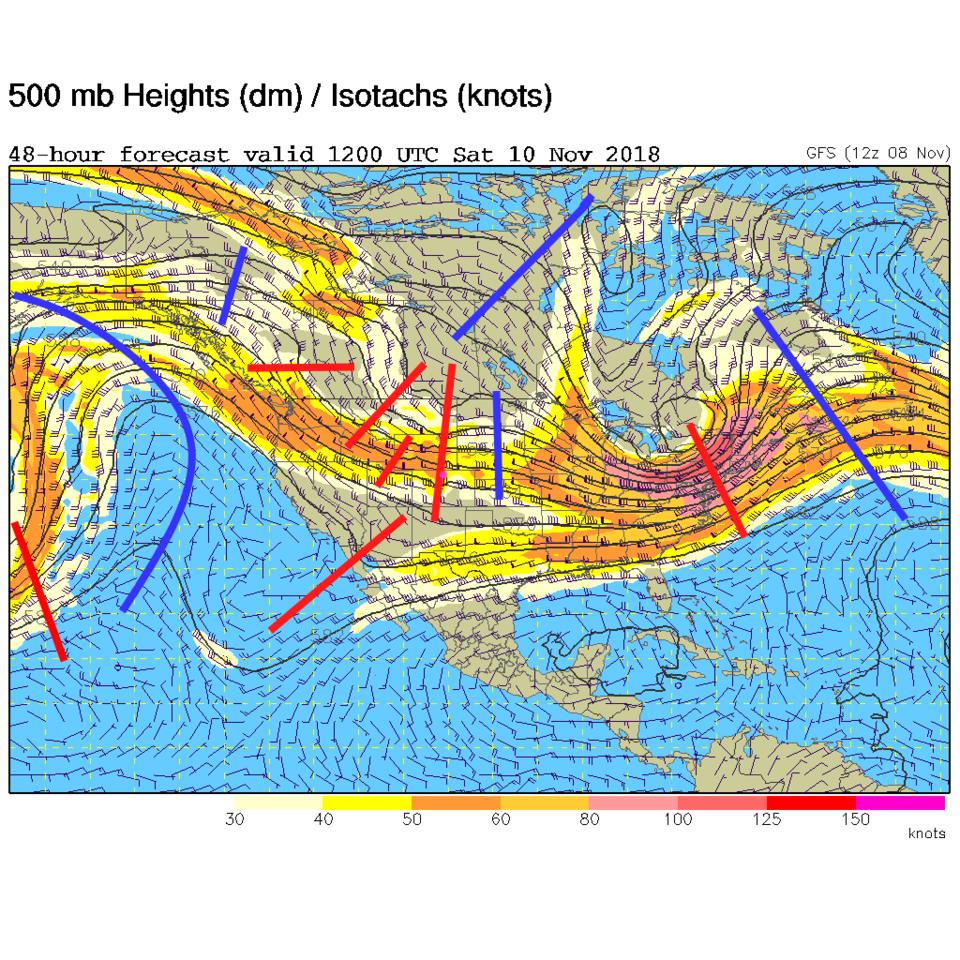
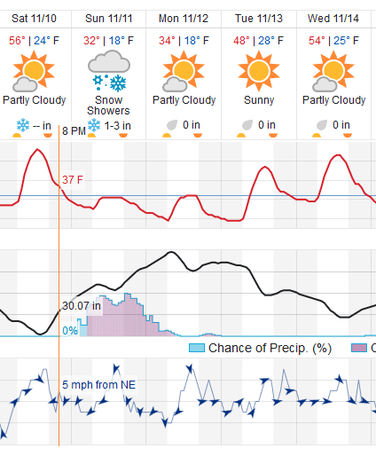
We'll have southwest flow in the lower atmosphere on Saturday that will push us up to the 50's F before a cold front slides south over the region hitting Longmont around 5 p.m. (See Figure 3). The stronger up-slope flow won't start until later in the evening with the bulk of the lift and snow occurring Sunday morning, day, and on into the evening. This is related to the complexity of short wave troughs in the upper atmosphere invading the state on Saturday into Sunday (Figure 2).

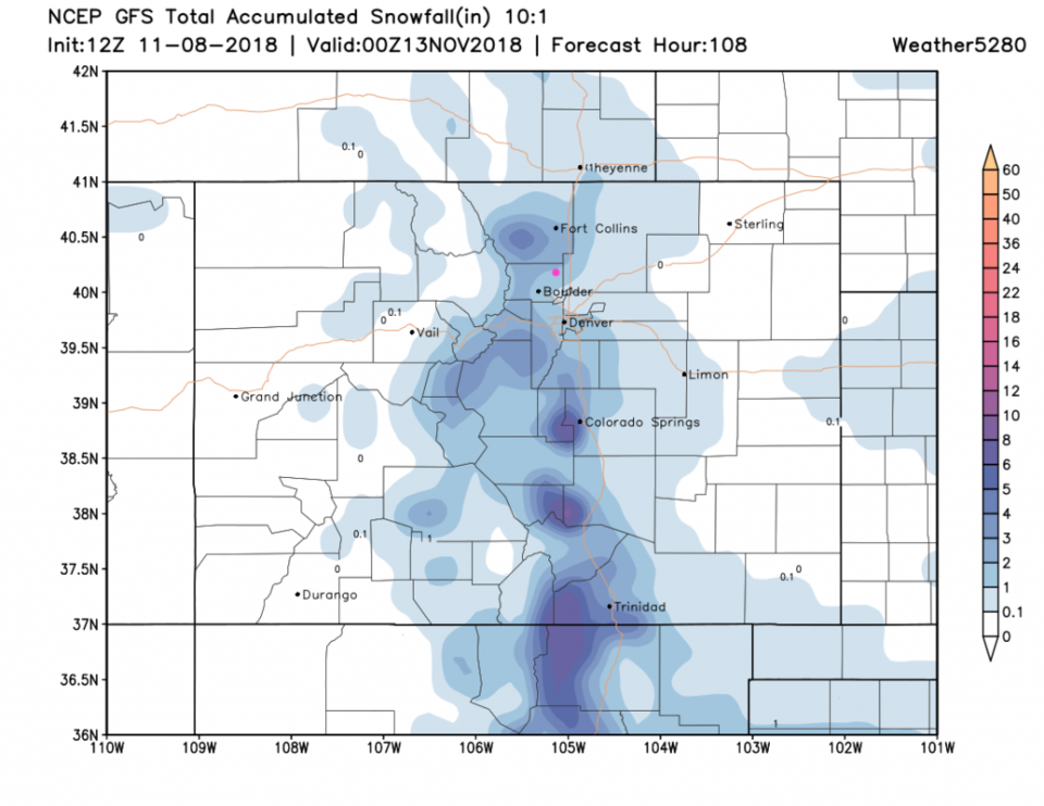
The weatherunderground.com model (Figure 3 again) gives us 1-3 inches of snow between 1 a.m. Sunday and 5 a.m. Monday. Not a gigantic storm, but a nice coating. The GFS, Figure 4, has us right around 2 inches of snow through Monday p.m. (the window I chose). They are agreement at this point, so be prepared for a cloudy, snowy, cold, raw Sunday and a cold Monday. (We'll see a low of about 18°F Monday morning followed by a high barely above freezing). Get that coat ready!

Figure 2: The 500mb forecast upper air analysis for Saturday AM. Pink dot is Longmont. Red lines are troughs, blue lines are ridges.

Figure 3: the piece of the next 10 days of the graphical forecast for Longmont, CO from weatherunderground.com

Figure 5: The forecast accumulated snow map from the GFS and weather5280.com for Colorado for the next 4 days, through Monday PM. Longmont is the pink dot, as always.

Current Weather

Sunny

Sunny

41°F

UV Index
1 Low
Pressure
30 Rising
Visibility
9 miles
Dewpoint
22 °F
Humidity
47%
Wind
E 3.1 mph
Gust
6.4 mph
Wind Chill
39 °F

Hourly Forecast

Today
7 AM
38°F
Mostly cloudy
Today
8 AM
43°F
Mostly sunny
Today
9 AM
47°F
Mostly sunny
Today
10 AM
51°F
Mostly sunny
Today
11 AM
55°F
Mostly sunny
Today
12 PM
58°F
Mostly sunny
Today
1 PM
60°F
Partly sunny
Today
2 PM
62°F
Intermittent clouds
Today
3 PM
63°F
Mostly cloudy
Today
4 PM
64°F
Mostly cloudy
Today
5 PM
63°F
Cloudy
Today
6 PM
61°F
Cloudy

7 Day Forecast

Intermittent clouds

Thursday

64 °F

A blend of sun and clouds; breezy this afternoon


Mostly cloudy

Thursday Night

35 °F

Mostly cloudy


Partly sunny

Friday

68 °F

Increasingly windy with partial sunshine


Partly cloudy

Friday Night

38 °F

Partly cloudy


Partly sunny

Saturday

66 °F

Partial sunshine


Mostly clear

Saturday Night

41 °F

Clear to partly cloudy


Mostly cloudy

Sunday

78 °F

Rather cloudy and warmer; windy in the afternoon


Intermittent clouds

Sunday Night

43 °F

Partly cloudy; windy late


Mostly cloudy

Monday

60 °F

Mostly cloudy, breezy and cooler


Mostly cloudy

Monday Night

43 °F

Mostly cloudy


Sunrise and Sunset

Sunrise
5:58 AM
Sunset
7:57 PM

Based on AccuWeather data