Skip to content
Join our Newsletter

Monday Update The Front Range Forecast: Low impact storm again

In Brief:

Warm through Tuesday morning, a brief small snow storm for Wednesday, then another rapid warmup.

Monday Update:

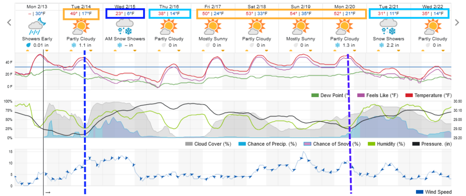
As has happened a few times now, a big storm has decided to track further to the south by the time it approaches Colorado. The front arrives about 2pm Tuesday with snow showers through the night into Wednesday afternoon (Figure 1 update).  It gets briefly cold again (48 hours) then 50's return.

Around Longmont and Broomfield, it looks like a coating to locally 3 inches are possible (Figure 2 update). Fort Collins may receive only a trace to a coating. Denver may see 3-4 inches while areas in southern Colorado get 1 to 2 feet.  Sorry this isn't one to create many snow-day closings in northern Colorado.

figure1u_02132023
Figure1 update: the 10 day graphical forecast for Denver from weatherunderground.com
figure2u_02132023
Figure 2 update: the 4 day 10:1 snowfall total from the GFS and weather5280.com

End Monday Update.

The Forecast Discussion:

A strong ridge overhead and westerly flow has resulted in very warm temperatures.  Some healthy ice removal should happen through Tuesday. Enjoy! Figure 1. (I have a few Christmas decorations buried out there I hope to recover!)

figure1_02112023
Figure 1: the 10 day graphical forecast for Denver from weatherunderground.com

The Longer Range Forecast:

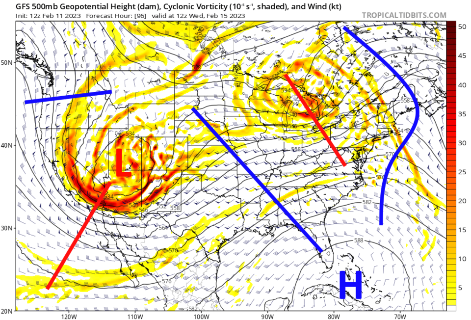
Our next cold front arrives from the Pacific around sunset Tuesday. Temperatures will not be arctic cold, but cold enough for some healthy snow. This is driven by a deep trough with embedded short waves (smaller, quicker moving troughs - red lines in Figure 2).

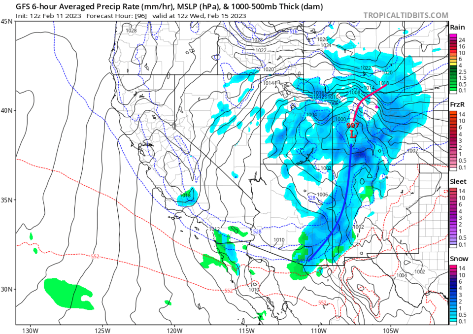
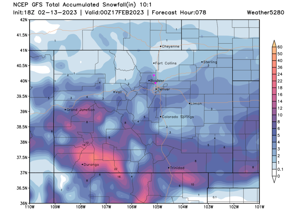
This is a bigger storm, in area compared to recent upslope storms, that will be dropping snow from northern Mexico up into Wyoming (Figure 3). It won't miss us, but how much snow it drops in any one place is still quite variable from model run to model run.

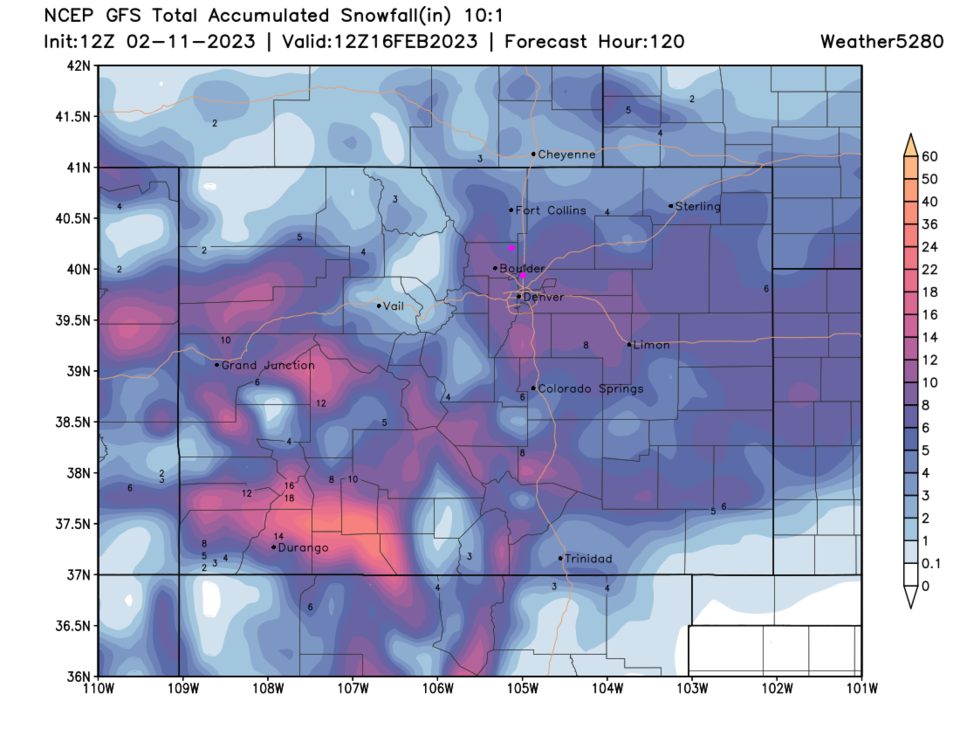
Currently, the GFS has widespread 8 inch totals from Limon to Denver and Boulder including Broomfield (Figure 4). We shave a few inches off the forecast snow amounts from Meade to Fort Collins.

We warm up quickly again after this storm. We shouldn't see the long-term ice problems we had with the last series of systems.

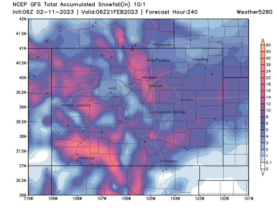
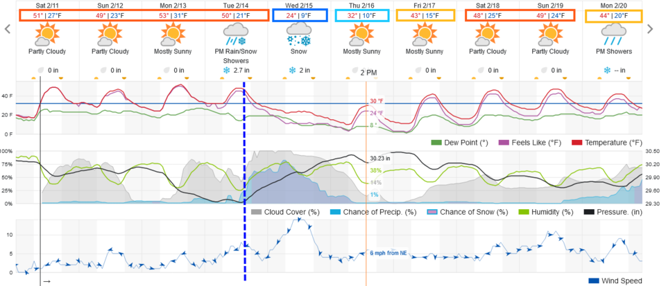
If you look at the end of the 10 day windows (Figure 1) there is a hint of another big-ish storm.  The GFS doubles the snow totals across the region bringing that in.

figure2_02112023
Figure 2: the 500mb upper air jet stream forecast map for Wednesday morning from the GFS and tropicaltidbits.com
figure3_02112023
Figure 3: the future surface pressure and precipitation map for Wednesday morning from the GFS and tropicaltidbits.com
figure4_02112023
Figure 4: the 10:1 snowfall ratio forecast from the GFS and weather5280 and the GFS through Thursday morning.
figure5_02112023
Figure 5: the 10:1 snowfall ratio forecast for the next 10 days from weather5280 and the GFS.


About the Author: John Ensworth

John Ensworth used to work from Longmont as the PI for the NASA through the IGES (The Institute for Global Environmental Strategies). He now teaches technology, algebra, astronomy, meteorology, film school, and Lego robotics to middle/high school.
Read more


Comments


Current Weather

Sunny

Sunny

82°F

UV Index
7 High
Pressure
30.31 Steady
Visibility
20 miles
Dewpoint
57 °F
Humidity
42%
Wind
NE 1.6 mph
Gust
5.9 mph
Wind Chill
82 °F

Hourly Forecast

Today
12 PM
87°F
Sunny
Today
1 PM
91°F
Mostly sunny
Today
2 PM
94°F
Mostly sunny
Today
3 PM
96°F
Mostly sunny
Today
4 PM
98°F
Mostly sunny
Today
5 PM
97°F
Mostly sunny
Today
6 PM
95°F
Mostly sunny
Today
7 PM
91°F
Mostly sunny
Today
8 PM
87°F
Clear
Today
9 PM
82°F
Clear
Today
10 PM
78°F
Clear
Today
11 PM
73°F
Clear

7 Day Forecast

Sunny

Wednesday

98 °F

Hot with the temperature approaching the record of 99 set in 2013 with plenty of sunshine


Clear

Wednesday Night

59 °F

Clear


Partly sunny

Thursday

98 °F

Hot with sunshine mixing with some clouds; danger of dehydration and heatstroke if outside for extended periods of time


Intermittent clouds

Thursday Night

63 °F

Partly cloudy


Mostly cloudy

Friday

84 °F

Clouds and breaks of sun with a thunderstorm in spots in the afternoon


Intermittent clouds

Friday Night

59 °F

A thunderstorm in spots in the evening; otherwise, partly cloudy


Mostly cloudy

Saturday

77 °F

Rather cloudy with a thunderstorm around in the afternoon


Mostly clear

Saturday Night

58 °F

Mainly clear


Thunderstorms

Sunday

73 °F

Mainly cloudy with a thunderstorm or two in the afternoon


Cloudy

Sunday Night

57 °F

Overcast with a thunderstorm around late


Sunrise and Sunset

Sunrise
6:16 AM
Sunset
7:51 PM

Based on AccuWeather data