Skip to content

Thur Update: The Front Range Forecast: A quiet week ahead

In Brief:

Quiet weather for the week to come.

Thursday update:

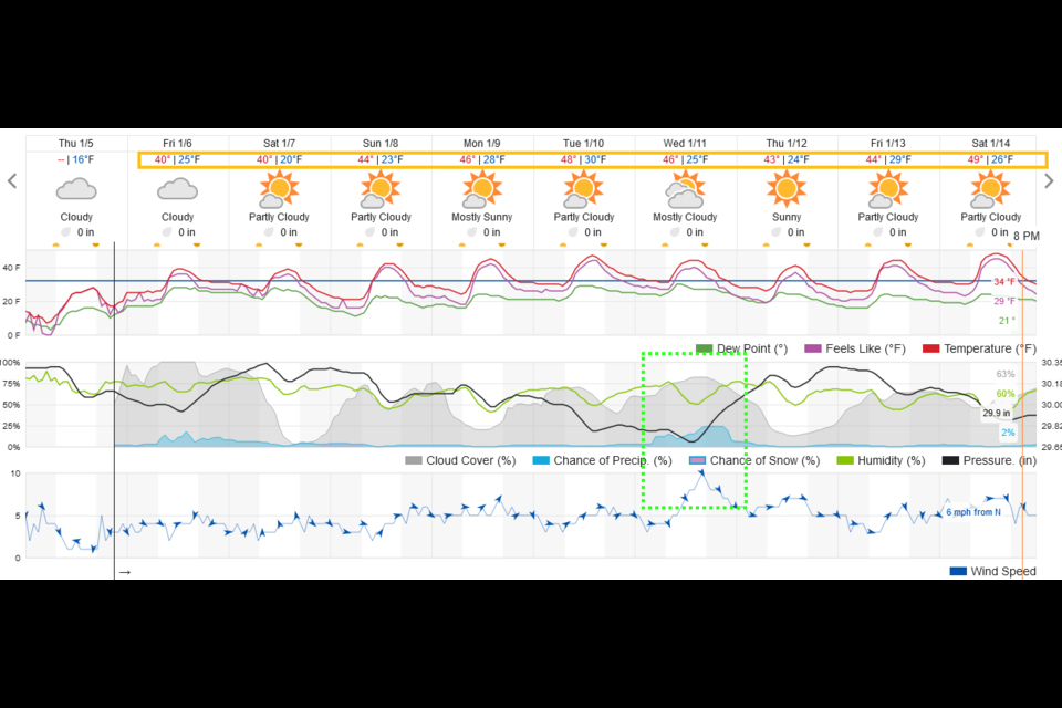
The last storm under performed on my forecast.  Longmont received about 1.5 inches of snow over 36 hours.  The week ahead looks very quiet even as snow storm after snow storm hits the western slopes (great news!). Temperatures stay around seasonable normal for that time as well (Figure 1 update). There now is a small chance of rain/snow around the 11th.  We'll see!

figure1u_01052023
Figure 1 update: the 10 day graphical forecast from weatherunderground.com

End Thursday update.

Forecast Discussion:

Winter Storm Watch
Issued: 1:24 PM Dec. 31, 2022 – National Weather Service

...WINTER STORM WATCH IN EFFECT FROM LATE SUNDAY NIGHT THROUGH
MONDAY EVENING...

* WHAT...Heavy snow possible. Total snow accumulations between 2 and
5 inches possible. Winds could gust as high as 35 mph.

* WHERE...Portions of east central, north central, and northeast
Colorado.

* WHEN...From late Sunday night through Monday evening.

* IMPACTS...Travel may become very difficult to impossible due to
heavy snowfall on roadways. Plan on slippery road conditions. The
hazardous conditions could impact the Monday morning and evening
commutes.

PRECAUTIONARY/PREPAREDNESS ACTIONS...

Monitor the latest forecasts for updates on this situation.

________________________________________

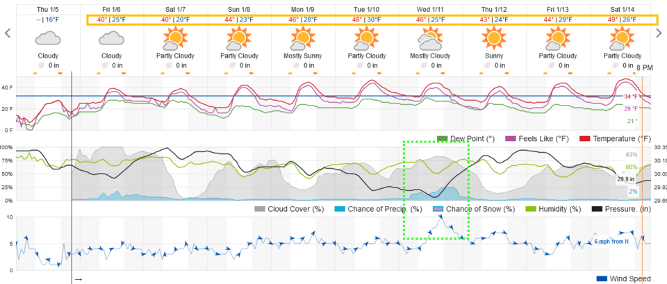
We will see a high of around 50 Saturday/New Year's eve (Figure 1).

New Years Midnight Forecast: It will be around 31F at the stroke of midnight. Skies will be mostly cloudy winds will be light south or southwest winds and a negligible chance of precipitation.

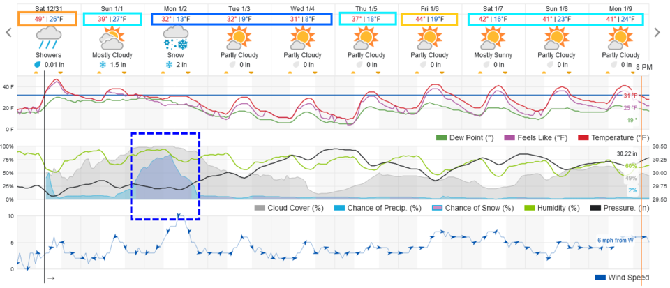
Then we turn our attention to the next storm system. This too is a not-so-cold Pacific front with lots of moisture. The current expected track of the low is really good for I-25 and foothills snow (Figure 2). This last storm way over performed giving much of the Front Range south of Fort Collins 6-12 inches.  This could happen again. Precipitation may start as rain again (lower chance than last time) Sunday late afternoon changing to snow that should last through Monday afternoon. 

Snowfall Roundup:

I'm giving Longmont to Broomfield 3-5 inches.

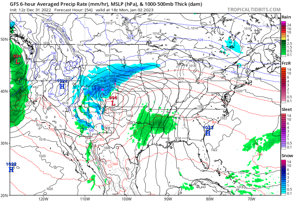
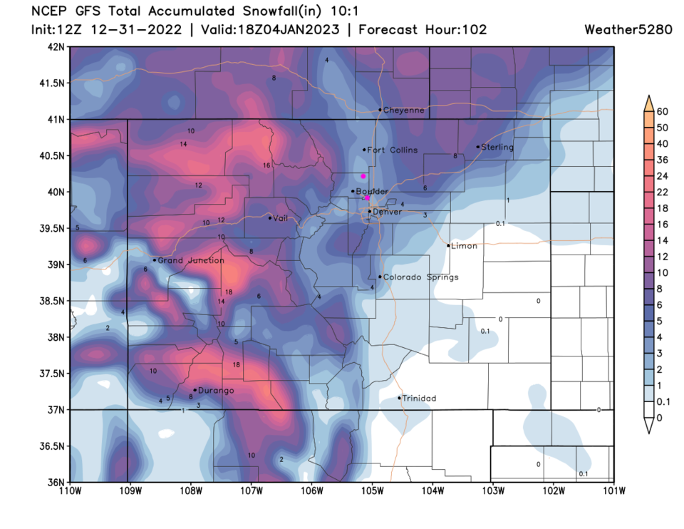
The GFS gives this area paints 2-5 inches (Figure 3).

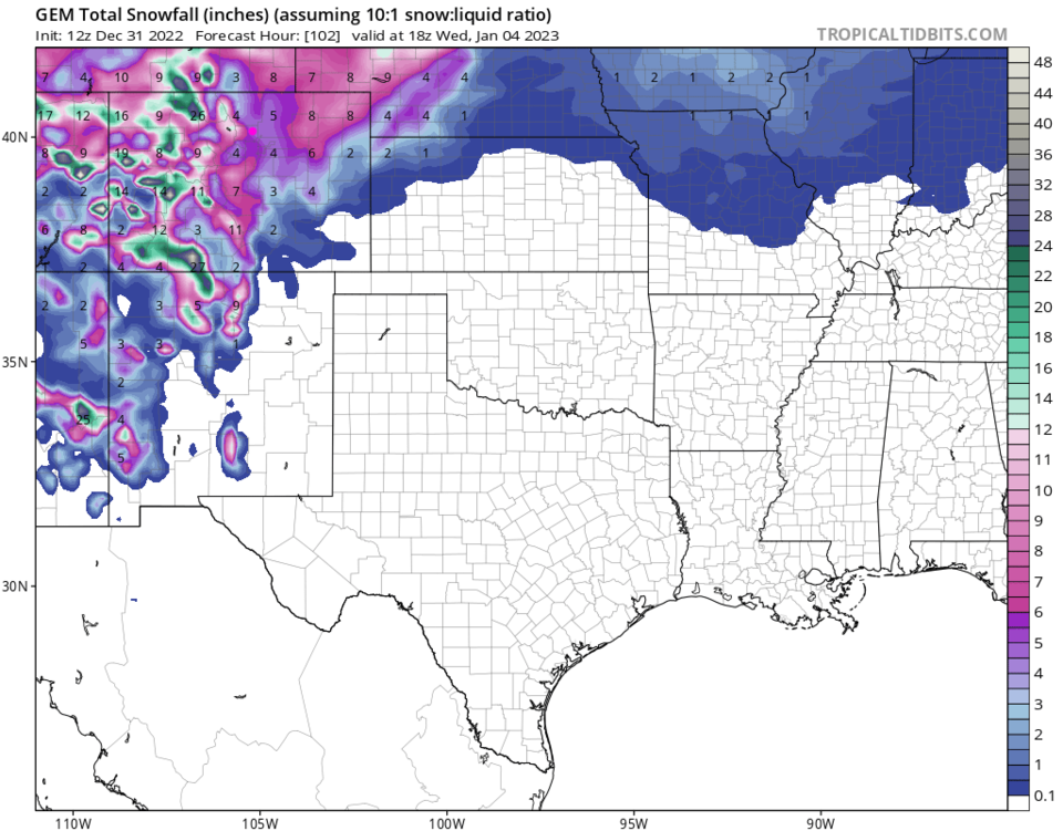
The Canadian gives this area 3-6 inches (Figure 4).

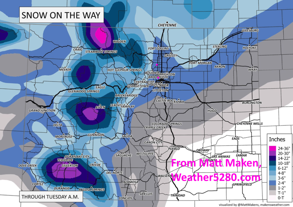
Weather5280's Matt Maken predicts 2-5 inches (Figure 5).

Channel 7 news gives 2-4 inches (not shown).

Channel 9 (and the EURO model - not shown) gives 3-5 inches.

figure1_12312022
Figure 1: the 10 day graphical forecast for Denver from weatherunderground.com
figure2_12312022
Figure 2: the 6 hour surface precipitation map for midday Monday from the GFS and tropicaltidbits
figure3_12312022
Figure 3: the snowfall total through noon January 4 from the GFS and weather5280.com
figure4_12312022
Figure 4: the snowfall total through January 4 from the Canadian model and tropicaltidbits.
figure5_12312022
Figure 5: the snowfall total map created by Matt Maken weather5280.com

The Longer Range Forecast:

We stay cool through the end of the week after this storm with a warm-up to normal temperatures by Friday. Quiet weather is the story for the rest of the 10 day period.


About the Author: John Ensworth

John Ensworth used to work from Longmont as the PI for the NASA through the IGES (The Institute for Global Environmental Strategies). He now teaches technology, algebra, astronomy, meteorology, film school, and Lego robotics to middle/high school.
Read more


Comments


Current Weather

Cloudy

Cloudy

49°F

UV Index
0 Low
Pressure
29.61 Falling
Visibility
8 miles
Dewpoint
44 °F
Humidity
81%
Wind
SSW 2.3 mph
Gust
5 mph
Wind Chill
49 °F

Hourly Forecast

Today
5 AM
51°F
Cloudy
Today
6 AM
51°F
Cloudy
Today
7 AM
52°F
Cloudy
Today
8 AM
55°F
Cloudy
Today
9 AM
60°F
Cloudy
Today
10 AM
62°F
Thunderstorms
Today
11 AM
65°F
Cloudy
Today
12 PM
68°F
Cloudy
Today
1 PM
67°F
Thunderstorms
Today
2 PM
70°F
Mostly cloudy
Today
3 PM
68°F
Mostly cloudy
Today
4 PM
67°F
Mostly cloudy

7 Day Forecast

Thunderstorms

Friday

70 °F

Mostly cloudy with a couple of thundershowers


Thunderstorms

Friday Night

45 °F

Cloudy with a couple of thundershowers


Rain

Saturday

48 °F

Chilly with periods of rain and a thunderstorm; travel in the foothills and mountains will be slippery due to snow


Rain and snow

Saturday Night

39 °F

Cloudy with rain, mixed with a little snow late; travel in the foothills and mountains will be slippery due to snow


Mostly cloudy

Sunday

59 °F

Mostly cloudy and warmer


Partly cloudy

Sunday Night

36 °F

Partly cloudy


Partly sunny

Monday

71 °F

Partly sunny, pleasant and warmer


Partly cloudy

Monday Night

45 °F

Partly cloudy


Mostly sunny

Tuesday

73 °F

Pleasant with sunshine and patchy clouds


Partly cloudy

Tuesday Night

43 °F

Partly cloudy


Sunrise and Sunset

Sunrise
6:06 AM
Sunset
7:51 PM

Based on AccuWeather data