Skip to content
Join our Newsletter

Mon Update: The Front Range Forecast: Hot, dry summer weather

In Brief:

A ridge builds overhead and we get a taste of hot, dry summer weather.  Thunderstorms will return.

Monday Update:

Interesting climatology from the National Weather Service. BUT - DIA only made it to 87F today.

High temperatures are expected reach the 90-degree mark in Denver for the first time this year. The last 90-degree day last year occurred on 9/20/2022, 272 days ago. Our first 90-degree day last year occurred on 5/11/2022. By this time last year, Denver had reached 90 degrees for the 10th time. In the mountains,
expect gusty west to southwest winds this afternoon, with gusts 35-50 mph possible at times above timberline.

End Monday update.

The Forecast Discussion:

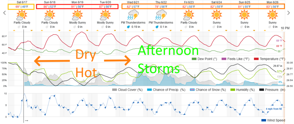
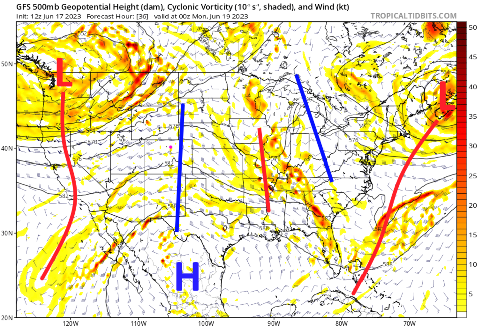
We have a ridge, finally, building over the state starting Sunday (Figure 2). This will give us our first good chance of 90F+ weather! (Figure 1)  We see quiet weather in the southwest and intermountain West (Figure 2).

figure1_06172023
Figure 1: the 10 day graphical forecast for Denver from weaatherunderground.com
figure2_06172023
Figure 2: the 500mb upper air forecast map for Sunday night from the GFS and tropicaltidbits.com
figure3_06172023
Figure 3: the Sunday forecast surface map from the NWS

The Longer Range Forecast:

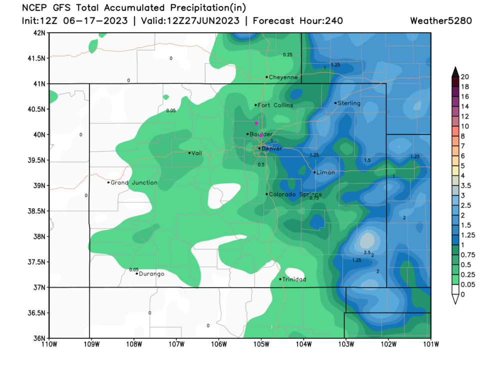
Starting Wednesday, moisture returns and afternoon storm chances pick up again (Figure 1). Over the next 10 days, the rain is mainly confined to the eastern Plains of Colorado (Figure 4).

figure4_06172023
Figure 4: the 10 day GFS rainfall forecast from weather5280.com


About the Author: John Ensworth

John Ensworth used to work from Longmont as the PI for the NASA through the IGES (The Institute for Global Environmental Strategies). He now teaches technology, algebra, astronomy, meteorology, film school, and Lego robotics to middle/high school.
Read more


Comments


Current Weather

Clear

Clear

74°F

UV Index
0 Low
Pressure
29.7 Rising
Visibility
9 miles
Dewpoint
31 °F
Humidity
21%
Wind
SSW 4 mph
Gust
9.3 mph
Wind Chill
74 °F

Hourly Forecast

Today
1 AM
72°F
Clear
Today
2 AM
69°F
Clear
Today
3 AM
67°F
Clear
Today
4 AM
65°F
Clear
Today
5 AM
63°F
Clear
Today
6 AM
61°F
Sunny
Today
7 AM
66°F
Sunny
Today
8 AM
73°F
Sunny
Today
9 AM
80°F
Sunny
Today
10 AM
84°F
Sunny
Today
11 AM
88°F
Sunny
Today
12 PM
91°F
Sunny

7 Day Forecast

Hot

Friday

100 °F

Sunny to partly cloudy and very hot with the temperature approaching the record of 101 set in 1989; caution advised if outside for extended periods of time


Clear

Friday Night

61 °F

Clear and mild


Sunny

Saturday

99 °F

Hot with plenty of sunshine; gusty winds, low humidity and dry brush result in a high fire threat


Clear

Saturday Night

62 °F

Clear and mild


Mostly sunny

Sunday

93 °F

Sunny to partly cloudy and very warm; breezy in the afternoon; gusty winds, low humidity and dry brush result in a high fire threat


Mostly clear

Sunday Night

54 °F

Mainly clear with a thunderstorm in parts of the area; breezy in the evening


Mostly cloudy

Monday

77 °F

Mostly cloudy and cooler


Thunderstorms

Monday Night

55 °F

Mostly cloudy with a couple of showers and a thunderstorm, mainly early


Intermittent clouds

Tuesday

80 °F

Pleasant with intervals of clouds and sunshine


Mostly cloudy

Tuesday Night

60 °F

Turning cloudy in the evening followed by late-night low clouds


Sunrise and Sunset

Sunrise
5:31 AM
Sunset
8:33 PM

Based on AccuWeather data