Skip to content
Join our Newsletter

Sunday Update: The Front Range Forecast: Extreme cold + snow

In Brief:

Chilly weather turning cold Wednesday, small chance of a White Christmas.

Sunday Update:

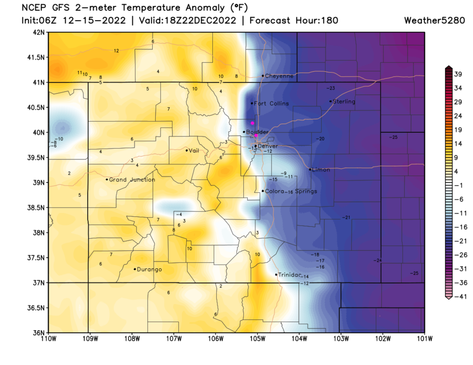
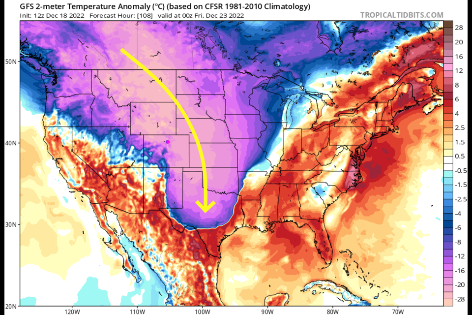
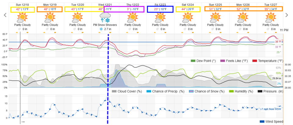
Just a quick reminder that a powerful cold front is on its way for about sunset Wednesday (Figure 1 update).  We'll see some snow from this system as well, but temperatures might drop as low as -15 to -20 on the Plains with this one (Figure 2 update). Snow won't be the main focus of this storm, but with temperatures that low, we'll see higher snowfall ratios (water content to fluff depth).  More 15:1 than 10:1.  This might give I-25 locations 3-5 inches.   More later!

figure1u_12182022
Figure 1 update: the 10 day graphical forecast for Denver from weatherunderground.com
figure2u_12182022
Figure 2 update: the surface temperature anomaly (departure from normal) for Thursday evening from the GFS and tropicaltidbits.com

End Sunday Update.

Forecast Discussion:

Temperatures remain below normal or just getting to normal for the next week. Clouds come and go but snow/rain is not expected along I-25 for six days (Figure 1).

figure1_12152022
Figure 1: the 10 day graphical forecast for Denver from weatherunderground.com

The Longer Range Forecast:

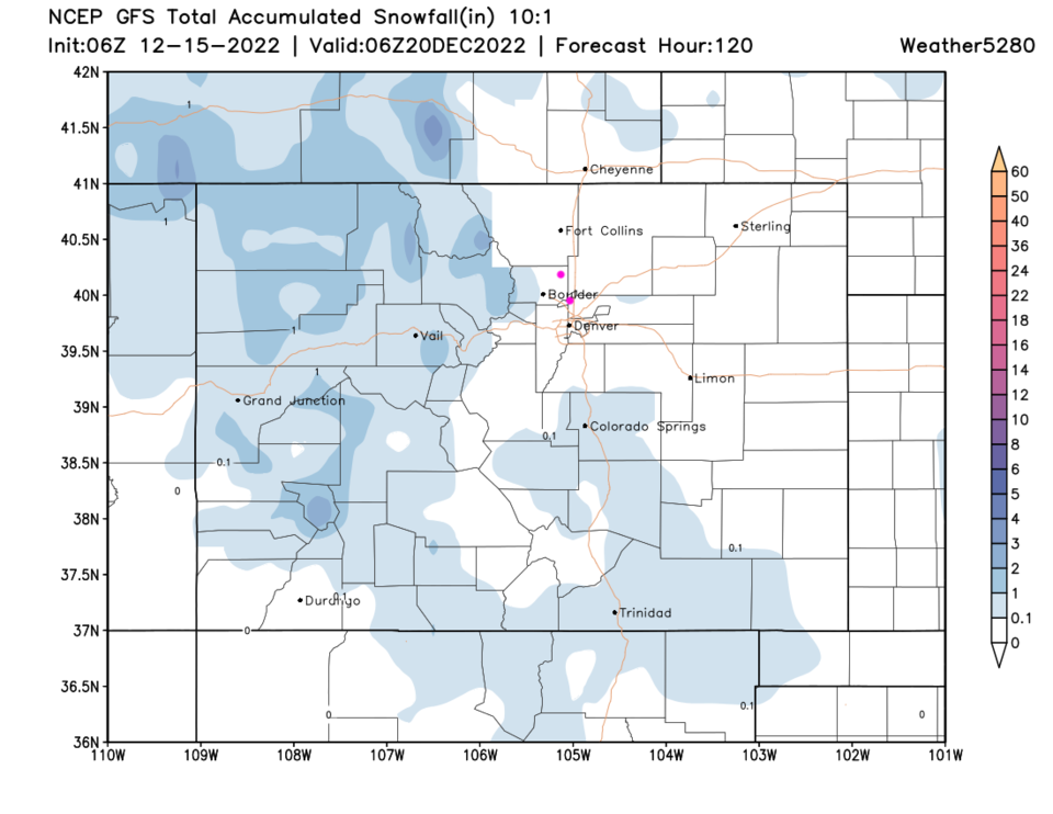
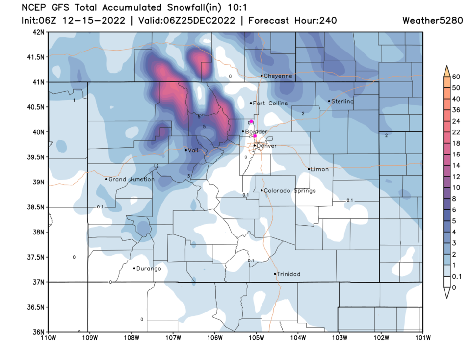
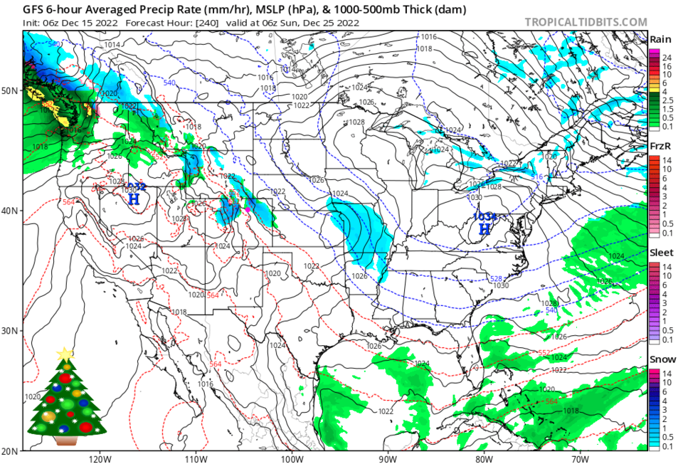
A strong cold front arrives Wednesday dropping temperatures to below freezing again (Figure 1 dotted line) but the shallow very cold air won't make it very high into the mountains (Figure 2). Snow over the next five days will be light and confined to mountain locations (Figure 3). Over the next 10 days (including Christmas) we'll see more northern mountain snows and snow out on the northeast plains (Figure 4). That doesn't look like much snow on the ground for Christmas, but there might be snow falling nearby on Christmas morning (Figure 5).  We'll keep an eye on it here!

figure2_12152022
Figure 2: the surface temperature anomaly (departure from normal) for Thursday
figure3_12152022
Figure 3: the 5 day (10:1 ratio) snowfall forecast from the GFS and weather5280.com
figure4_12152022
Figure 4: the 10 day (10:1 ratio) snowfall forecast from the GFS and weather5280.com
figure5_12152022
Figure 5: the surface map forecast for Christmas morning from the GFS and tropicaltidbits.com


About the Author: John Ensworth

John Ensworth used to work from Longmont as the PI for the NASA through the IGES (The Institute for Global Environmental Strategies). He now teaches technology, algebra, astronomy, meteorology, film school, and Lego robotics to middle/high school.
Read more


Comments


Current Weather

Sunny

Sunny

93°F

UV Index
5 Moderate
Pressure
30.18 Falling
Visibility
8 miles
Dewpoint
46 °F
Humidity
20%
Wind
ENE 3.3 mph
Gust
8.3 mph
Wind Chill
93 °F

Hourly Forecast

Today
4 PM
94°F
Intermittent clouds
Today
5 PM
95°F
Mostly cloudy
Today
6 PM
92°F
Cloudy
Today
7 PM
89°F
Cloudy
Today
8 PM
86°F
Partly sunny
Today
9 PM
82°F
Partly cloudy
Today
10 PM
79°F
Partly cloudy
Today
11 PM
76°F
Partly cloudy
Tomorrow
12 AM
73°F
Partly cloudy
Tomorrow
1 AM
72°F
Partly cloudy
Tomorrow
2 AM
70°F
Partly cloudy
Tomorrow
3 AM
68°F
Partly cloudy

7 Day Forecast

Mostly cloudy

Sunday

95 °F

Thickening clouds


Partly cloudy

Sunday Night

63 °F

Partly cloudy


Mostly cloudy w/ t-storms

Monday

93 °F

Some sunshine giving way to clouds with a thunderstorm in the area late in the afternoon; thunderstorms can bring hail and damaging winds


Partly cloudy w/ t-storms

Monday Night

59 °F

A thunderstorm in spots in the evening; otherwise, clear to partly cloudy; thunderstorms can bring hail and damaging winds


Intermittent clouds

Tuesday

94 °F

Intervals of clouds and sunshine


Partly cloudy

Tuesday Night

60 °F

Partly cloudy


Partly sunny w/ t-storms

Wednesday

84 °F

Not as warm with times of sun and clouds; an afternoon thunderstorm; thunderstorms can bring hail and damaging winds


Mostly cloudy

Wednesday Night

58 °F

An evening thunderstorm; otherwise, mostly cloudy


Cloudy

Thursday

89 °F

Cloudy with a thunderstorm in spots in the afternoon


Intermittent clouds

Thursday Night

58 °F

Partly cloudy


Sunrise and Sunset

Sunrise
5:42 AM
Sunset
8:30 PM

Based on AccuWeather data