Skip to content
Join our Newsletter

Tue Update: The Front Range Forecast: Snow on the horizon

figure1u_11012022
Figure 1 update: the NWS surface forecast map for Friday AM.

In Brief:

Warm weather holds through Wednesday, then rain and an inch or more of snow along I-25.

Tuesday update:

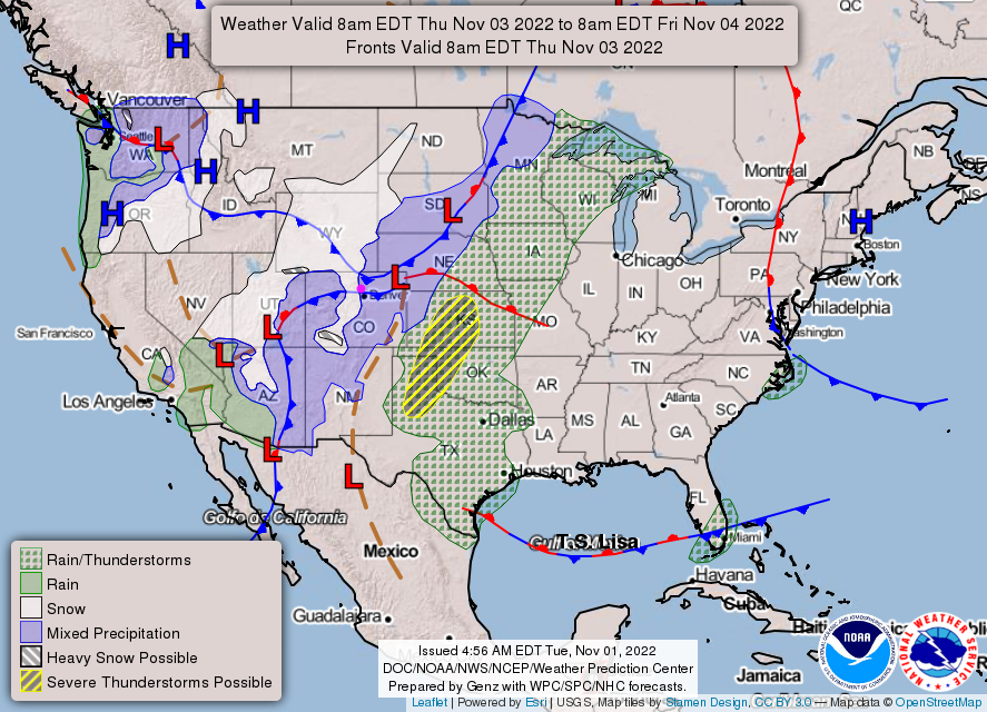
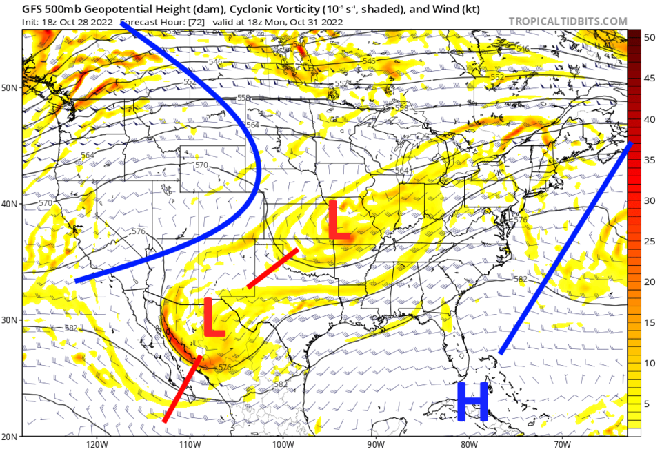
The National Weather Service forecast map for Friday AM (Figure 1 update) shows Snow (or at least a rain/snow mix) for almost all of Colorado. The first cold front begins the temperature slide around 2pm on Wednesday (Figure 2 update). A reinforcing shot of cold air lets temperatures to drop a bit further and starts the precipitation. If we get snow, it looks like rain changes to snow around midnight or a bit later Friday morning.  Snow (or a rain/snow mix) should come to an end around sunrise.  It is not a big window where we have both precipitation and cold enough temperatures for much snow.

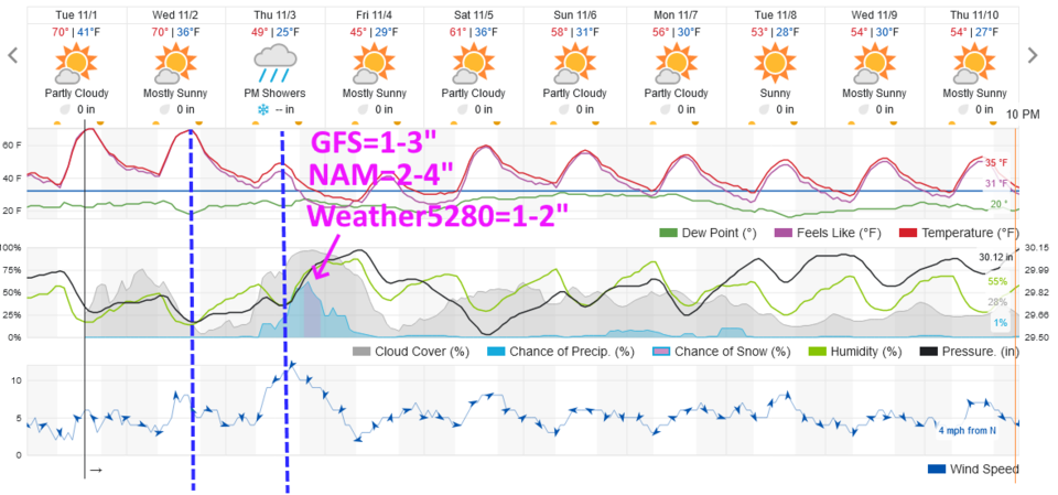
Figure 2 update shows the GFS giving Longmont/Broomfield 1-3 inches, the North American Model (NAM) gives these places 2-4 inches.  The forecasters at Weather5280.com gives us 1-2 inches.

figure1u_11012022
Figure 1 update: the NWS surface forecast map for Friday AM.
figure2u_11012022
Figure 2 update: the 10 day graphical forecast for Denver from weatherunderground.com

End Tuesday update.

The Forecast Discussion:

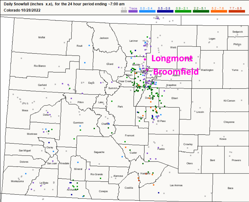
We had snow!  Well, there were reports of a rain/snow mix in Longmont and a trace of snow observed in Broomfield. Locations along the Front Range and I-25 corridor did see a healthy amount of snow (see green and orange dots in Figure 1).

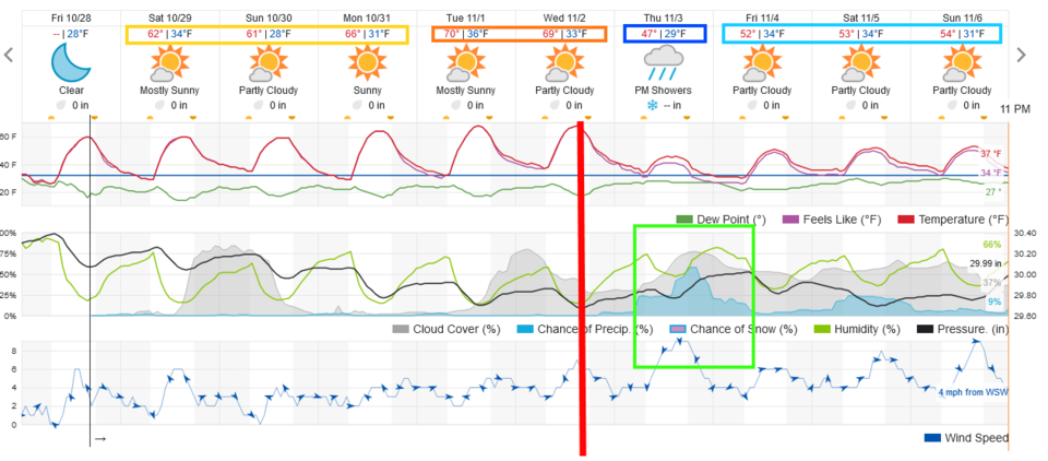
The week ahead will be quiet with comfortable high temperatures through Wednesday (Figure 2). Even nighttime temperatures will remain close to freezing. To see our next storm chances, check out the Longer Range Forecast below.

HALLOWEEN forecast:

Temperatures on Halloween night will start off 5pm at 63F. The temperature will drop to 48F by 8pm. Winds will be light at 5mph from the west with clear skies.  I plan to have my observatory open for Trick or Peek at the corner of Cherrywood Dr. and Cherrywood Way.

figure1_10282022
Figure 1: the 24 hour snowfall report through 7am Friday from CoCoRaHS.
figure2_10282022
Figure 2: the 10 day graphical forecast for Denver from weatherunderground.
figurer4_10282022
Figure 3: The 500mb upper air map for Monday noon from tropicaltidbits.com

The Longer Range Forecast:

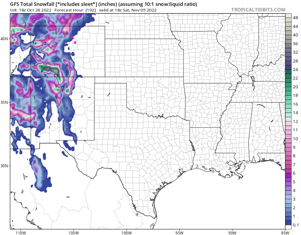
The next cold front arrives Wednesday (red line) with a rain and/or snow arriving mainly on Thursday (Figure 2). The snowfall map through Saturday seems to indicate that much of the I-25 folks and the mountains will see snow again.  More later!

figure3_10282022
Figure 4: the snowfall total through Saturday noon from tropicaltidbits and the GFS.


About the Author: John Ensworth

John Ensworth used to work from Longmont as the PI for the NASA through the IGES (The Institute for Global Environmental Strategies). He now teaches technology, algebra, astronomy, meteorology, film school, and Lego robotics to middle/high school.
Read more


Comments


Current Weather

Sunny

Sunny

71°F

UV Index
8 Very High
Pressure
30.16 Falling
Visibility
15 miles
Dewpoint
52 °F
Humidity
52%
Wind
SE 2.7 mph
Gust
4.3 mph
Wind Chill
71 °F

Hourly Forecast

Today
11 AM
71°F
Mostly sunny
Today
12 PM
74°F
Partly sunny
Today
1 PM
77°F
Partly sunny
Today
2 PM
79°F
Partly sunny
Today
3 PM
80°F
Mostly sunny
Today
4 PM
82°F
Mostly sunny
Today
5 PM
84°F
Mostly sunny
Today
6 PM
83°F
Sunny
Today
7 PM
79°F
Sunny
Today
8 PM
76°F
Sunny
Today
9 PM
71°F
Clear
Today
10 PM
66°F
Clear

7 Day Forecast

Mostly sunny

Wednesday

84 °F

Mostly sunny, pleasant and warmer; a big warmup is on the way later this week


Clear

Wednesday Night

53 °F

Clear


Mostly sunny

Thursday

95 °F

Sunny to partly cloudy and hot; caution advised if doing strenuous activities outside


Clear

Thursday Night

59 °F

Clear


Hot

Friday

102 °F

Sunny to partly cloudy and very hot with the temperature breaking the record of 101 set in 1989; first day of intense heat


Clear

Friday Night

60 °F

Clear


Hot

Saturday

101 °F

Blazing sunshine and very hot with the temperature approaching the record of 103 set in 2016; check on groups more sensitive to extreme heat


Clear

Saturday Night

62 °F

Clear and mild


Mostly sunny

Sunday

91 °F

Sunny to partly cloudy; breezy in the afternoon


Mostly clear

Sunday Night

61 °F

Breezy in the evening; otherwise, mainly clear


Sunrise and Sunset

Sunrise
5:31 AM
Sunset
8:32 PM

Based on AccuWeather data