Skip to content
Join our Newsletter

Fri Update:The Front Range Forecast: Cool with storms; then summer

In Brief:

Cool with storms, a return to normal summer weather in a few days.

Friday Update:

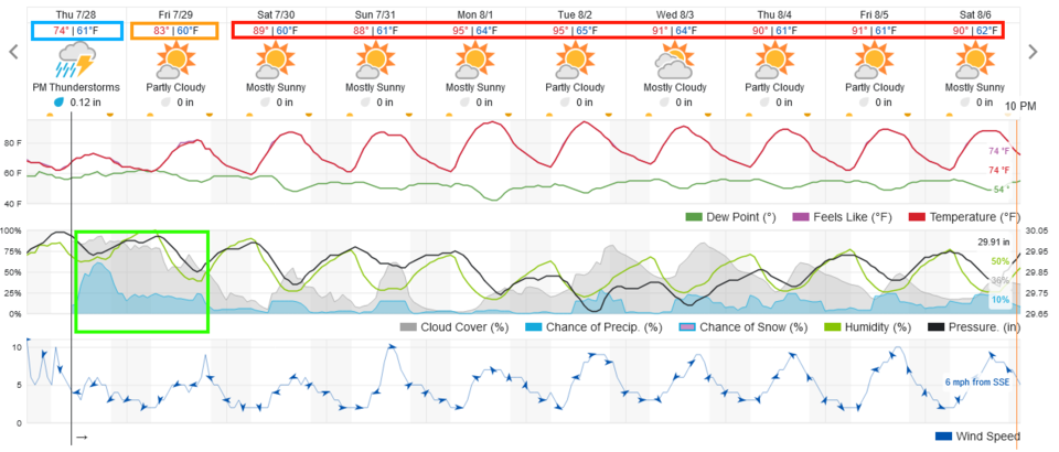
The weather situation today is very similar to yesterday (Thursday).  Storms, for the most part, did not materialize as too much cool, stabilizing air invaded northern Colorado. We are going to get warmer today but moisture levels are a touch lower. Storms that do form this afternoon could drop locally heavy, flooding rains.

End Friday update.

The Forecast Discussion:

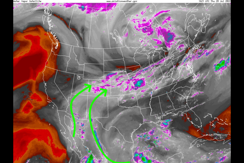
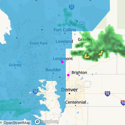
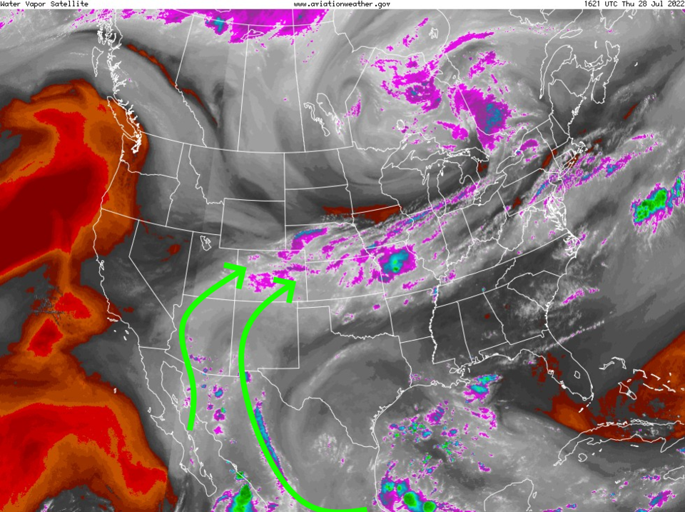
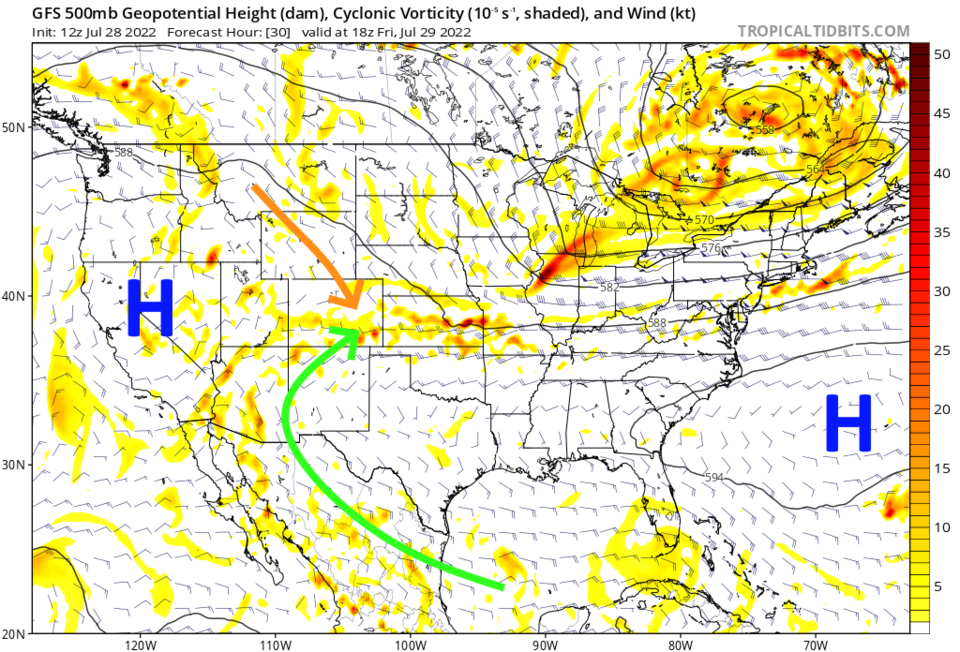
First, there is so much moisture in place (Figure 3) and with northwest flow aloft —excellent for creating repeated batches of thunderstorms day and night (Figure 4) — the National Weather Service has issued a Flash Flood Watch (Figure 1). Note, there is ALSO a Marginal Risk (1 on a scale of 1-5) for damaging thunderstorm winds and large hail for the Front Range and I-25 corridor.

Issued: 8:53 AM Jul. 28, 2022 – National Weather Service

...FLOOD WATCH IN EFFECT THROUGH THIS EVENING...

* WHAT...Flash flooding caused by excessive rainfall is possible.

* WHERE...Urban corridor north of the Palmer Divide and west of
I-25, and northwest Weld County.

* WHEN...Through 10 PM this evening (Thursday).

* IMPACTS...Excessive runoff may result in flooding of rivers,
creeks, streams, and other low-lying and flood-prone locations.
Flooding may occur in poor drainage and urban areas. Extensive
street flooding and flooding of creeks and rivers are possible.

* ADDITIONAL DETAILS...
- Up to 3 inches of rain has fallen in parts of Larimer and
Boulder Counties and additional heavy rainfall is expected.

_________________________________________________________________

We are very cool for this time of year Thursday and even Friday (Figure 2).  This is also due to the proximity of the trough to our east and a northern component of the airflow (Figure 4).  A serious ribbon of moisture continues over the southwestern and central United States (Figure 3 - grey/white shades).

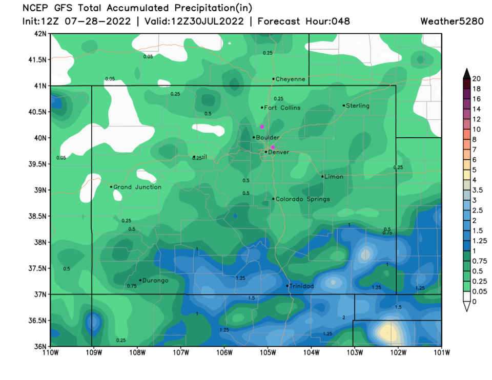
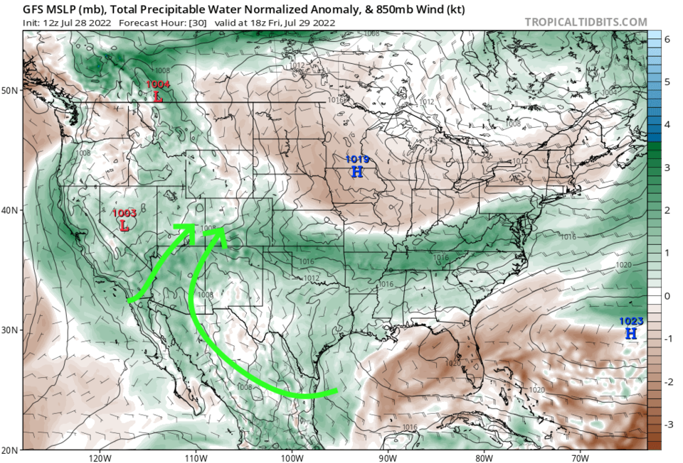
This moisture will remain in place Friday as well (green shading Figure 5). After that, a high-pressure center — currently over California (Figure 4) — will return to Colorado and give us a break from storms (mostly) Saturday through Monday.

Figure1_07282022
Figure 1: flash flood area in shading from the NWS.
Figure2_07282022
Figure 2: the 10 day graphical forecast for Denver from weatherunderground
Figure3_07282022
Figure 3: the water vapor satellite image from the NWS.
Figure4_07282022
Figure 4: the 500mb upper air map from tropicaltidbits.com and the GFS for Friday noon.
Figure5_07282022
Figure 5: the precipitatable water map from tropicaltidbits.com and the GFS for Friday noon.

The Longer Range Forecast:

For the remainder of next week, temperatures stay really close to normal with a return to daily chances of afternoon storms (Figure 2). The 3 day precipitation expectation around Longmont to Broomfield is about 1/4th to 1/2 inch of rain.  IF you get hit by a storm cell, you might see 1-2 inches in a short period of time.

Figure6_07282022
Figure 6: the 3 day precipitation total from the GFS and weather5280.com


About the Author: John Ensworth

John Ensworth used to work from Longmont as the PI for the NASA through the IGES (The Institute for Global Environmental Strategies). He now teaches technology, algebra, astronomy, meteorology, film school, and Lego robotics to middle/high school.
Read more


Comments


Current Weather

Mostly cloudy

Mostly cloudy

80°F

UV Index
0 Low
Pressure
30.21 Rising
Visibility
8 miles
Dewpoint
53 °F
Humidity
39%
Wind
NNE 2.4 mph
Gust
5.2 mph
Wind Chill
80 °F

Hourly Forecast

Today
11 PM
76°F
Mostly cloudy
Tomorrow
12 AM
73°F
Partly cloudy
Tomorrow
1 AM
72°F
Partly cloudy
Tomorrow
2 AM
70°F
Partly cloudy
Tomorrow
3 AM
68°F
Partly cloudy
Tomorrow
4 AM
66°F
Partly cloudy
Tomorrow
5 AM
65°F
Partly cloudy
Tomorrow
6 AM
63°F
Mostly sunny
Tomorrow
7 AM
65°F
Mostly sunny
Tomorrow
8 AM
70°F
Mostly sunny
Tomorrow
9 AM
75°F
Mostly sunny
Tomorrow
10 AM
81°F
Partly sunny

7 Day Forecast

Mostly cloudy

Sunday

93 °F

Thickening clouds


Intermittent clouds

Sunday Night

63 °F

An evening shower in places; otherwise, becoming clear


Mostly cloudy w/ t-storms

Monday

93 °F

Some sunshine giving way to clouds with a thunderstorm in the area late in the afternoon; thunderstorms can bring hail and damaging winds


Partly cloudy w/ t-storms

Monday Night

59 °F

A thunderstorm in spots in the evening; otherwise, clear to partly cloudy; thunderstorms can bring hail and damaging winds


Intermittent clouds

Tuesday

94 °F

Intervals of clouds and sunshine


Partly cloudy

Tuesday Night

60 °F

Partly cloudy


Partly sunny w/ t-storms

Wednesday

84 °F

Not as warm with times of sun and clouds; an afternoon thunderstorm; thunderstorms can bring hail and damaging winds


Mostly cloudy

Wednesday Night

58 °F

An evening thunderstorm; otherwise, mostly cloudy


Mostly cloudy

Thursday

89 °F

Mostly cloudy with a thunderstorm in spots in the afternoon


Intermittent clouds

Thursday Night

58 °F

Partly cloudy


Sunrise and Sunset

Sunrise
5:42 AM
Sunset
8:30 PM

Based on AccuWeather data