In Brief:
A quick warm up begins.
Friday Update:
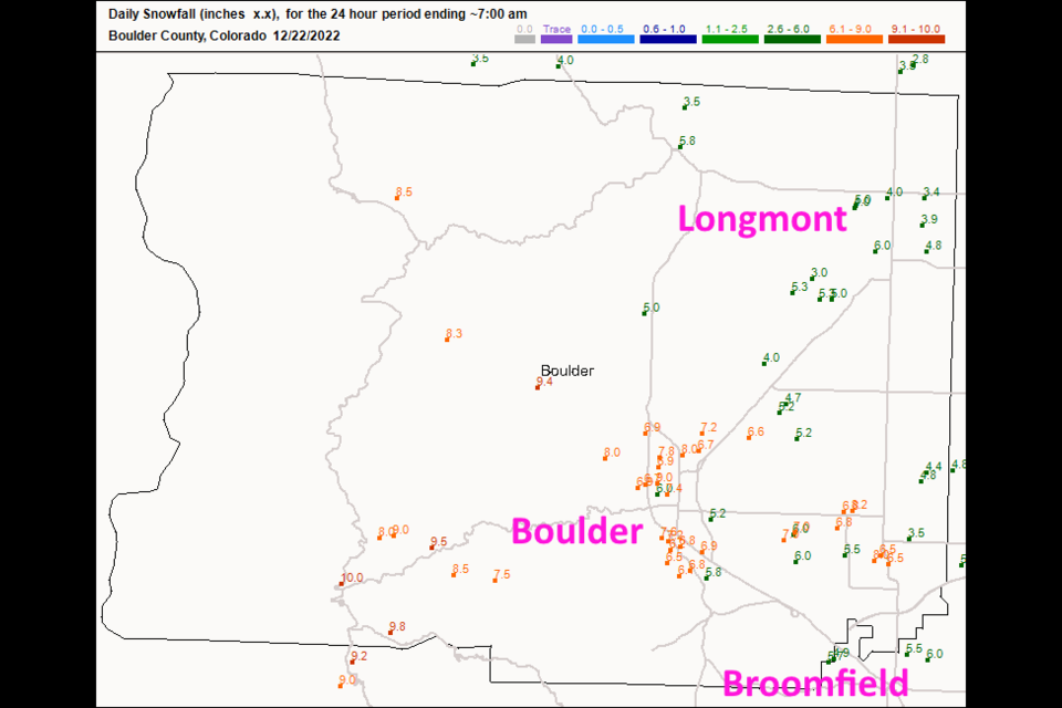
The storm delivered all the cold air promised, and all the promised snow and more. Boulder County received the greatest snow totals (Figure 2 update). Areas around Longmont picked up 3-6 inches (my forecast was 2-4). Boulder got 5-9 inches with communities to the west picking up 10 inches.
The wind chill warning expires 11am Friday. We warm up to above normal temperatures quickly over the next couple of days. Our next chance of winter weather seems to come along around Wednesday next week. I'll keep you updated!
End Friday update.
Wednesday Update.
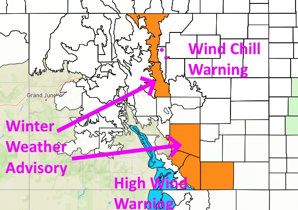
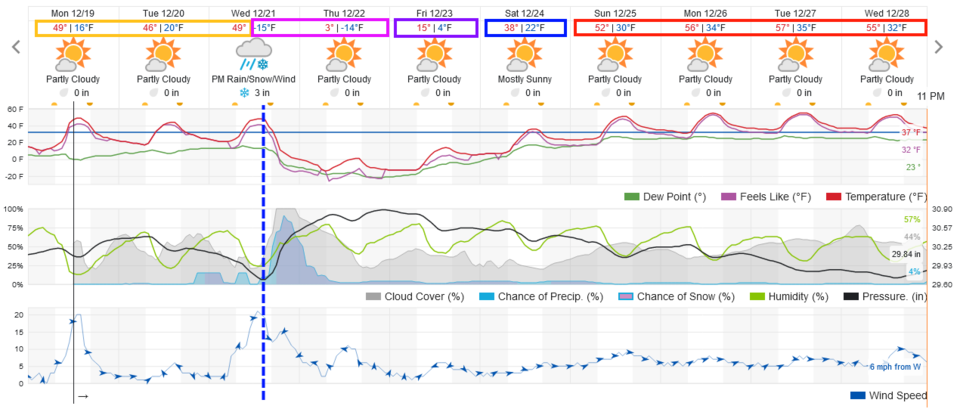
The forecast is on track. The wind shift and front should hit a bit earlier than anticipated, between 2 and 3pm. Temperatures will be 53 at noon, 38 by 4pm, 19 by 6pm, 9F by 8pm and 0F by midnight. Not the fastest or biggest drop ever, but really impressive. Longmont to Broomfield are on track for about 2-4 inches of powder overnight. The highlight is the cold temperatures and very low wind chills due to strong winds. The NWS has issued the following wind chill warning (Figure 1 update):
Wind Chill Warning
Issued: 5:12 AM Dec. 21, 2022 – National Weather Service
...WINTER WEATHER ADVISORY REMAINS IN EFFECT FROM 4 PM THIS AFTERNOON TO 9 AM MST THURSDAY...
...WIND CHILL WARNING REMAINS IN EFFECT FROM 8 PM THIS EVENING TO 11 AM MST FRIDAY...
* WHAT...Snowfall accumulations between up to 3 inches. Winds gusting as high as 45 mph. Dangerously cold wind chills as low as 50 below zero.
* WHERE...The Front Range foothills, Palmer Divide and adjacent plains.
* WHEN...For the Winter Weather Advisory, from 4 PM this afternoon to 9 AM MST Thursday. For the Wind Chill Warning, from 8 PM this evening to 11 AM MST Friday.
* IMPACTS...Exposed skin may become quickly frostbitten or frozen. Wind chill values may fall to extremely dangerous levels. Plan on slippery road conditions. The hazardous conditions could impact the Wednesday evening and Thursday morning commutes. The
dangerously cold wind chills could cause frostbite on exposed skin in as little as 5 minutes.
PRECAUTIONARY/PREPAREDNESS ACTIONS...
The combination of wind and cold temperatures will create dangerously low wind chill values. Avoid outside activities if possible. When outside, make sure you wear appropriate clothing, a hat, and gloves. Slow down and use caution while traveling. The latest road conditions for Colorado can be obtained by calling 5 1 1 or by going to www.cotrip.org.
End Wednesday update.
The Forecast Discussion:
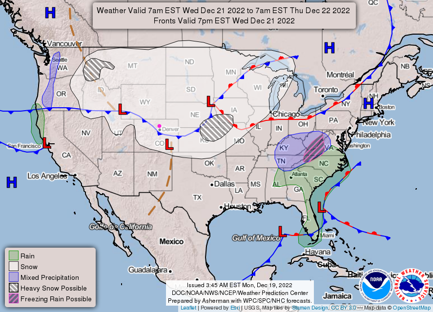
Enjoy the weather through Wednesday morning. We are going to get slapped with a very strong cold front Wednesday afternoon (Figure 1). The models suggest a late afternoon frontal passage, but fronts like these are often early.
The big story is the temperature. The National Weather Service (NWS) points out, in internal communications, that the Denver high temperature on Thursday may stick at -5F. They also have issued a wind chill watch. Wind chills on the Plains may approach -50F as well as up in the mountains. It may only feel as cold as -20 to -30F along I-25.
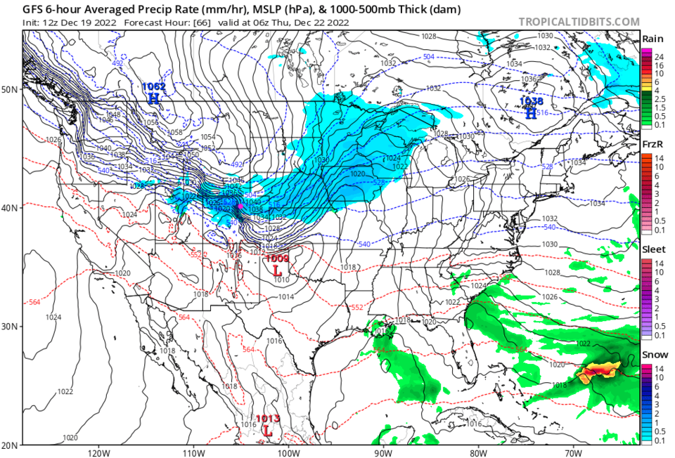
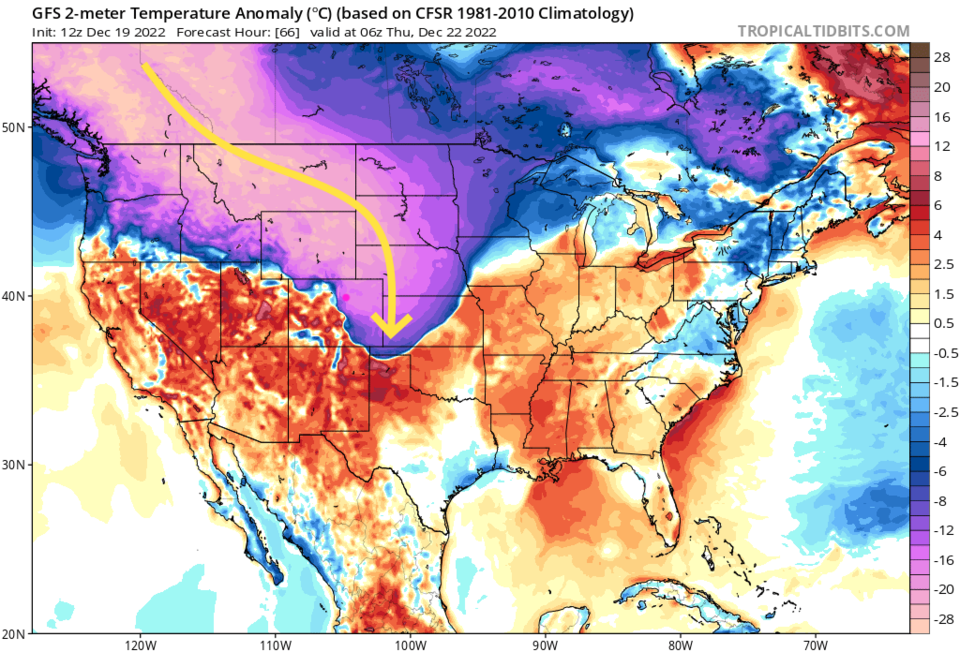
The surface map for Wednesday afternoon shows that front speeding down the Plains and across Colorado (Figure 2) with the GFS painting a band of snow across the north-central part of the state (Figure 3). The surface temperature departure from normal is astonishing with temperatures running -20 to -25 below normal (Figure 4).
Snowfall Roundup:
The snowfall will be light but very fluffy at these temperatures. I'm expecting a 15:1 ratio (15 inches of snow from 1 inch of water) rather than the more normal 8:1 (near or above freezing) or 10:1 (upper 20's).
I'm calling for 1-4" along I-25
The NWS says 1-3" on the Plains, foothills, and mountain Parks. 3-6 inches in the higher mountains, and up to 12 inches in "the Park, Rabbit Ears, and northern Front Ranges."
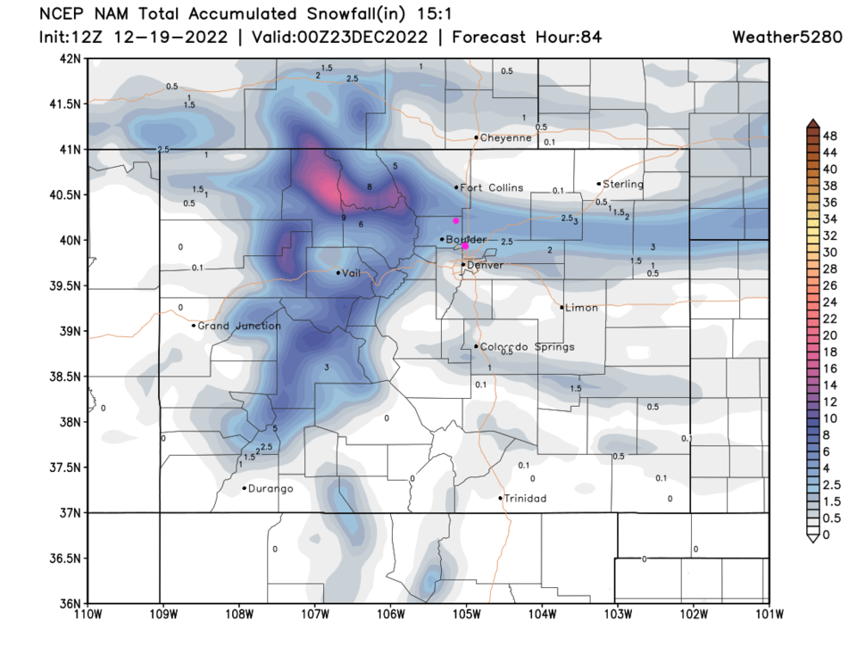
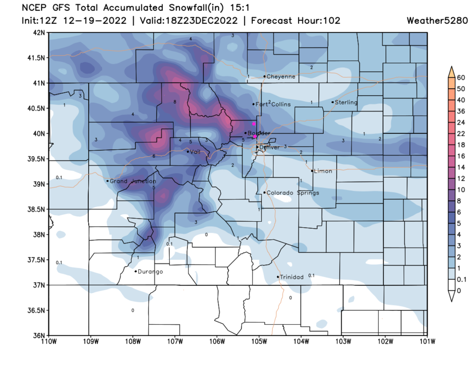
Again, both models, the NAM and GFS have a distinct band of snow across the northern mountains, Larimer and Boulder counties and out east. If this moves north or south, totals will change a lot for the cities.
For Longmont-Broomfield:
The NAM has 2-4 inches. (Figure 5)
The GFS 3-6 inches. (Figure 6)
The Accuweather model (not shown) 3-6 inches.
The Longer Range Forecast:
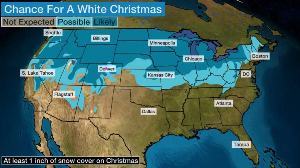
With temperatures only getting to the upper 30's on Christmas Eve (and briefly that long - Figure 1) - the snow that is on the ground should stick around for Christmas (if that is your definition of a White Christmas, some say snow must be falling, which will not happen). Figure 7 is a map from weatherunderground on their chances for snow to still be on the ground for Christmas morning. They put us in the Possible to Likely category.
For fun, there have been 33 White Christmases since 1921 in Denver. The last time we had snow on the ground it was 1 inch in 2017.
Christmas day is quite mild with highs in the lower 50's. We even approach the 60's early next week. This will end our long chilly period.
Merry Christmas!