Skip to content
Join our Newsletter

Thursday Update: The Front Range Forecast: Rain totals, a return to warm and dry conditions

In Brief:

Warm weather returns, rain takes a break again (except for maybe Sunday).

Thursday Update:

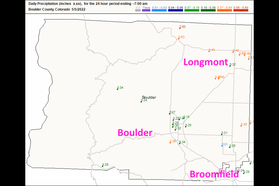
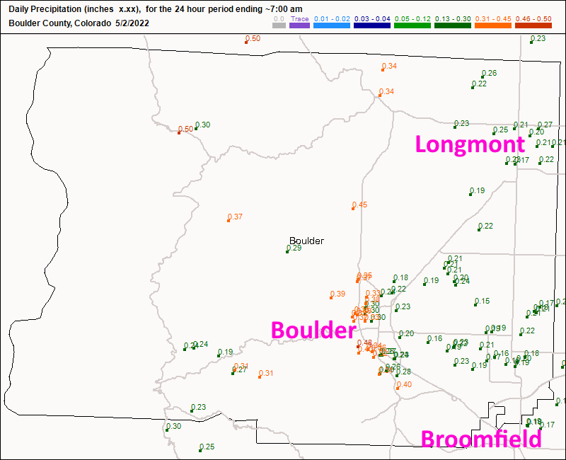
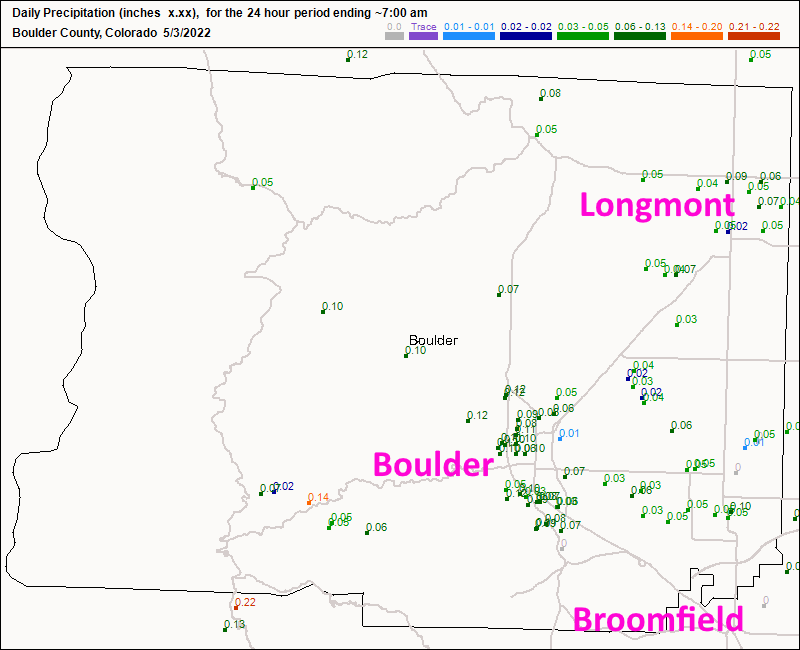
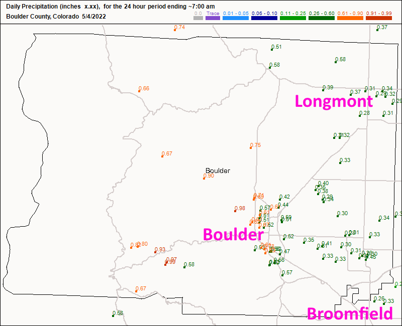
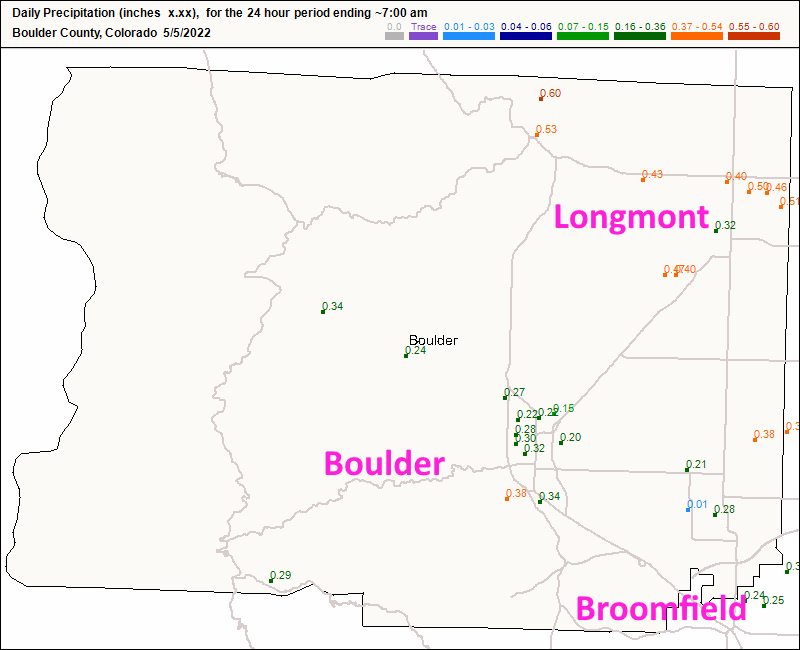
If you look at the four update maps below (Figure 1u, 2u, 3u, and 4u). Most locations pulled in more than an inch of water.  Hurray!

We return to highs hovering around 80F for most of the next week.  There is a small cool down and equally small chance of showers Sunday. Enjoy this weekend!


Figure1u_05052022
Figure 1 update: the rainfall total as of 7am Monday from CoCoRaHS.
Figure2u_05052022
Figure 2 update: the rainfall total as of 7am Tuesday from CoCoRaHS.
Figure3u_05052022
Figure 3 update: the rainfall total as of 7am Wednesday from CoCoRaHS.
Figure4u_05052022
Figure 4 update: the rainfall total as of 7am Thursday from CoCoRaHS.

End Thursday Update.

Forecast Discussion:

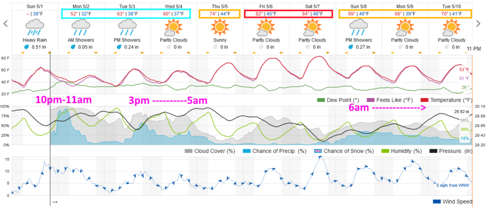
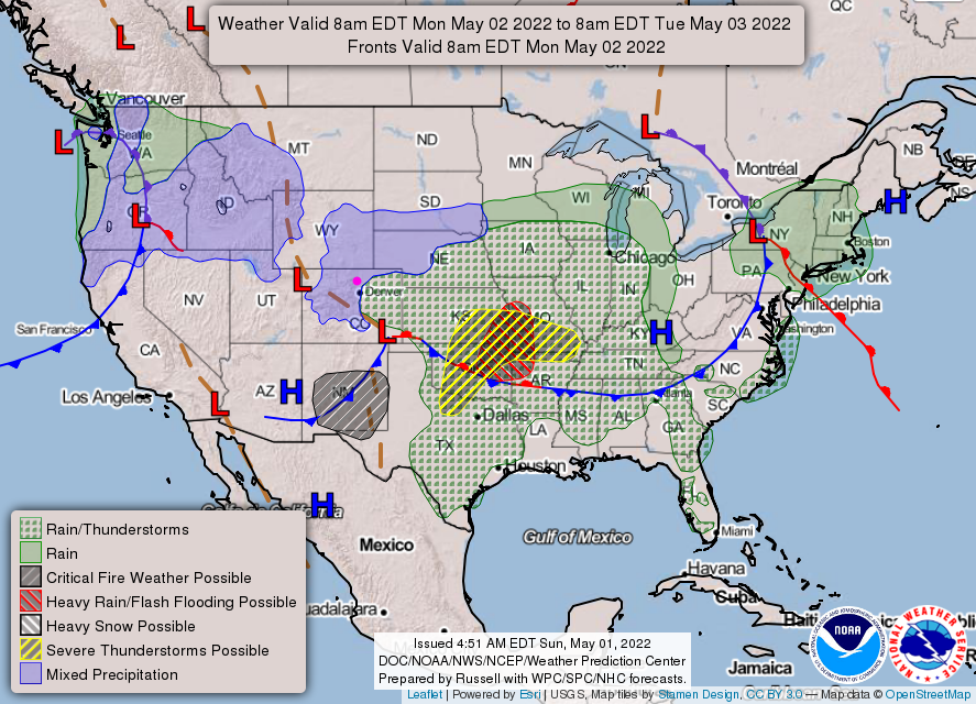
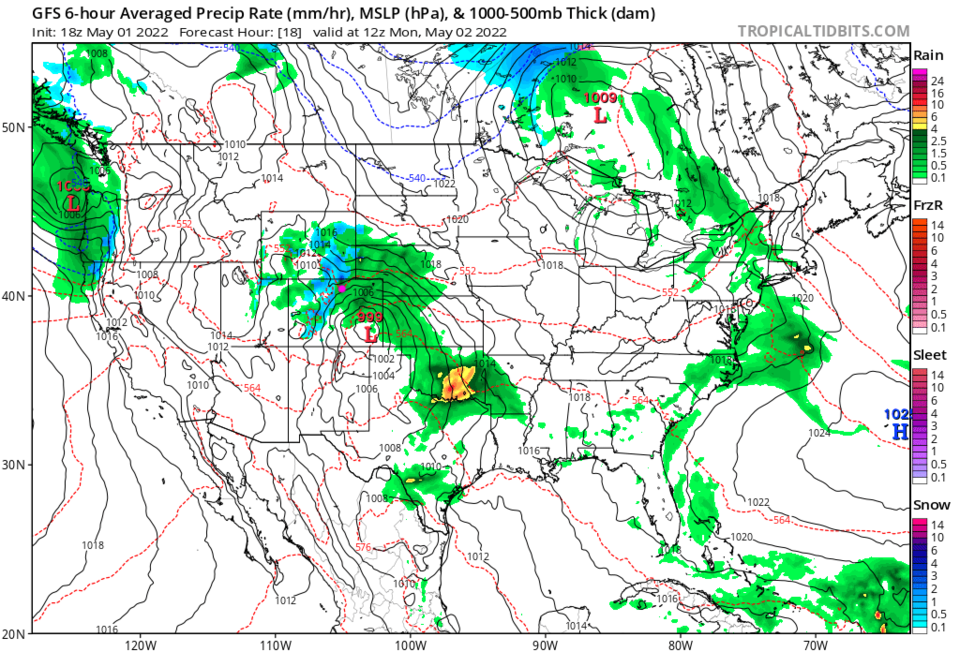
A cool front has passed over the state Sunday afternoon, rain showers are beginning as I write. The best chance of showers and some thunder will be from 10 p.m. Sunday to 11 a.m. Monday (Figure 1).  There are indications that many locations along I-25 may get 1/3rd to 1/2 inch of water (hurray!). By Monday morning, there is a low in SE Colorado pumping Gulf moisture up into the northern and eastern parts of the state (Figure 2). The 6-hour snapshot of Monday morning from the GFS gives parts of Colorado very good rainfall coverage (Figure 3).

Another system moves in bringing a return of rain showers (snow levels will remain high, above 9-10,000 feet) Tuesday afternoon through early Thursday morning (Figure 1).

Figure1_05012022
Figure 1: The 10 day graphical forecast for Denver from weatherunderground.com
Figure2_05012022
Figure 2: The 8am surface weather analysis from the NWS and NOAA.
Figure3_05012022
Figure 3: the 6 hour precipitation average around Monday sunrise from tropicaltidbits.com and the GFS

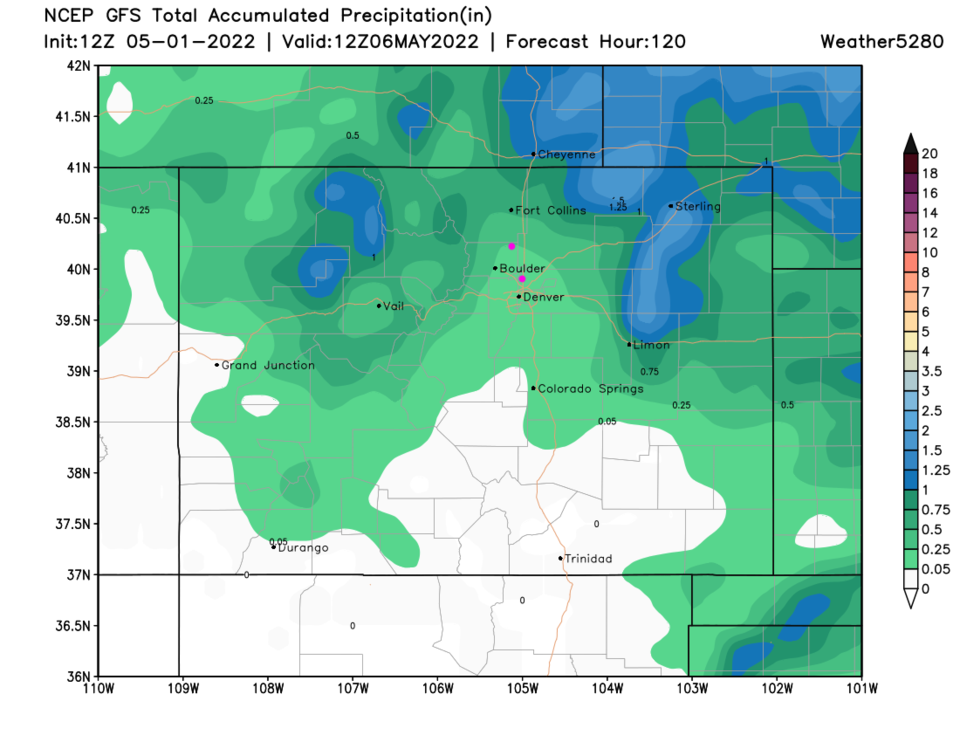
The Longer Range Forecast:

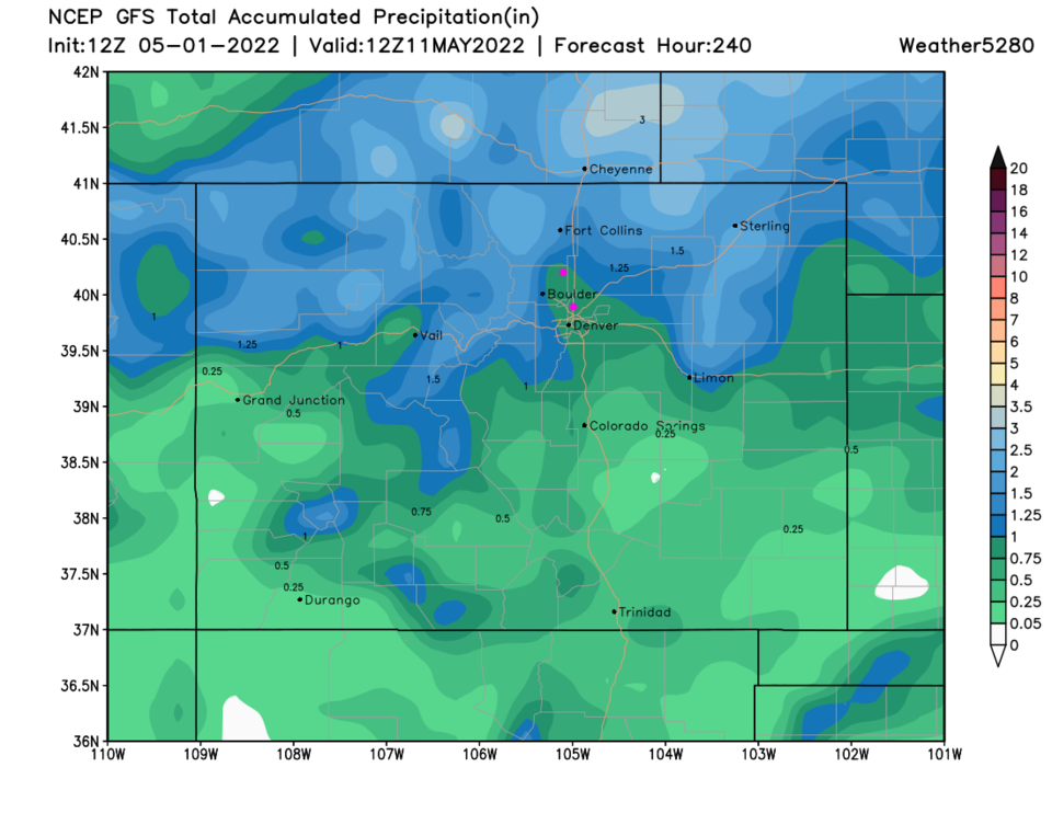
Our 5-day precipitation forecast from the GFS gives Broomfield 0.10 to 0.20 inch of water. Longmont may see closer to 0.25-0.4 (Figure 4). Scooping the next storm and another chance of showers next weekend in the 10-day forecast (Figure 5) from the GFS gives Broomfield to Longmont about 0.8 inch of water. (That is less than the last forecast had, and more believable.)

Figure4_05012022
Figure 4: the 5 day precipitation total from the GFS and weather5280.com
Figure5_05012022
Figure 5: the 10 day precipitation total from the GFS and weather5280.com


About the Author: John Ensworth

John Ensworth used to work from Longmont as the PI for the NASA through the IGES (The Institute for Global Environmental Strategies). He now teaches technology, algebra, astronomy, meteorology, film school, and Lego robotics to middle/high school.
Read more


Comments


Current Weather

Mostly cloudy

Mostly cloudy

56°F

UV Index
1 Low
Pressure
29.68 Steady
Visibility
8 miles
Dewpoint
44 °F
Humidity
64%
Wind
WNW 1.1 mph
Gust
2.7 mph
Wind Chill
56 °F

Hourly Forecast

Today
8 AM
53°F
Mostly sunny
Today
9 AM
59°F
Mostly sunny
Today
10 AM
65°F
Mostly sunny
Today
11 AM
71°F
Partly sunny
Today
12 PM
78°F
Partly sunny
Today
1 PM
85°F
Partly sunny
Today
2 PM
86°F
Partly sunny
Today
3 PM
87°F
Mostly sunny
Today
4 PM
88°F
Mostly sunny
Today
5 PM
87°F
Mostly sunny
Today
6 PM
85°F
Mostly sunny
Today
7 PM
82°F
Mostly sunny

7 Day Forecast

Partly sunny

Tuesday

88 °F

Partly sunny and very warm with the temperature approaching the record of 92 set in 1962; breezy this afternoon


Clear

Tuesday Night

50 °F

Breezy this evening; otherwise, clear


Partly sunny w/ showers

Wednesday

73 °F

Cooler with sunshine giving way to clouds, becoming windy with a shower in the area in the afternoon; elevated fire risk due to gusty winds and low humidity


Cloudy

Wednesday Night

47 °F

Overcast


Intermittent clouds

Thursday

69 °F

Breezy and pleasant with intervals of clouds and sunshine


Mostly cloudy

Thursday Night

43 °F

Cloudy most of the time


Intermittent clouds

Friday

71 °F

Beautiful with times of clouds and sun


Intermittent clouds

Friday Night

43 °F

Partly cloudy


Mostly cloudy

Saturday

74 °F

Mostly cloudy


Cloudy

Saturday Night

49 °F

Cloudy with a thundershower late


Sunrise and Sunset

Sunrise
5:47 AM
Sunset
8:07 PM

Based on AccuWeather data