Skip to content
Join our Newsletter

Mon Update:The Front Range Forecast: Heat with afternoon storms

In Brief:

A ridge brings heat and summer pattern moisture.

Monday update

We are finally in the 'routine' of summer.  The National Weather Service has used the 'M' word in the discussions - monsoon.  There is subtropical moisture coming into the state giving most of the state a chance of afternoon thunderstorms even while a big ridge in the west keeps temperatures somewhat above normal. Stay cool and hydrated!

figure1u_07242023
Figure 2 update: the 10 day graphical forecast for Denver from weatherunderground.com

End Monday update.

Wednesday update:

Here we go again! Northwest flow brought in a cool front today. The cool front brought in moisture. Ripples in the upper air flow will be able to kick off severe storms, again, over the region.

Wednesday- Marginal risk (1 out of 5) just east of I-25 for winds and damaging hail.

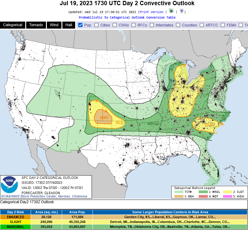
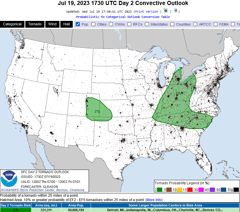
Thursday (Figure 1 update) - Marginal risk up into the mountains (hail and high winds) and a Slight risk (2 out of 5) from Longmont south and east (hail, high winds, isolated tornadoes (Figure 2 update.)

Friday - Marginal risk along I-25 and east-west about 50 miles (hail and high winds). These chances may increase as we move into the mornings-of those days. Stay alert!

figure1u_07192023
Figure 1 update: the severe thunderstorm outlook for Thursday from the SPC in Norman, OK.
figure2u_07192023
Figure 2 update: the tornado outlook for Thursday from the SPC in Norman, OK.

End Wednesday update.

The Forecast Discussion:

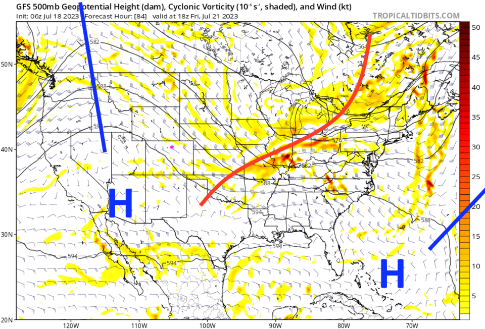
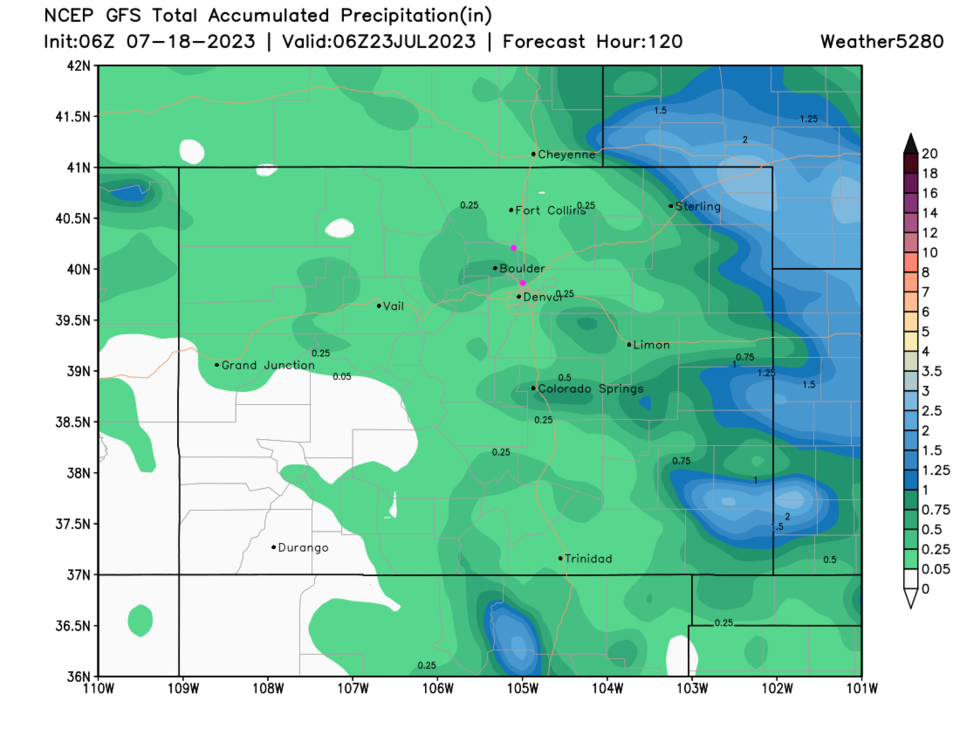
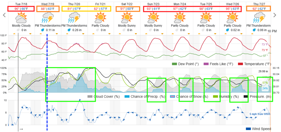
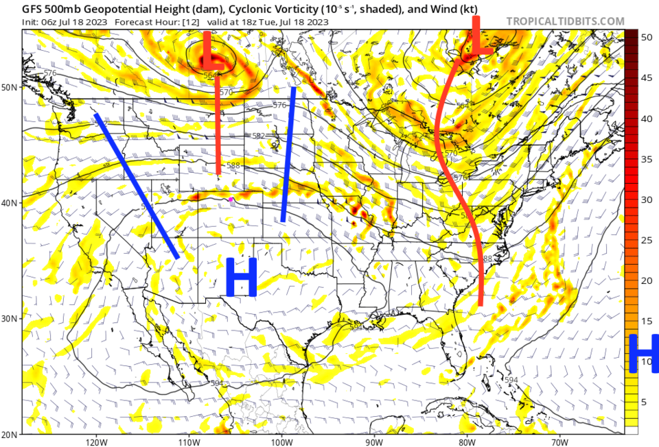
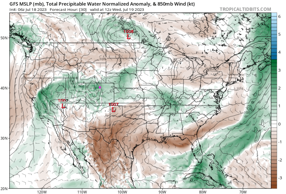
We have one more hot day on Tuesday (Figure 1) with the powerful high pressure system sitting to our south (Figure 2). It begins to back off to the west Tuesday evening allowing a cool front to arrive Wednesday morning (dotted blue line, Figure 1).  Rain chances jump up right away as the front brings in more moisture (green shading Figure 3) and we cool to below normal temperatures for a couple of days.

figure1_07182023
Figure 1: the 10 day graphical forecast for Denver from weatherunderground.com
figure2_07182023
Figure 2: the 500mb upper air forecast map for Tuesday noon from the GFS and tropicaltidbits.com
figure3_07182023
Figure 3: the precipitatable water forecast map for Wednesday morning from the GFS and tropicaltidbits.com

The Longer Range Forecast:

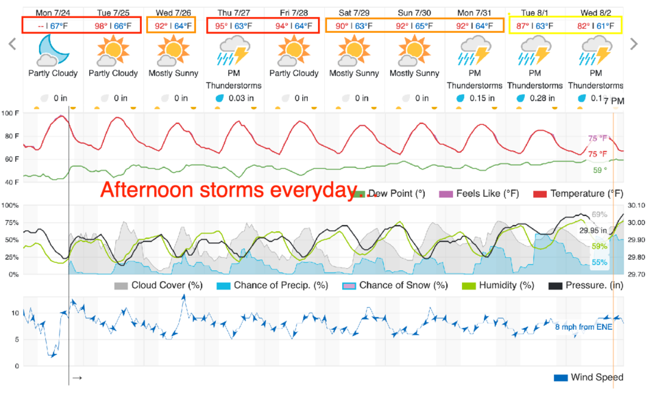
By the weekend, the ridge moves more to the west putting us into a northwest flow pattern. We dry out and warm up to normal, then above normal temperatures again next week. Notice that our "U.S. monsoon" like pattern begins to set up with afternoon storm chances and above normal temperatures (Figure 4) next week.

Rainfall over the next 5 days is light and confined, mainly, to the eastern Plains.  The southwest corner of the state is still being skipped. They need rainfall to return!

figure4_07182023
Figure 4: the 500mb upper air forecast map for Friday noon from the GFS and tropicaltidbits.com
figure5_07182023
Figure 5: the 5 day precipitation forecast from the GFS and weather5280.com


About the Author: John Ensworth

John Ensworth used to work from Longmont as the PI for the NASA through the IGES (The Institute for Global Environmental Strategies). He now teaches technology, algebra, astronomy, meteorology, film school, and Lego robotics to middle/high school.
Read more


Comments


Current Weather

Clear

Clear

45°F

UV Index
0 Low
Pressure
30.31 Steady
Visibility
8 miles
Dewpoint
40 °F
Humidity
84%
Wind
WNW 1.1 mph
Gust
5 mph
Wind Chill
45 °F

Hourly Forecast

Today
4 AM
45°F
Mostly clear
Today
5 AM
44°F
Mostly clear
Today
6 AM
44°F
Mostly sunny
Today
7 AM
47°F
Mostly sunny
Today
8 AM
53°F
Intermittent clouds
Today
9 AM
59°F
Intermittent clouds
Today
10 AM
64°F
Intermittent clouds
Today
11 AM
68°F
Intermittent clouds
Today
12 PM
71°F
Partly sunny
Today
1 PM
73°F
Partly sunny
Today
2 PM
75°F
Partly sunny
Today
3 PM
75°F
Intermittent clouds

7 Day Forecast

Mostly sunny

Thursday

71 °F

Sunny to partly cloudy, pleasant and warmer


Clear

Thursday Night

44 °F

Clear


Partly sunny w/ t-storms

Friday

76 °F

Sun and clouds with widely separated thunderstorms this afternoon


Mostly clear

Friday Night

46 °F

Clear to partly cloudy


Mostly sunny

Saturday

80 °F

Sunny to partly cloudy and warm


Mostly clear

Saturday Night

45 °F

Clear to partly cloudy


Partly sunny

Sunday

83 °F

Very warm with sunshine mixing with some clouds; windy in the afternoon


Partly cloudy

Sunday Night

50 °F

Partly cloudy


Mostly cloudy

Monday

84 °F

Mostly cloudy and very warm


Partly cloudy

Monday Night

52 °F

Partly cloudy


Sunrise and Sunset

Sunrise
5:52 AM
Sunset
8:02 PM

Based on AccuWeather data