In Brief:
A very wet day ahead, most probably. Heat and dry weather is coming.
Friday update:
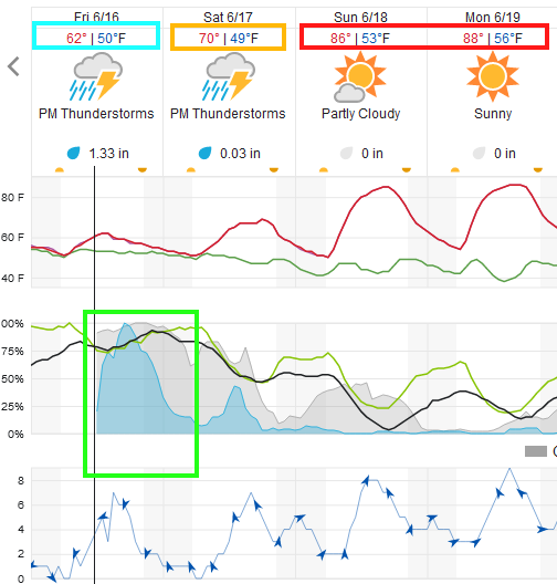
The jet stream is sliding in to add lift to the atmosphere as ample amounts of atmospheric moisture flow in behind a cool front. That spells a high chance of precipitation today and tonight (Figure 4 update). The NWS has issued the following Flash Flood Watch. Be careful out there!
Issued: 2:23 AM Jun. 16, 2023 – National Weather Service
...FLOOD WATCH IN EFFECT FROM NOON MDT TODAY UNTIL 10 PM THIS EVENING...
* WHAT...Flash flooding caused by excessive rainfall is possible.
* WHERE...The northern Front Range Foothills, Boulder and Denver metro areas, Palmer Divide, and adjacent plains through Elbert and Lincoln Counties.
* WHEN...From Noon MDT today until 10 pm this evening.
* IMPACTS...Excessive runoff may result in flooding of rivers, creeks, streams, and other low-lying and flood-prone locations. Extensive street flooding is also possible.
* ADDITIONAL DETAILS...
- Numerous showers and thunderstorms will develop this afternoon and continue into this evening. The stronger storms will be capable of producing 1 to 2 inches of rain in an hour or less, and there may be repeated rounds of heavy rainfall. While the highest threat will be over the Palmer Divide and in the Cameron Peak burn area, flash flooding will also be possible in urban locations including the Denver metro area.
PRECAUTIONARY/PREPAREDNESS ACTIONS...
You should monitor later forecasts and be prepared to take action should Flash Flood Warnings be issued.

End Friday update.
Wednesday update:
We get a bit of a break today with low storm chances (but not zero - figure 3 update). Another trough pulls in moisture and increases instability Thursday through Saturday. Severe chances may return to the Front Range and I-25 region (though the SPC is NOT including these regions yet).
THEN we get a short taste of actual summer weather before afternoon storms make a comeback mid-week.
End Wednesday update.
Monday update:
Today is going to very similar to yesterday (Sunday). Ample moisture is around as the west coast trough approaches and passes us. Storm motions will slow today increasing flooding chances. The chance of a tornado shifts a bit further south. Hail and high winds are still a risk (Marginal 1 out of 5) again.
The NWS has issued the following Flash Flood Watch
...FLOOD WATCH REMAINS IN EFFECT THROUGH THIS EVENING...
* WHAT...Flooding caused by excessive rainfall continues to be
possible.
* WHEN...Through this evening.
* IMPACTS...Excessive runoff may result in flooding of rivers,
creeks, streams, and other low-lying and flood-prone locations.
* ADDITIONAL DETAILS...
- Thunderstorms are expected to develop late this morning
through this evening across northeastern Colorado. Any
thunderstorms that develop this afternoon could produce heavy
rainfall rates.
PRECAUTIONARY/PREPAREDNESS ACTIONS...
You should monitor later forecasts and be alert for possible Flood
Warnings. Those living in areas prone to flooding should be prepared
to take action should flooding develop.
Turn around, don't drown when encountering flooded roads. Most flood
deaths occur in vehicles.
Be aware of your surroundings and do not drive on flooded roads.
Move away from recently burned areas. Life-threatening flooding of
creeks, roads and normally dry gulches is possible. Heavy rains may
trigger rockslides, mudslides and debris flows in steep terrain.
End Monday update.
Sunday update:
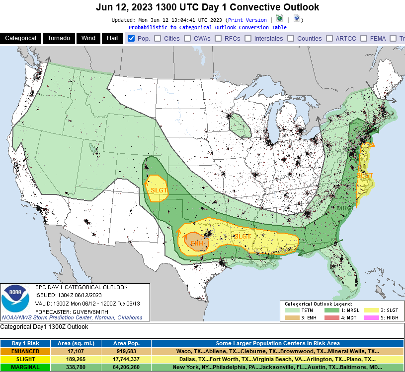
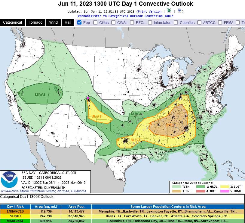
Just a quick update as the Storm Prediction Center has included I-25 communities up to Berthoud in a Marginal Risk for severe weather (1 on a scale of 1-5). They have issued a Slight Risk up to about Thorton and southward. Damaging hail and high winds are the primary risk except Denver and southward where an isolated tornado or two is possible. Keep an eye on your apps and notifications - it is possible these risk areas will expand as the SPC reassesses new data midday. Most locations should see 1/2 to 1 inch of water as activity picks up this afternoon.
End Sunday update.
The Forecast Discussion:
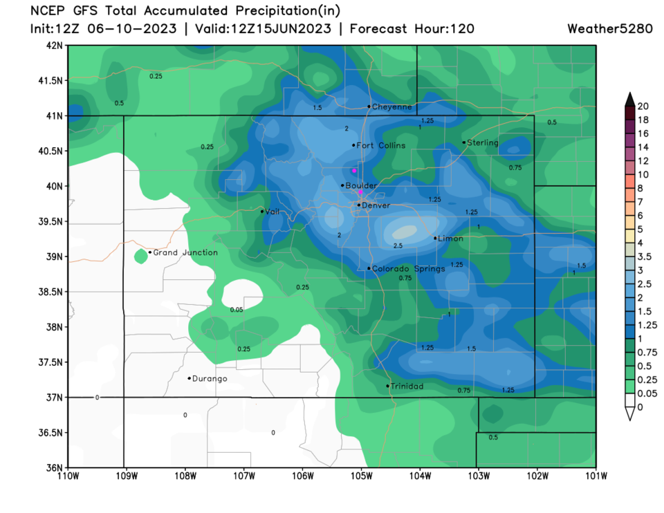
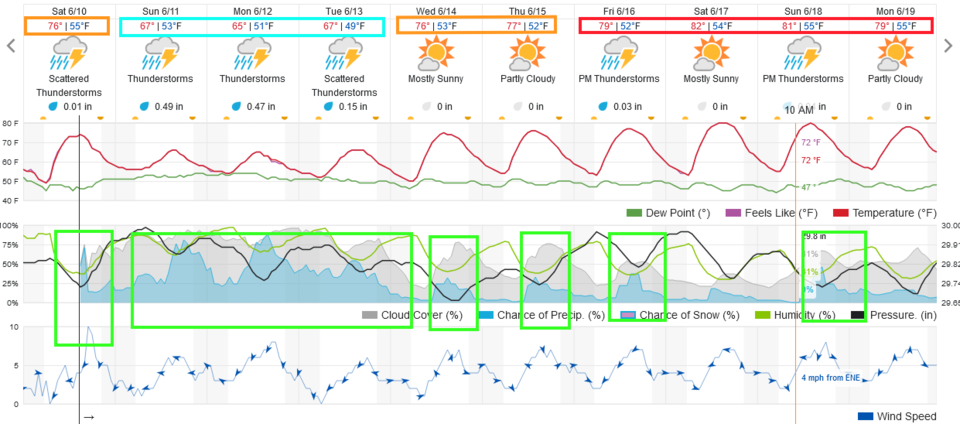
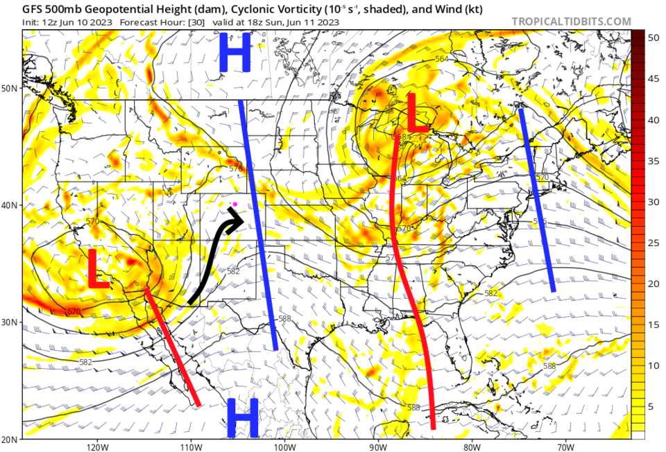
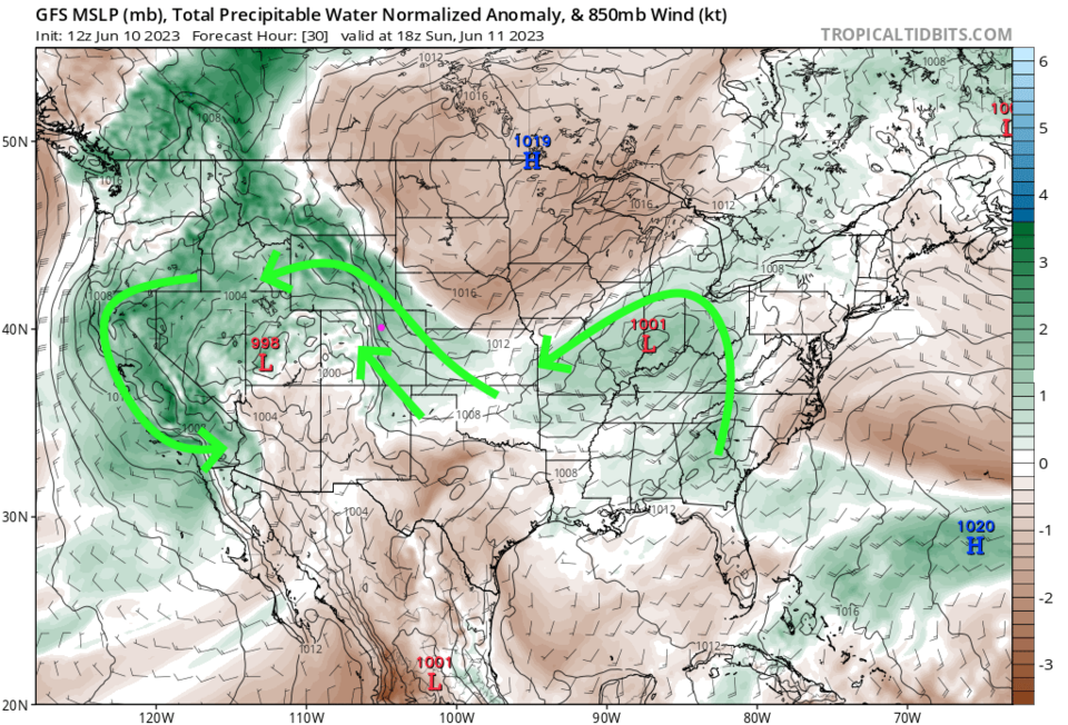
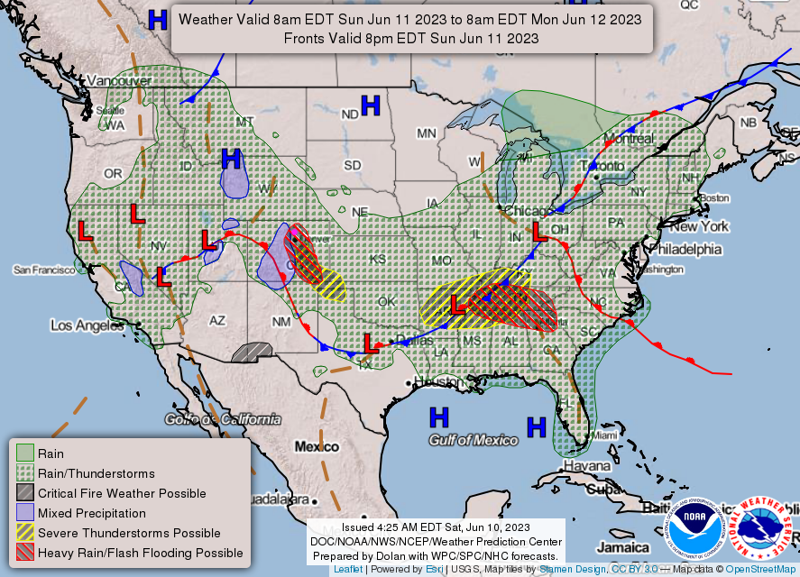
A glance at Figure 1 shows that rain chances remain elevated through Tuesday. The big ridge to our east (a high in Canada and a High in Mexico) isn't moving much. The trough (red L in figure 2) to our west will pump air from the southwest overhead (black arrow) and send short waves our way to enhance storm strength. Meanwhile, lower in the atmosphere, there is Gulf moisture heading up slope towards us (Figure 3). This means that flooding rains (red hatching Figure 4) are possible with even some snow in the higher elevations.
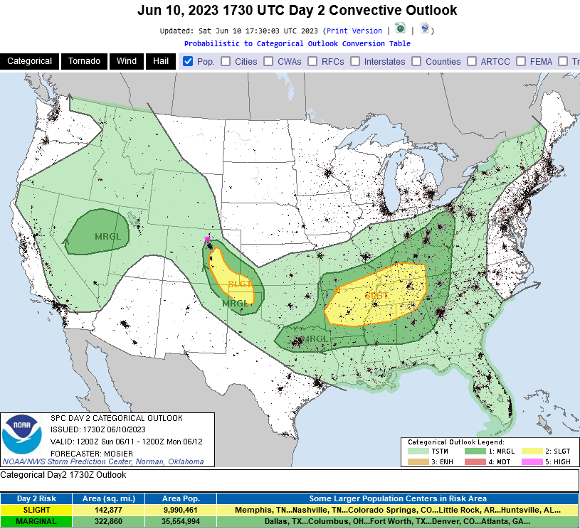
There is also a marginal risk (just up to Longmont and off to the southeast) for hail and damaging winds Sunday (Figure 5). If the skies clear in the AM, you could see conditions where weak land-spouts may form (tornado-like phenomena where warm air drains up into the sky, different than a thunderstorm creating the updraft causing a tornado to form).
The Longer Range Forecast:
Starting Wednesday, temperatures rise and storms return to an afternoon-heating-driven pattern (Figure 1). The GFS expects widespread 1-2 inches of water over the next 5 days. Wow, what a wet Spring!