Skip to content
Join our Newsletter

Sun Update: The Front Range Forecast: Good storm chances

figure3_05282023
Figure 3: the 5 day precipitation forecast from the GFS and weather5280.com

In Brief:

A healthy chance of afternoon thunderstorms and rain through the next 10 days.

Sunday Update:

My chaperone duties in Washington DC come to an end today.  A full update tomorrow!  Plenty of moisture and daytime heating plust a favorable upper air pattern means we continue with a good chance of showers for most of the week ahead.  Nothing severe on the plate.

Ens Sunday update.

Tuesday update:

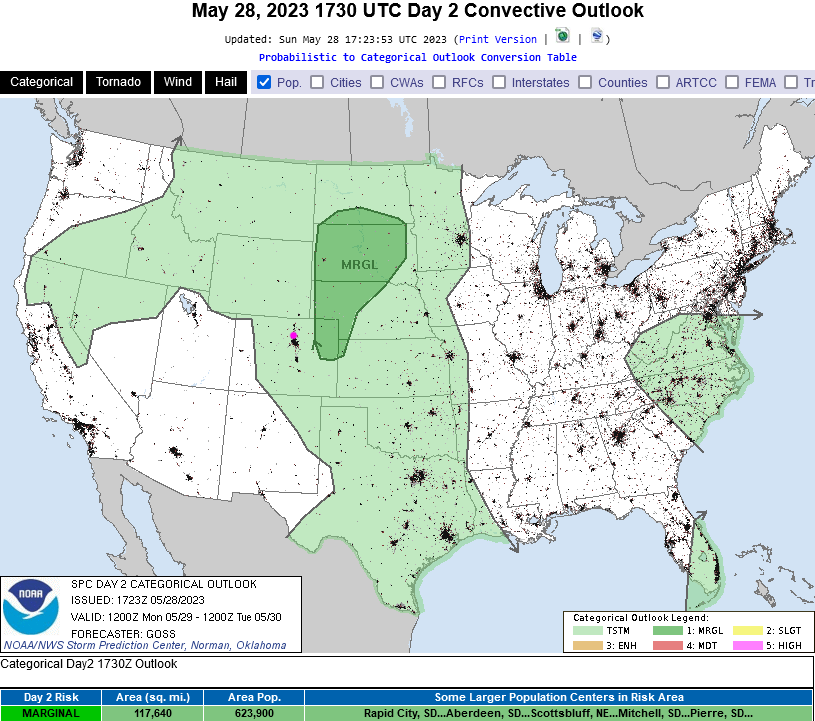
The SPC graphic is not yet out today, but we have a Marginal risk of severe weather again today (1 out of 5). The primary risk is hail and high winds again.  Keep an eye on the western sky!

End Tuesday update:

The Forecast Discussion;

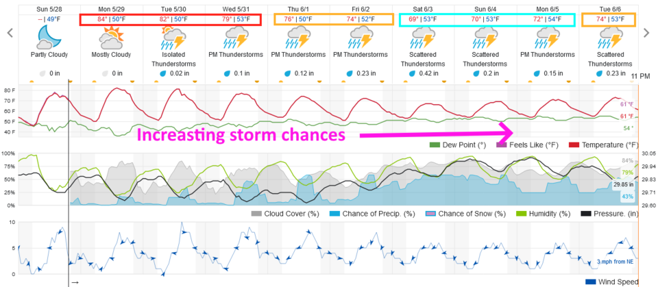
The pattern is for moisture and instability to increase a bit each day for the next 10 days (Figure 1). The severe threat moves off to the east a bit (Figure 2), but storms can produce hail and heavy rain and winds for a few minutes at any time (pulse storms - Figure 2).  We are quite warm for a few days, then cool as a trough moves in and increases rain chances a lot by Friday (Figure 1).

figure1_05282023
Figure 1: the 10 day graphical forecast for Denver from weatherunderground.com


figure2_05282023
Figure 2: the Day 2 (Monday) SPC forecast for thunderstorms and severe weather.

The Longer Range Forecast:

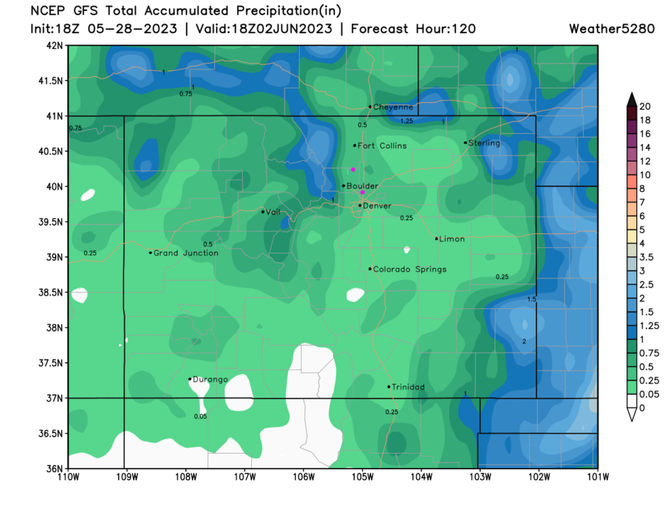
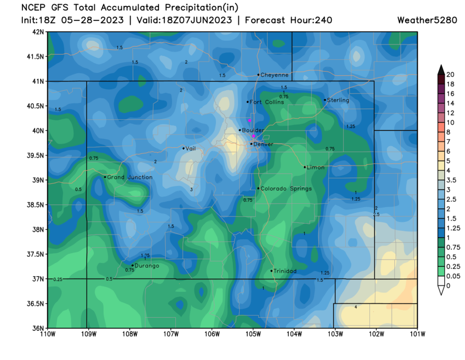
Over the next 5 days, we should see about a quater of an ince of precipitation in Longmont or Broomfield, unless a thunderstorm core hits your neighborhood (Figure 3). The increased precipitation chances later in the week may give us 1-2 inches of rain over that period (Figure 4). We are definitely in a wet pattern!

figure3_05282023
Figure 3: the 5 day precipitation forecast from the GFS and weather5280.com
figure4_05282023
Figure 4: the 10 day precipitation forecast from the GFS and weather5280.com


About the Author: John Ensworth

John Ensworth used to work from Longmont as the PI for the NASA through the IGES (The Institute for Global Environmental Strategies). He now teaches technology, algebra, astronomy, meteorology, film school, and Lego robotics to middle/high school.
Read more


Comments


Current Weather

Clear

Clear

52°F

UV Index
0 Low
Pressure
30.17 Steady
Visibility
8 miles
Dewpoint
41 °F
Humidity
66%
Wind
WNW 1.8 mph
Gust
3.5 mph
Wind Chill
52 °F

Hourly Forecast

Today
3 AM
51°F
Clear
Today
4 AM
49°F
Clear
Today
5 AM
48°F
Clear
Today
6 AM
46°F
Sunny
Today
7 AM
49°F
Sunny
Today
8 AM
56°F
Sunny
Today
9 AM
64°F
Sunny
Today
10 AM
71°F
Sunny
Today
11 AM
76°F
Mostly sunny
Today
12 PM
80°F
Mostly sunny
Today
1 PM
82°F
Mostly sunny
Today
2 PM
83°F
Intermittent clouds

7 Day Forecast

Sunny

Saturday

79 °F

Abundant sunshine; dry weather continues; have your sunglasses and/or hat handy


Clear

Saturday Night

46 °F

Clear


Partly sunny

Sunday

84 °F

Very warm with sunshine mixing with some clouds; windy this afternoon


Partly cloudy

Sunday Night

50 °F

Partly cloudy


Mostly sunny

Monday

89 °F

Mostly sunny and very warm with the temperature approaching the record of 91 set in 1962


Clear

Monday Night

54 °F

Clear and mild


Partly sunny

Tuesday

87 °F

Remaining very warm with partial sunshine; breezy in the afternoon


Clear

Tuesday Night

53 °F

Clear


Mostly cloudy

Wednesday

70 °F

Cooler with sun followed by clouds; windy in the afternoon


Mostly cloudy

Wednesday Night

47 °F

Mainly cloudy


Sunrise and Sunset

Sunrise
5:50 AM
Sunset
8:04 PM

Based on AccuWeather data