Skip to content

The Front Range Forecast: Light snow, bitter cold

In Brief:

Very cold air makes a short return and brings a little snow to I-25, a lot in the mountains.

Forecast Discussion:

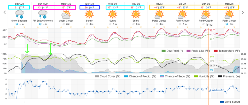
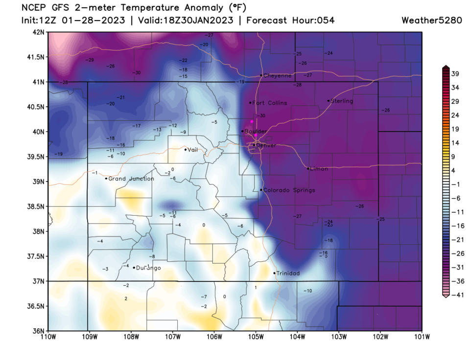
The big news is again an arctic invasion of very cold air. The front will sweep down the Plains mid-Saturday afternoon (Figure 1). Sunday and Monday will have highs hovering around 10F (maybe only single digits). The very cold air will be shallow and will not be able to climb over the Rockies to the west (Figure 4).

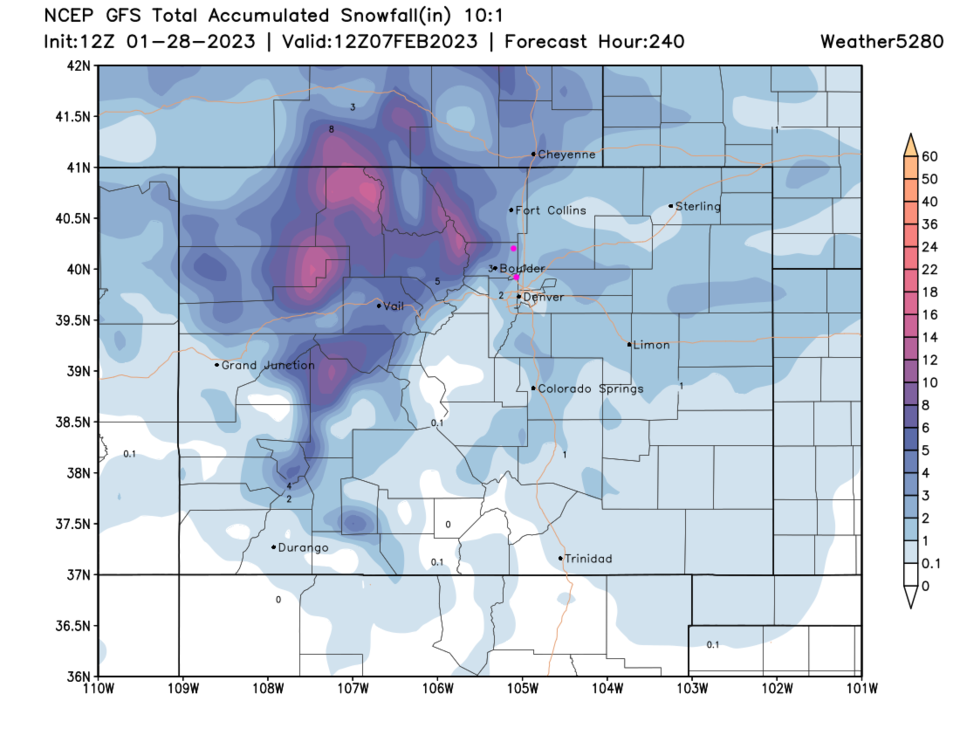
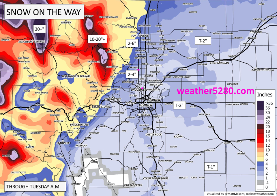
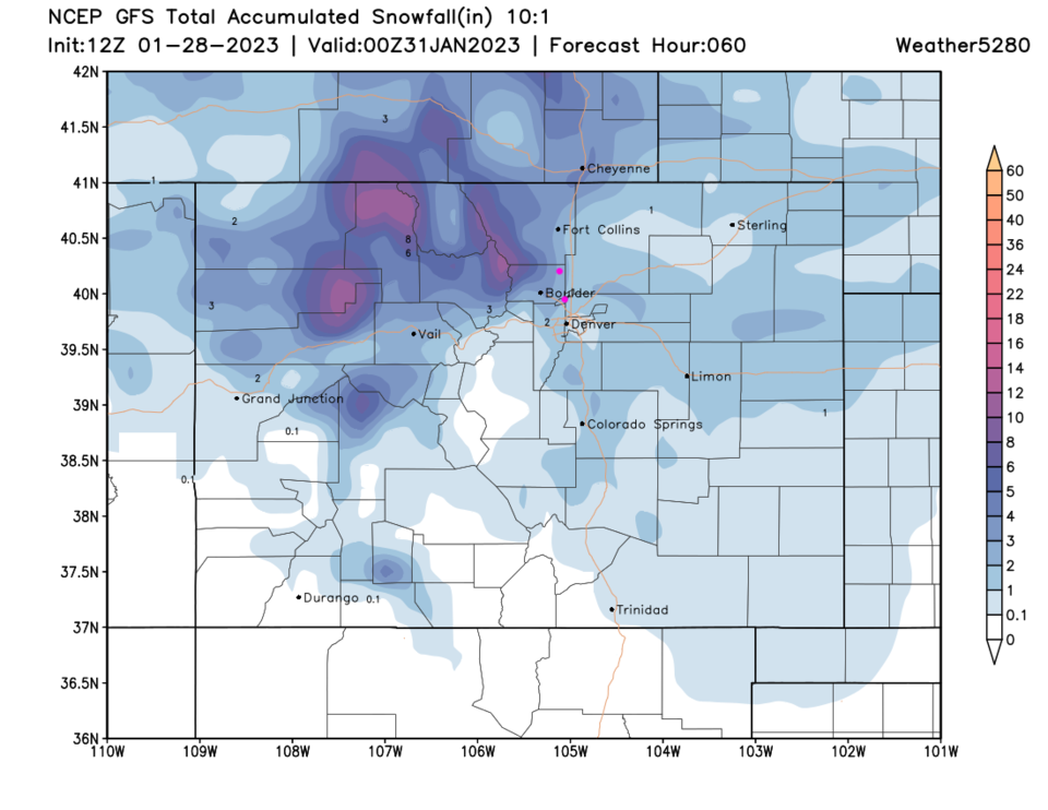
There is some snow with possible periods of freezing rain or drizzle and/or sleet Saturday evening.  Another increase in snow chances occurs Sunday evening.  Some freezing precipitation may fall, off and on, through Monday midday. Most of the state will be seeing snow and winter precipitation on Sunday (Figure 2) with heavy snow in the north and northwest mountains. This shows up well on the weather5280 forecasters map (Figure 3). He has a Trace to 2 inches along I-25 south of Loveland and 2-4 inches total just to the west of the interstate and up in Fort Collins. Snowfall is impressive to the northwest in the mountains!  This same pattern is visible in the GFS snowfall map (Figure 5). I didn't go with the 15:1 snowfall ratios since we should see more of the snow before the very cold air is in place.


figure1_01282023
Figure 1: the 10 day graphical forecast for Denver from weatherunderground.com
figure2_01282023
Figure 2: the NWS surface forecast map for Sunday.
figure3_01282023
Figure 3: the storm snowfall total forecast from the forecasters at weather5280.com
figure4_01282023
Figure 4: the surface temperature anomaly map for Monday noon from the GFS and weather5280
figure5_01282023
Figure 5: the 60 hour snowfall (10:1 ratio) forecast from the GFS and weather5280com

The Longer Range Forecast:

The cold air begins to slosh off to the east on Tuesday but we don't see 40's return until Friday (Figure 1) and no additional notable snowfall over the next 10 days except up in the mountains (Figure 6).

figure6_01282023
Figure 6: the 10 day snowfall (10:1 ratio) forecast from the GFS and weather5280com


About the Author: John Ensworth

John Ensworth works from Longmont as the Principle Investigator for the NASA Science Mission Directorate Earth and space science education product review through the IGES (The Institute for Global Environmental Strategies – www.strategies.org).
Read more


Comments

Current Weather

Mostly cloudy

Mostly cloudy

51°F

UV Index
2 Low
Pressure
29.93 Falling
Visibility
8 miles
Dewpoint
28 °F
Humidity
40%
Wind
NE 3 mph
Gust
6.7 mph
Wind Chill
51 °F

12 Hour Forecast

Today
3 PM
51°F
Cloudy
Today
4 PM
50°F
Cloudy
Today
5 PM
48°F
Cloudy
Today
6 PM
46°F
Cloudy
Today
7 PM
44°F
Cloudy
Today
8 PM
42°F
Partly cloudy
Today
9 PM
39°F
Partly cloudy
Today
10 PM
37°F
Partly cloudy
Today
11 PM
36°F
Partly cloudy
Tomorrow
12 AM
35°F
Partly cloudy
Tomorrow
1 AM
34°F
Partly cloudy
Tomorrow
2 AM
32°F
Partly cloudy

7 Day Forecast

Showers

Thursday

51 °F

Rather cloudy and warmer; a shower in places this afternoon


Partly cloudy

Thursday Night

27 °F

Partly cloudy


Mostly cloudy

Friday

51 °F

Considerable cloudiness


Rain and snow

Friday Night

27 °F

An evening rain or snow shower; breezy late with a little snow at times, up to 1"; untreated surfaces will be slippery


Partly sunny w/ flurries

Saturday

40 °F

Partly sunny, windy and colder with a few flurries


Intermittent clouds

Saturday Night

20 °F

Partly cloudy


Flurries

Sunday

41 °F

Cloudy and cold with a couple of snow showers


Intermittent clouds

Sunday Night

18 °F

Partly cloudy and cold


Intermittent clouds

Monday

37 °F

Cold with times of clouds and sun


Mostly clear

Monday Night

16 °F

Mainly clear and cold


Sunrise and Sunset

Sunrise
6:59 AM
Sunset
7:15 PM

Based on AccuWeather data