Skip to content
Join our Newsletter

The Front Range Forecast: Mild and quiet, big mountain snows

In Brief:

Quiet mild weather, some wind a times, big mountain snows.

Forecast Discussion:

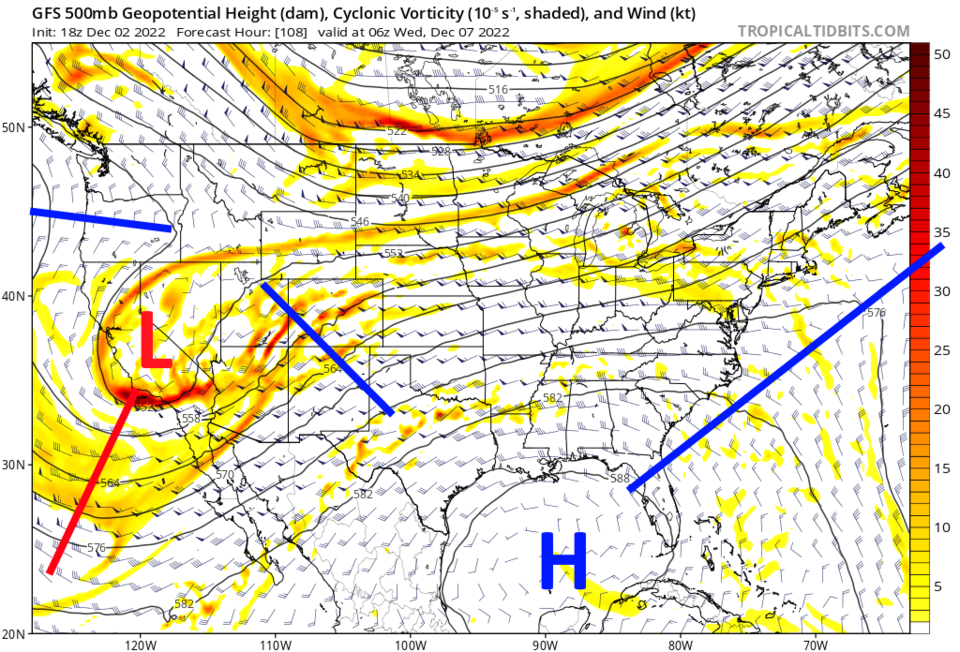
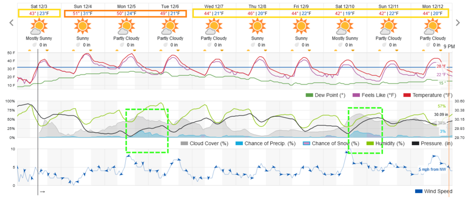
A ridge sits in the west giving us above normal temperatures much of the time this week. A cool front may give small storm chances Tuesday but things should remain quiet along I-25 (Figure 1).

figure1_12032022
Figure 1: the 10 day graphical forecast for Denver from weatherunderground.com

The Longer Range Forecast:

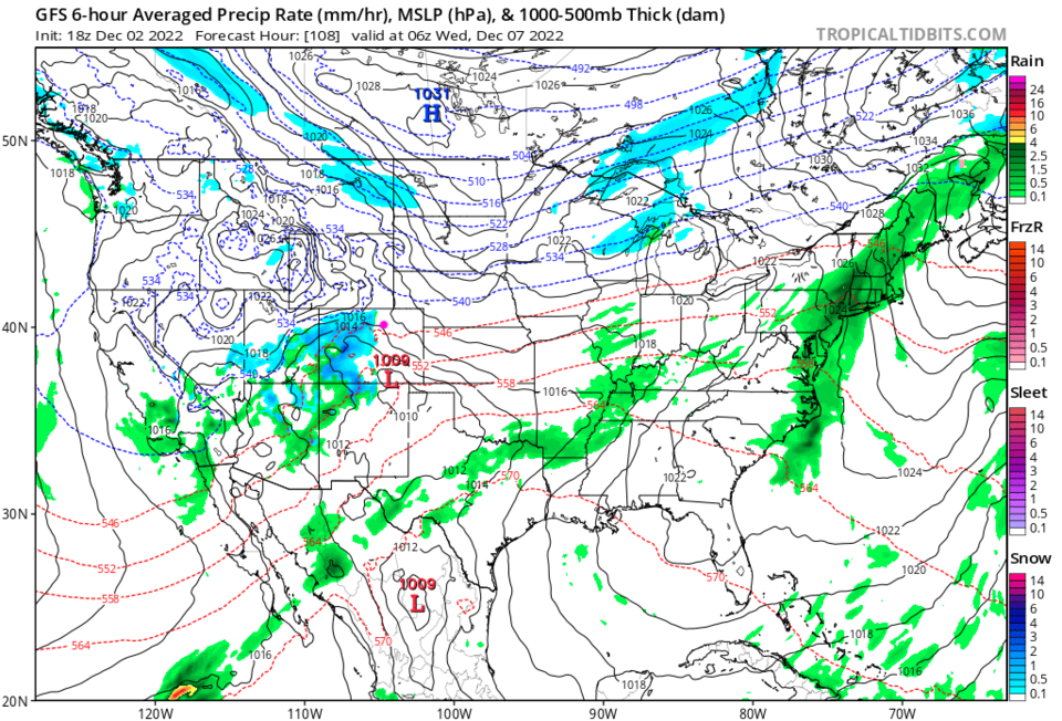
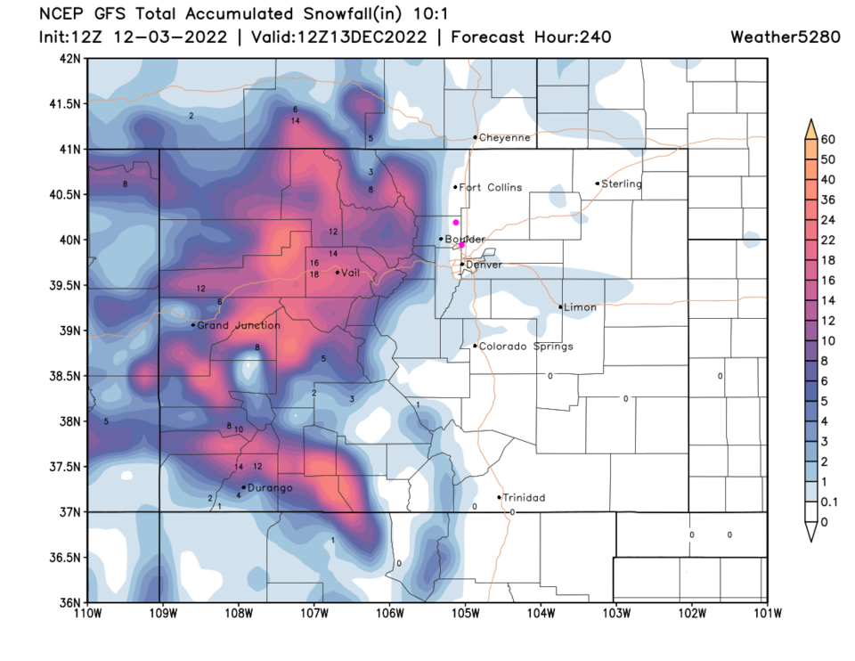
That small storm chance comes from a western trough that pulls north of the state ultimately (Figure 2). Wave after wave of snow will hit the western side of the state (Figure 3). Over the next 10 days, not much precipitation hits east of the mountains but higher elevvation locations get 1.5 to 2 feet of snow (Figure 4). Hurray for the skiers!


figure2_12032022
Figure 2: the 500mb map for early Wednesday morning from the GFS and tropicaltidbits
figure3_12032022
Figure 3: the surface forecast map for early Wednesday morning from the GFS and tropicaltidbits
figure4_12032022
Figure 4: the 10 day snowfall forecast from the GFS and weather5280.com


About the Author: John Ensworth

John Ensworth used to work from Longmont as the PI for the NASA through the IGES (The Institute for Global Environmental Strategies). He now teaches technology, algebra, astronomy, meteorology, film school, and Lego robotics to middle/high school.
Read more


Comments


Current Weather

Mostly clear

Mostly clear

69°F

UV Index
0 Low
Pressure
30.14 Rising
Visibility
8 miles
Dewpoint
59 °F
Humidity
71%
Wind
NW 1.7 mph
Gust
2.9 mph
Wind Chill
69 °F

Hourly Forecast

Tomorrow
12 AM
67°F
Mostly cloudy w/ showers
Tomorrow
1 AM
65°F
Partly cloudy
Tomorrow
2 AM
64°F
Mostly clear
Tomorrow
3 AM
62°F
Clear
Tomorrow
4 AM
61°F
Clear
Tomorrow
5 AM
60°F
Clear
Tomorrow
6 AM
58°F
Sunny
Tomorrow
7 AM
62°F
Sunny
Tomorrow
8 AM
68°F
Mostly sunny
Tomorrow
9 AM
74°F
Mostly sunny
Tomorrow
10 AM
80°F
Mostly sunny
Tomorrow
11 AM
84°F
Mostly sunny

7 Day Forecast

Intermittent clouds

Saturday

82 °F

Clouds giving way to sun; high levels of ozone will lead to poor air quality


Mostly clear

Saturday Night

58 °F

A shower in spots late this evening; otherwise, clear to partly cloudy


Partly sunny w/ showers

Sunday

94 °F

Partly sunny with a passing shower in the afternoon


Partly cloudy

Sunday Night

61 °F

Partly cloudy


Mostly cloudy w/ t-storms

Monday

94 °F

Some sun, then increasing clouds with a thundershower in spots in the afternoon


Mostly clear

Monday Night

60 °F

Clear to partly cloudy


Intermittent clouds

Tuesday

92 °F

Sun through high clouds


Partly cloudy

Tuesday Night

60 °F

Partly cloudy


Intermittent clouds

Wednesday

81 °F

Not as warm with times of clouds and sun; a thunderstorm in spots in the afternoon


Intermittent clouds

Wednesday Night

58 °F

An evening thunderstorm; otherwise, partly cloudy


Sunrise and Sunset

Sunrise
5:41 AM
Sunset
8:30 PM

Based on AccuWeather data