Skip to content
Join our Newsletter

Monday Update: The Front Range Forecast: Rain and cool weather

In Brief:

More rain showers followed by daily afternoon storms.  Welcome water!

Monday Update:

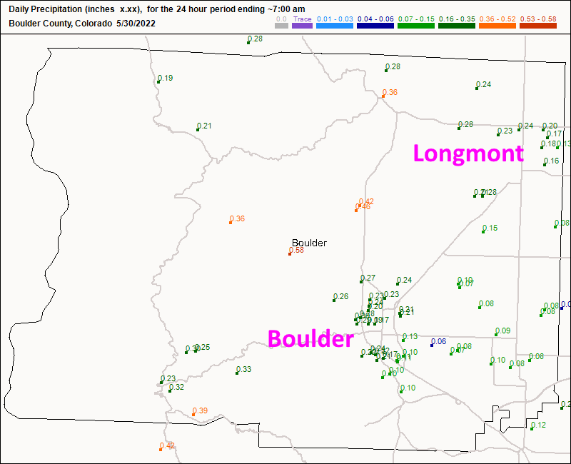
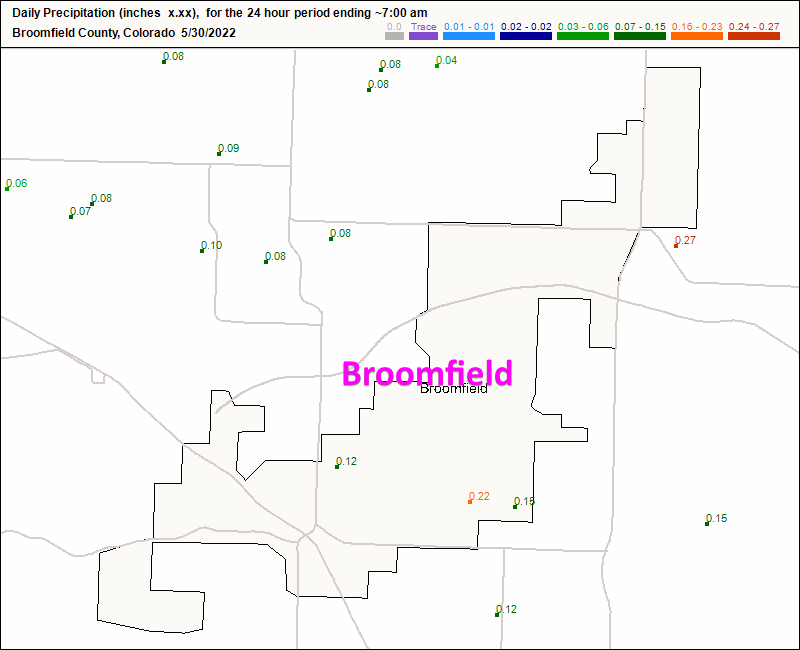
The waves of rain and thunderstorms (thankfully nothing became severe in Colorado with that storm) brought about 0.2" of water around Longmont and about a quarter to a third of an inch of rain to Boulder (Figure 2 update). Broomfield saw about 0.1 to 0.3 inch of water in spots (Figure 3 update).

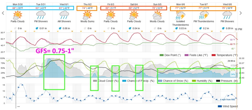
Another wet system will begin drop rain along I-25 around 3pm Tuesday continuing to mid-morning Wednesday (Figure 4 update).  The weatherunderground.com model brings about 0.6" of water with this system while the GFS leans on a heavier amount approaching an inch in many spots.

After that, we'll see some warmth return with wandering afternoon storms then an extended unsettled period next week.  We will take all the moisture we can get!

Figure2u_05302022
Figure 2 update: the CoCoRaHS rainfall reports as of 7am Monday.
Figure3u_05302022
Figure 3 update: the CoCoRaHS rainfall reports as of 7am Monday.
Figure4u_05302022
Figure 4 update: the 10 day graphical forecast for Denver from weatherunderground.com

End Monday update.

Sunday Update:

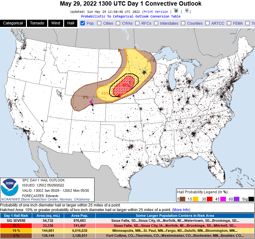
There is a Marginal Risk (1 on a scale of 1-5 where 5 is the highest threat) for severe weather associated with thunderstorms today across all of the state from an east-west line running through south Denver up to Wyoming.  There is a 5% chance that damaging thunderstorm winds (>65mph) or damaging hail (>1inch in diameter - Figure 1 update) will occur within 25 miles of any particular spot/home in this upper half of the state (as issued by the SPC and the NWS).  

Timing: Thunderstorms should start in the mountains around 10am and begin to impact the I-25 cities around 12-1pm.   Storms and showers will continue on and off into the late evening hours and even towards Monday morning. The severe threat should diminish in the early evening.  

Amounts: Most locations will receive 0.1-0.25 inch of water but some locations may approach a (fortunate) 0.5 to 1 inch of wonderful water.


Figure1u_05292022
Figure 1 update: the severe (>1inch) hail chances within 25 miles of a spot map from the SPC.

End Sunday update.

Forecast Discussion:

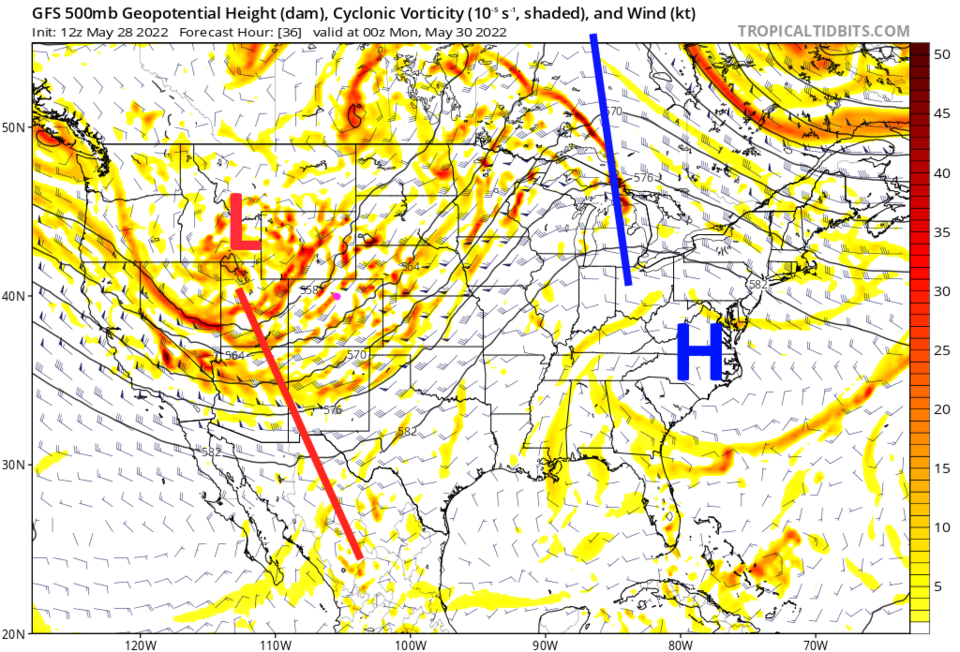
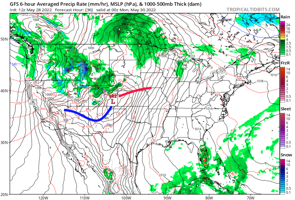
We enjoyed three days of summer-like heat at the end of the week. Our next cold front sweeps the state midday on Sunday with storms and showers ahead and behind the front (Figure 1). This is driven by a relatively slow moving trough (red line Figure 2) and a low forming downwind of the Rockies in southeastern Colorado (Figure 3).

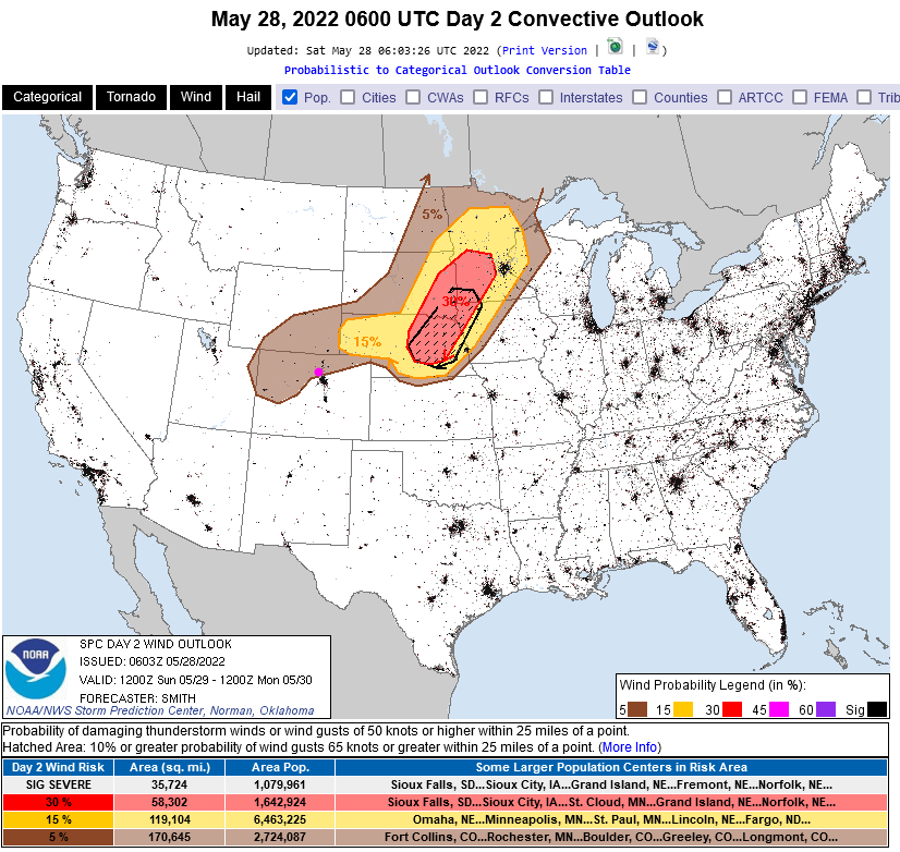
The thunderstorms that form with this system warrant a marginal risk for severe weather (1 on a scale of 1-5 where 5 is the highest risk - Figure 4).  The primary risk is for a 5% chance of wind gusts over 65mph within 25 miles of any point in the shaded area - Figure 5).

Figure1_05282022
Figure 1: the 10 day graphical forecast for Denver from weatherunderground.com
Figure2_05282022
Figure 2: the 500mb upper level map forecast for Sunday night from tropicaltidbits.com and the GFS.
Figure3_05282022
Figure 3: the surface map for Sunday night from tropicaltidbits.com and the GFS.
Figure4_05282022
Figure 4: The severe weather forecast risk map from the SPC in Norman, OK. for Sunday.
Figure5_05282022
Figure 5: The damaging winds forecast risk map from the SPC in Norman, OK. for Sunday.

The Longer Range Forecast:

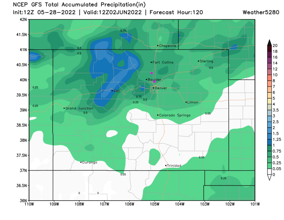
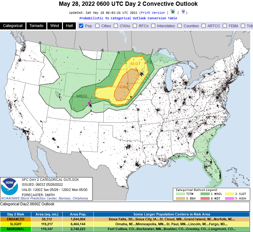
Another trough rotates through the first trough bringing in another round of showers Tuesday to Wednesday (Figure 1). Over the next 5 days, we should see about 1/2 inch of water from Longmont to Broomfield (Figure 6).  Warm weather returns on Thursday with afternoon thunderstorms giving a hint of summer 'monsoon' rainfall patterns.

Figure6_05282022
Figure 6: the 5 day precipitation totals from the GFS and weather5280.com


About the Author: John Ensworth

John Ensworth used to work from Longmont as the PI for the NASA through the IGES (The Institute for Global Environmental Strategies). He now teaches technology, algebra, astronomy, meteorology, film school, and Lego robotics to middle/high school.
Read more


Comments


Current Weather

Cloudy

Cloudy

76°F

UV Index
1 Low
Pressure
30.08 Steady
Visibility
8 miles
Dewpoint
54 °F
Humidity
46%
Wind
SSE 4.5 mph
Gust
10.5 mph
Wind Chill
76 °F

Hourly Forecast

Today
6 PM
73°F
Thunderstorms
Today
7 PM
72°F
Intermittent clouds
Today
8 PM
72°F
Partly sunny
Today
9 PM
69°F
Partly cloudy
Today
10 PM
66°F
Partly cloudy w/ t-storms
Today
11 PM
64°F
Partly cloudy
Tomorrow
12 AM
64°F
Partly cloudy
Tomorrow
1 AM
62°F
Partly cloudy
Tomorrow
2 AM
62°F
Partly cloudy
Tomorrow
3 AM
62°F
Partly cloudy
Tomorrow
4 AM
61°F
Partly cloudy
Tomorrow
5 AM
60°F
Partly cloudy

7 Day Forecast

Mostly cloudy w/ t-storms

Wednesday

78 °F

Overcast this morning, then intervals of clouds and sunshine this afternoon with a couple of thunderstorms; thunderstorms can bring hail and damaging winds


Partly cloudy w/ t-storms

Wednesday Night

59 °F

An evening thunderstorm; otherwise, partly cloudy


Thunderstorms

Thursday

89 °F

Mostly cloudy with a thunderstorm in spots in the afternoon


Partly cloudy

Thursday Night

63 °F

Partly cloudy


Mostly cloudy

Friday

91 °F

Variable cloudiness


Partly cloudy

Friday Night

61 °F

Partly cloudy


Partly sunny

Saturday

90 °F

Partly sunny with a thunderstorm in spots in the afternoon


Clear

Saturday Night

60 °F

Clear


Mostly cloudy

Sunday

93 °F

Variable cloudiness with a thunderstorm in spots in the afternoon


Clear

Sunday Night

59 °F

Clear


Sunrise and Sunset

Sunrise
5:44 AM
Sunset
8:28 PM

Based on AccuWeather data