Skip to content
Join our Newsletter

The Front Range Forecast: Real cold and some snow arrive

In Brief:

We are on the western edge of a massive cold air outbreak that is hitting the U.S. Some snow.

The Forecast Discussion:

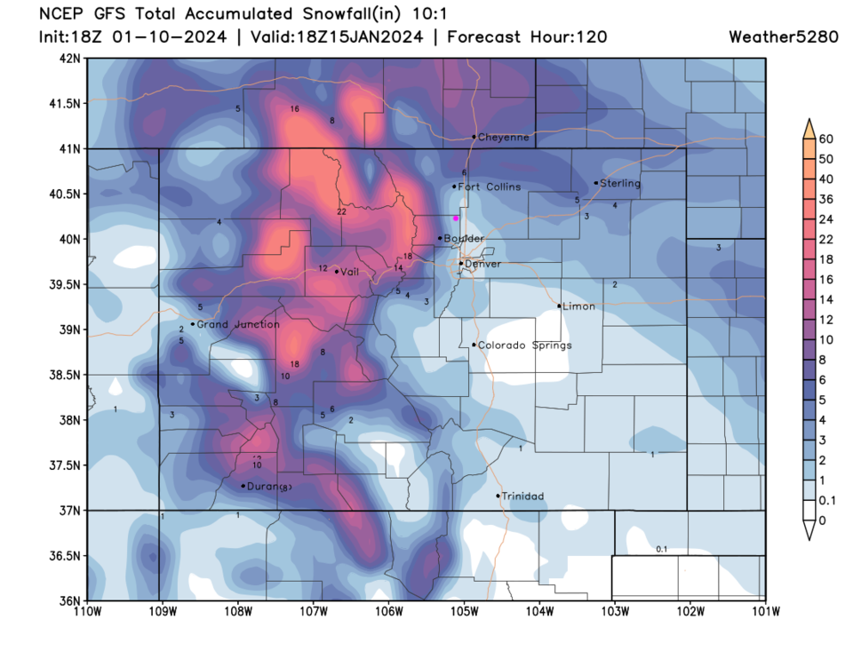
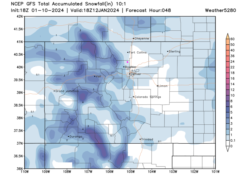
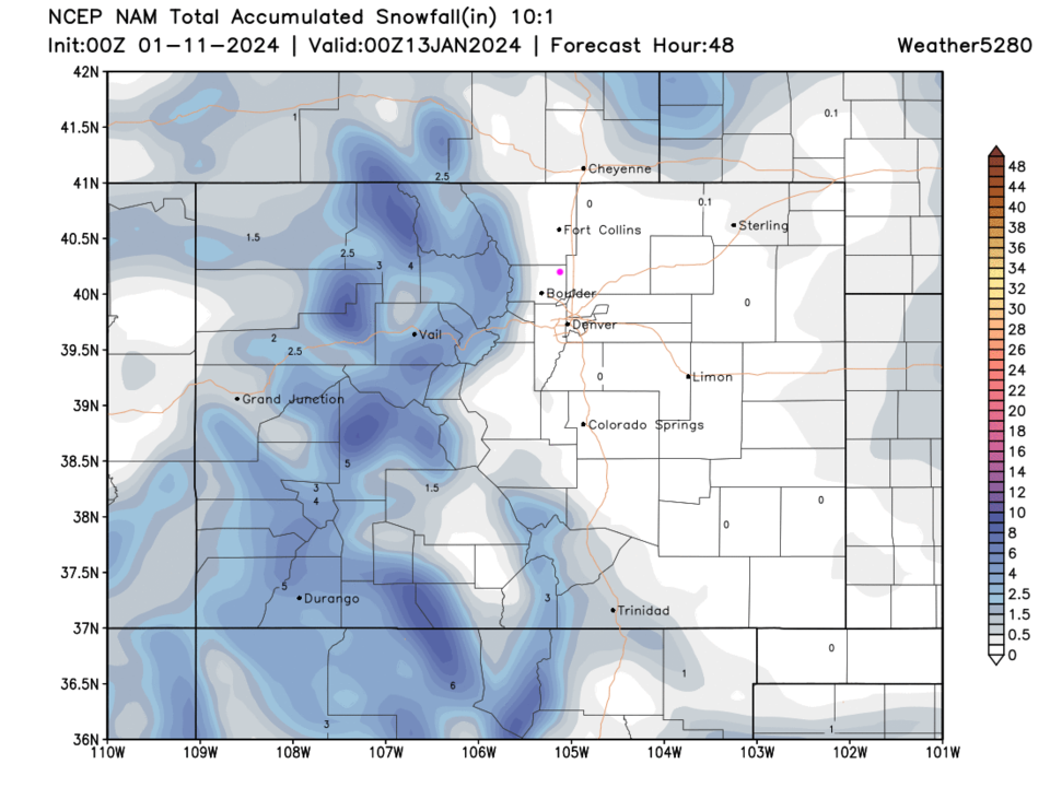
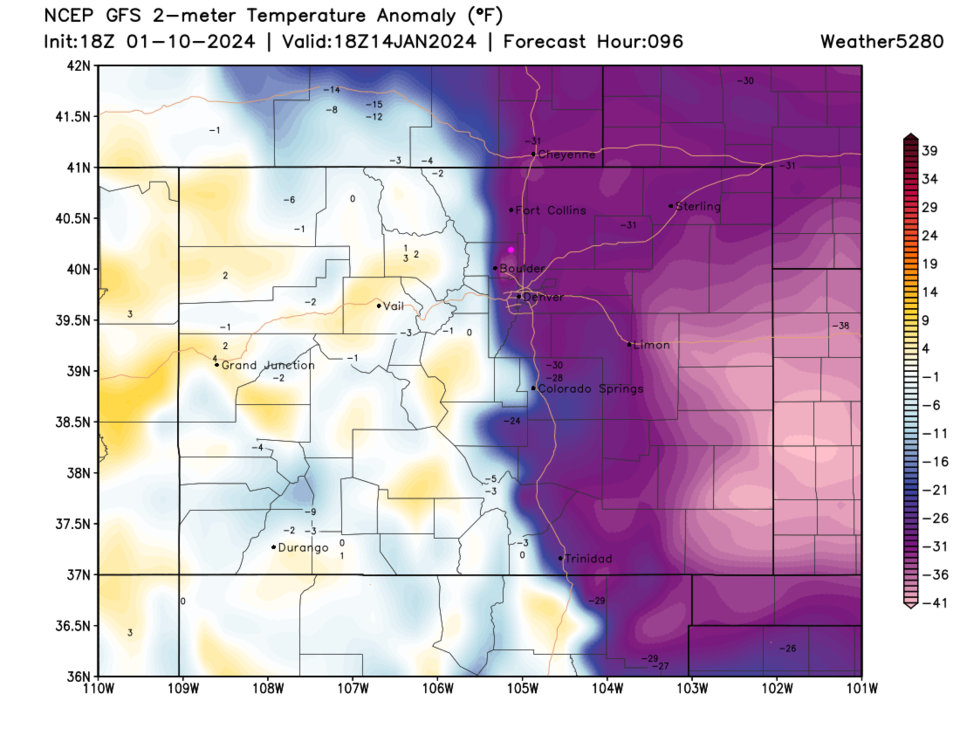
A line between Longmont and Lyons will be the western edge of very cold air that is spreading over the nation (Figure 5). The first shot of cold air hits Thursday keeping temperatures below freezing for a day and a half and light snow on the lower elevations, healthy snow up in the mountains (Figure 1, Figure 2-4).

The low lands should see an inch or less of snow while the mountains get up to 6 inches (Figure 2-4). Even though Friday sees a brief warm up, Thursday, and Saturday through Monday will be very cold.  We "might" see a high on Sunday between 0F and 8F (models don't predict extremes well- Figure 5).

This is a fairly extended period of very cold air with a shot of snow Thursday, and Sat/Sun/Mon AM's.  If I can narrow down snow amounts better, I'll post it here, but it is a different kind of storm (multiple weak pulses in very cold air).

figure1_01102024
Figure 1: the 10 day graphical forecast for Longmont from weatherundreground.com
figure2_01102024
Figure 2: the 10:1 snowfall forecast for the next 48 hours (through Thursday) from the GFS and weather5280.com
figure3_01102024
Figure 3: the 10:1 snowfall forecast for the next 48 hours (through Thursday) from the NAM and weather5280.com
figure4_01102024
Figure 4: the snowfall forecast from weather5280.com and Matt Makens through Thursday.
figure5_01102024
Figure 5: the 2 meter above ground temperature anomaly (departure from normal) for Sunday noon from the GFS and weather5280.com

The Longer Range Forecast:

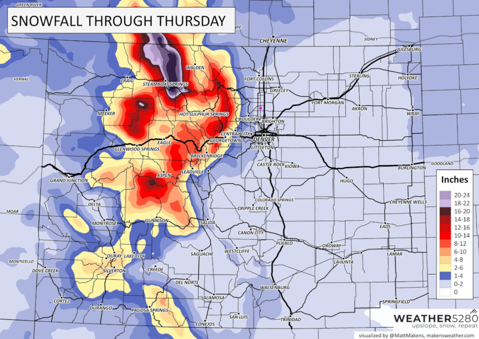
Over the next 10 days, the low lands (except north of Fort Collins) still won't see much snow, but the mountains will pick up an important 1 -2 feet (Figure 6). After that we warm up to near normal and return to mostly dry conditions (Figure 1).

figure6_01102024
Figure 6: the 10:1 snowfall forecast for the next 10 days from the GFS and weather5280.com


About the Author: John Ensworth

John Ensworth used to work from Longmont as the PI for the NASA through the IGES (The Institute for Global Environmental Strategies). He now teaches technology, algebra, astronomy, meteorology, film school, and Lego robotics to middle/high school.
Read more


Comments


Current Weather

Cloudy

Cloudy

69°F

UV Index
1 Low
Pressure
30.21 Steady
Visibility
8 miles
Dewpoint
48 °F
Humidity
46%
Wind
E 2.9 mph
Gust
6.5 mph
Wind Chill
69 °F

Hourly Forecast

Today
5 PM
70°F
Cloudy
Today
6 PM
68°F
Mostly cloudy w/ t-storms
Today
7 PM
65°F
Intermittent clouds
Today
8 PM
61°F
Intermittent clouds
Today
9 PM
60°F
Intermittent clouds
Today
10 PM
58°F
Intermittent clouds
Today
11 PM
57°F
Intermittent clouds
Tomorrow
12 AM
56°F
Mostly cloudy w/ t-storms
Tomorrow
1 AM
55°F
Intermittent clouds
Tomorrow
2 AM
54°F
Cloudy
Tomorrow
3 AM
53°F
Cloudy
Tomorrow
4 AM
53°F
Cloudy

7 Day Forecast

Partly sunny w/ t-storms

Tuesday

78 °F

Not as warm with times of clouds and sun; a thunderstorm or two this afternoon; thunderstorms can bring gusty winds, hail and localized flooding


Mostly cloudy w/ t-storms

Tuesday Night

50 °F

A thunderstorm this evening; otherwise, increasing clouds


Mostly cloudy w/ t-storms

Wednesday

73 °F

Some sun, then turning cloudy with a couple of thundershowers in the afternoon


Partly cloudy w/ t-storms

Wednesday Night

50 °F

A couple of showers and a thunderstorm in the evening; otherwise, clearing


Mostly sunny

Thursday

74 °F

Mostly sunny and pleasant


Clear

Thursday Night

45 °F

Clear


Sunny

Friday

81 °F

Plenty of sunshine


Partly cloudy

Friday Night

47 °F

Partly cloudy


Mostly sunny

Saturday

85 °F

Mostly sunny


Clear

Saturday Night

53 °F

Clear


Sunrise and Sunset

Sunrise
6:42 AM
Sunset
7:08 PM

Based on AccuWeather data