Skip to content
Join our Newsletter

Tues Update: The Front Range Forecast: Avg Temps, Few PM Storms

Figure1u_08232022
Figure 1 update: the 10 day graphical forecast for Denver from weatherunderground.com

In Brief:

Very seasonable temperatures and small chances of afternoon storms.

Tuesday Update:

Wednesday will be dry with temperatures very close to normal.  A fairly small chance of afternoon storms returns for the next week with little change in the temperatures (except briefly Friday- Figure 1 update).  Exciting cold fronts and fall/winter weather will be here in time.  Enjoy the quiet late summer weather for now.
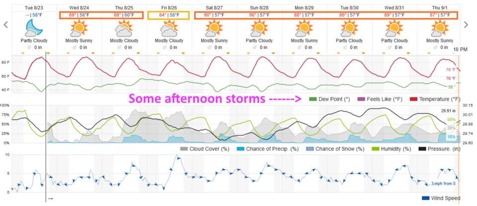
Figure1u_08232022
Figure 1 update: the 10 day graphical forecast for Denver from weatherunderground.com

End of the Tuesday Update.

The Forecast Discussion:

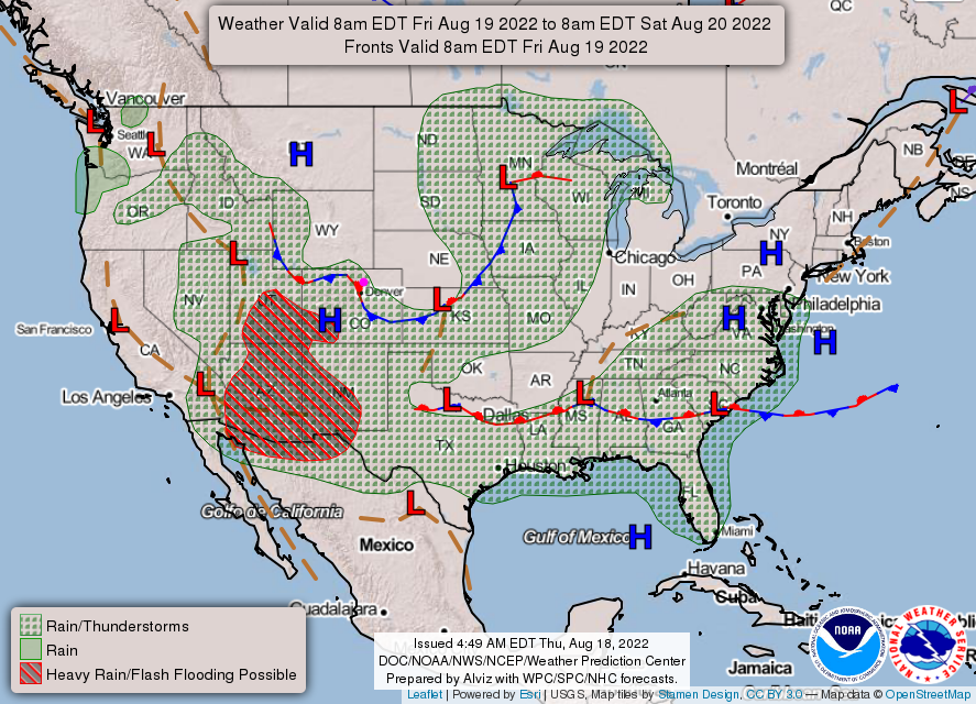
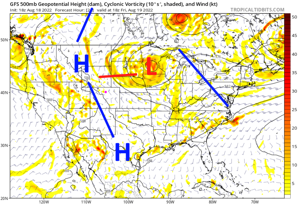
We are getting ready to say goodbye to summer.  Temperatures drop into the 80s (most of the time) and storm chances remain confined to the afternoons and even then, fairly low (Figure 1) this week. The upper air ridge (blue line Figure 2) has shunted most of the moisture to the west and is bringing dry air down from the north over eastern Colorado. This is creating a stationary front along the Front Range with low storm chances to the northeast of the front (Figure 3).

Going forward a day, the ridge remains unmoved (Figure 4). What you see is what you'll get for a while!
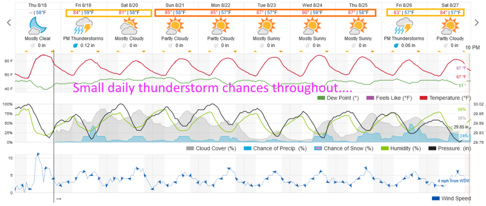
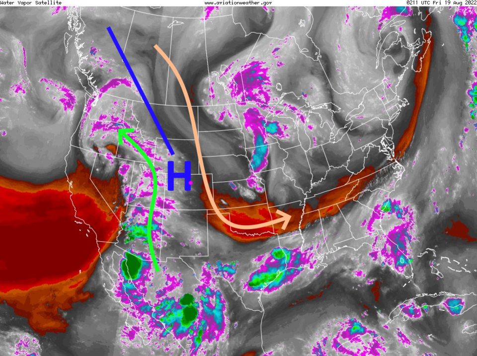
Figure1_08182022
Figure 1: the 10 day graphical forecast for Denver from weatherunderground.com
Figure2_08182022
Figure 2: the water vapor satellite loop for Thursday PM from NOAA.
Figre3_08182022
Figure 3: the NWS surface map forecast for Friday noon.
Figure4_08182022
Figure 4: the 500mb upper air map forecast for Friday noon from tropicaltidbits.com

The Longer Range Forecast:

Over the next 5 days, we may see a stray storm hit spots along I-25 north of Denver, but don't hold your breath (Figure 5).
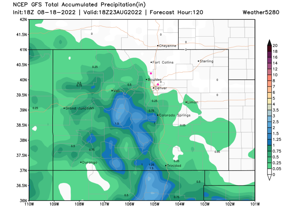
Figure5_08182022
Figure 5: the 5 day precipitation forecast from the NWS and weather5280.com


About the Author: John Ensworth

John Ensworth used to work from Longmont as the PI for the NASA through the IGES (The Institute for Global Environmental Strategies). He now teaches technology, algebra, astronomy, meteorology, film school, and Lego robotics to middle/high school.
Read more


Comments


Current Weather

Mostly cloudy

Mostly cloudy

80°F

UV Index
0 Low
Pressure
30.21 Rising
Visibility
8 miles
Dewpoint
53 °F
Humidity
39%
Wind
NNE 2.4 mph
Gust
5.9 mph
Wind Chill
80 °F

Hourly Forecast

Today
11 PM
76°F
Showers
Tomorrow
12 AM
73°F
Partly cloudy
Tomorrow
1 AM
72°F
Partly cloudy
Tomorrow
2 AM
70°F
Partly cloudy
Tomorrow
3 AM
68°F
Partly cloudy
Tomorrow
4 AM
66°F
Partly cloudy
Tomorrow
5 AM
65°F
Partly cloudy
Tomorrow
6 AM
63°F
Mostly sunny
Tomorrow
7 AM
65°F
Mostly sunny
Tomorrow
8 AM
70°F
Mostly sunny
Tomorrow
9 AM
75°F
Mostly sunny
Tomorrow
10 AM
81°F
Partly sunny

7 Day Forecast

Mostly cloudy

Sunday

93 °F

Thickening clouds


Intermittent clouds

Sunday Night

63 °F

An evening shower in places; otherwise, becoming clear


Mostly cloudy w/ t-storms

Monday

93 °F

Some sunshine giving way to clouds with a thunderstorm in the area late in the afternoon; thunderstorms can bring hail and damaging winds


Partly cloudy w/ t-storms

Monday Night

59 °F

A thunderstorm in spots in the evening; otherwise, clear to partly cloudy; thunderstorms can bring hail and damaging winds


Intermittent clouds

Tuesday

94 °F

Intervals of clouds and sunshine


Partly cloudy

Tuesday Night

60 °F

Partly cloudy


Partly sunny w/ t-storms

Wednesday

84 °F

Not as warm with times of sun and clouds; an afternoon thunderstorm; thunderstorms can bring hail and damaging winds


Mostly cloudy

Wednesday Night

58 °F

An evening thunderstorm; otherwise, mostly cloudy


Mostly cloudy

Thursday

89 °F

Mostly cloudy with a thunderstorm in spots in the afternoon


Intermittent clouds

Thursday Night

58 °F

Partly cloudy


Sunrise and Sunset

Sunrise
5:42 AM
Sunset
8:30 PM

Based on AccuWeather data