Skip to content
Join our Newsletter

The Front Range Forecast: Severe Weather nearby

In Brief:

Severe weather chances near the Front Range today, cool with rain chances in the short term.

The Forecast Discussion:

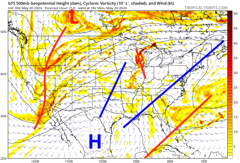
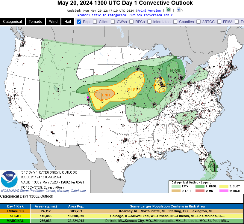
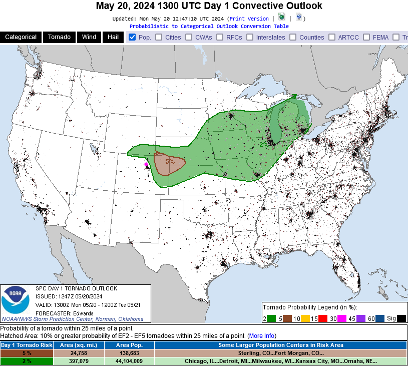
A trough (red line west of Colorado) is approaching bringing a cool front and instability (Figure 2 and 1). A fair amount of Gulf moisture has moved in from the east setting us up for a few rounds of severe weather. There is a Marginal risk of severe weather  (1 on a scale of 1 to 5) from Red Feather Lakes to Ft. Collins, to Loveland to just east of Ft. Lupton down to about DIA and eastward (Figure 3). This includes a 2% chance of a tornado within 25 miles of any given spot.

There is a Slight risk (2 on a 1-5 scale) from about Cheyenne to just east of Greeley to about Limon and east. There is a 5% chance of a tornado within 25 miles of any spot in that risk zone.  There is a 5% chance for strong damaging winds and large hail within the Marginal risk zone and a 15% chance in the Slight risk zone (within 25 miles of a location).

Stay alert to any watches and warnings form the NWS. These risk zones may get updated as the afternoon approaches. Areas to the west (which will have more garden variety thunderstorms) could be included in the risk zones if needed.

figure1_05202024
Figure 1: the 10 day graphical forecast for Longmont from weatherunderground.com
figure2_05202024
Figure 2: the 500mb upper air forecast map for Monday from the GFS and tropicaltidbits.com
figure3_05202024
Figure 3: the Day 1 severe weather forecast (today, Monday) from the SPC in Norman, OK.
figure4_05202024
Figure 3: the Day 1 tornado weather forecast (today, Monday) from the SPC in Norman, OK.

The Longer Range Forecast:

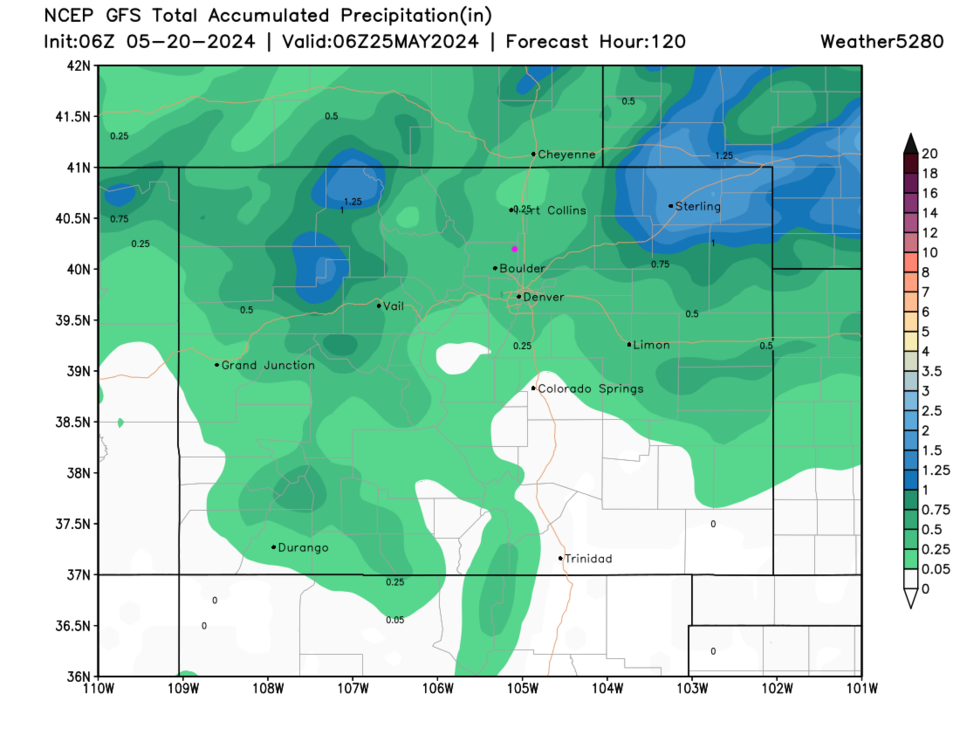
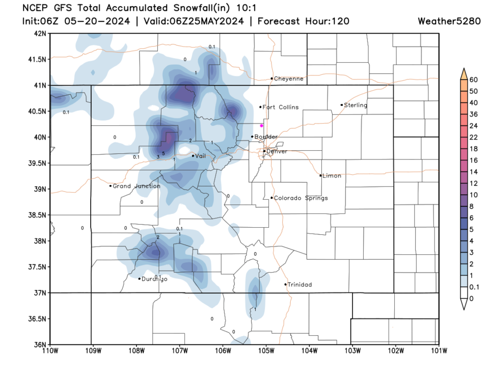
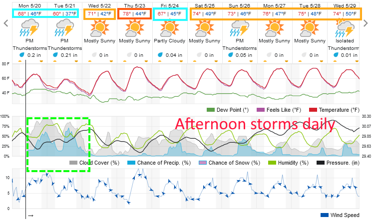
We warm up in a couple of days, then return to daily chances of afternoon thunderstorms (Figure 1). Rainfall totals over the next 5 days will be light,except for those that get a good storm (Figure 5). Snow will still fall at the higher elevations (Figure 6).

figure5_05202024
Figure 5: the 5 day precipitation forecast from the GFS and weather5280.com
figure6_05202024
Figure 6: the 5 day 10:1 snowfall forecast from the GFS and weather5280.com


About the Author: John Ensworth

John Ensworth used to work from Longmont as the PI for the NASA through the IGES (The Institute for Global Environmental Strategies). He now teaches technology, algebra, astronomy, meteorology, film school, and Lego robotics to middle/high school.
Read more


Comments


Current Weather

Clear

Clear

74°F

UV Index
0 Low
Pressure
29.66 Steady
Visibility
9 miles
Dewpoint
31 °F
Humidity
20%
Wind
S 3.9 mph
Gust
7.8 mph
Wind Chill
74 °F

Hourly Forecast

Today
2 AM
73°F
Clear
Today
3 AM
70°F
Clear
Today
4 AM
68°F
Clear
Today
5 AM
66°F
Clear
Today
6 AM
65°F
Sunny
Today
7 AM
68°F
Sunny
Today
8 AM
74°F
Sunny
Today
9 AM
80°F
Sunny
Today
10 AM
83°F
Sunny
Today
11 AM
86°F
Sunny
Today
12 PM
88°F
Sunny
Today
1 PM
90°F
Mostly sunny

7 Day Forecast

Sunny

Saturday

100 °F

Sunny and hot with the temperature approaching the record of 103 set in 2016; gusty winds, low humidity and dry brush result in a high fire threat


Clear

Saturday Night

65 °F

Clear and mild


Mostly sunny

Sunday

94 °F

Sunny to partly cloudy; breezy this afternoon; gusty winds, low humidity and dry brush result in a high fire threat


Mostly clear

Sunday Night

54 °F

Breezy this evening; otherwise, mainly clear


Mostly cloudy

Monday

78 °F

Rather cloudy and cooler


Mostly cloudy w/ t-storms

Monday Night

55 °F

A couple of evening showers and a thunderstorm; otherwise, partly to mostly cloudy


Intermittent clouds

Tuesday

80 °F

Intervals of clouds and sunshine with a thunderstorm in spots in the afternoon


Mostly cloudy

Tuesday Night

60 °F

Overcast in the evening; partly cloudy late


Partly sunny w/ t-storms

Wednesday

75 °F

Intervals of clouds and sunshine with a couple of showers and a thunderstorm


Mostly clear

Wednesday Night

54 °F

Clear to partly cloudy


Sunrise and Sunset

Sunrise
5:31 AM
Sunset
8:33 PM

Based on AccuWeather data