Skip to content
Join our Newsletter

Fri Update: The Front Range Forecast: Quiet summer weather

In Brief:

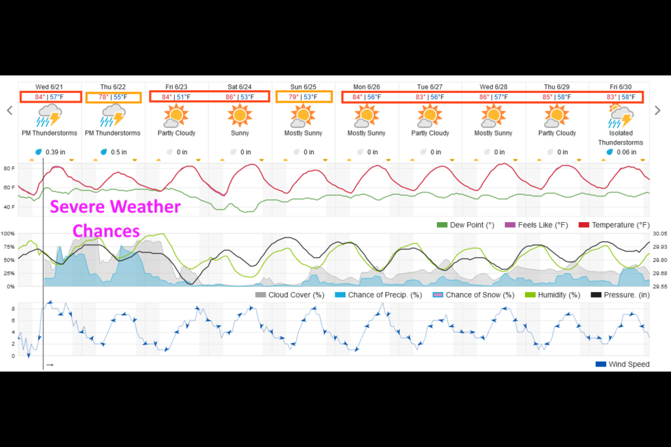
Normal summer weather sets in.

Friday Update:

We did see three tornadoes touch down yesterday, and lots of large hail. Severe weather shifts out to the eastern plains today.  You should see a wall of big thunderstorms form to the east this afternoon. We return to seasonable temperatures (mid to low 80's) with a small chance of afternoon thunderstorms each day.

End Friday update.

Thur Update:

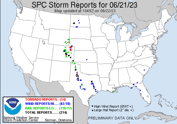
Yesterday was an active day.  Longmont received, on average, another 1/2 inch of rainfall (more on the south side). There were 8 tornadoes reported in the state (Figure 2 update). 

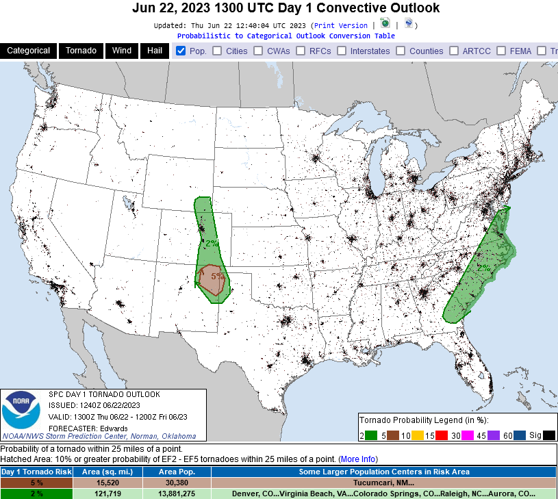
All the conditions are still in place for a repeat today BUT the risk of the more severe forms of weather, including tornadoes, includes areas west of I-25 and up into the foothills (just barely to Estes Park and including Red Feather Lakes, for example - Figure 3 update).  Like yesterday, stay alert this afternoon and evening.

figure2u_06222023
Figure 2 update:the storm report from the SPC and NWS from Wednesday.
figure3u_06222023
Figure 3 update: the tornado probability map for Thursday from the SPC and NWS.

End Thur update.

Same day update:

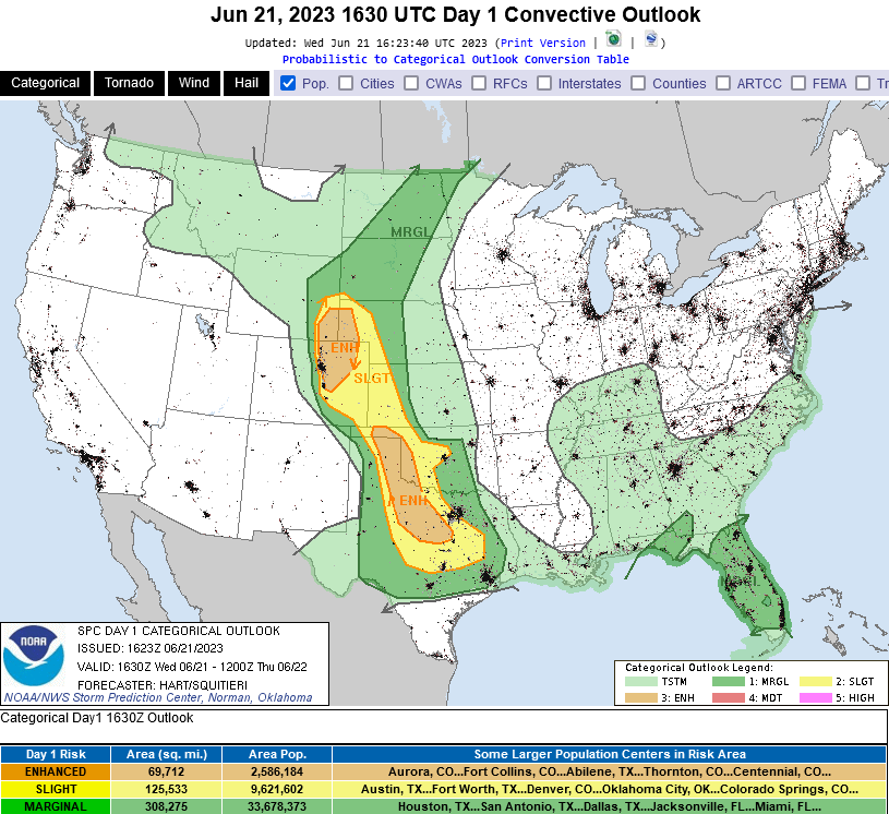
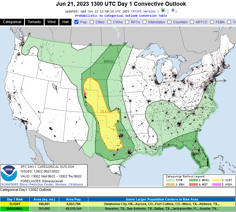
Right after today's post went up, the Storm Prediction Center upped our risk for severe weather to Enhanced (3 on a scale of 1-5). There is a better chance of large damaging hail and tornadoes from west of I-25 to out on the eastern Plains (Figure 1 update). Be alert for severe thunderstorm and tornado watches and warnings that will be issued this afternoon.  I don't post watches and warnings here (I'm not always online).  Please use apps like weatherbug and storm shield to be alerted!


figure1u_06212023
Figure 1 update: updated SPC severe weather forecast map for Wednesday.

End same Forecast Discussion.

Substantial moisture has returned, and the jet stream is setting up to help all flavors of severe weather to occur near or along I-25 today and probably Thursday as well (Figure 1). Storms should begin to effect the foothills and I-25 communities between 1-2 p.m. both days. Precipitation chances remain elevated until around 10 p.m. - 12 a.m.

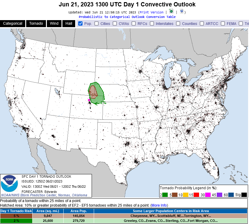
The foothills are covered by a marginal risk (1 on a scale of 1-5) while I-25 folks eastward have a slight chance (2 out of 5 - Figure 2). Hail, high winds, and even a few tornadoes are possible very close to Longmont and Broomfield and northward (Figure 3). Stay alert!

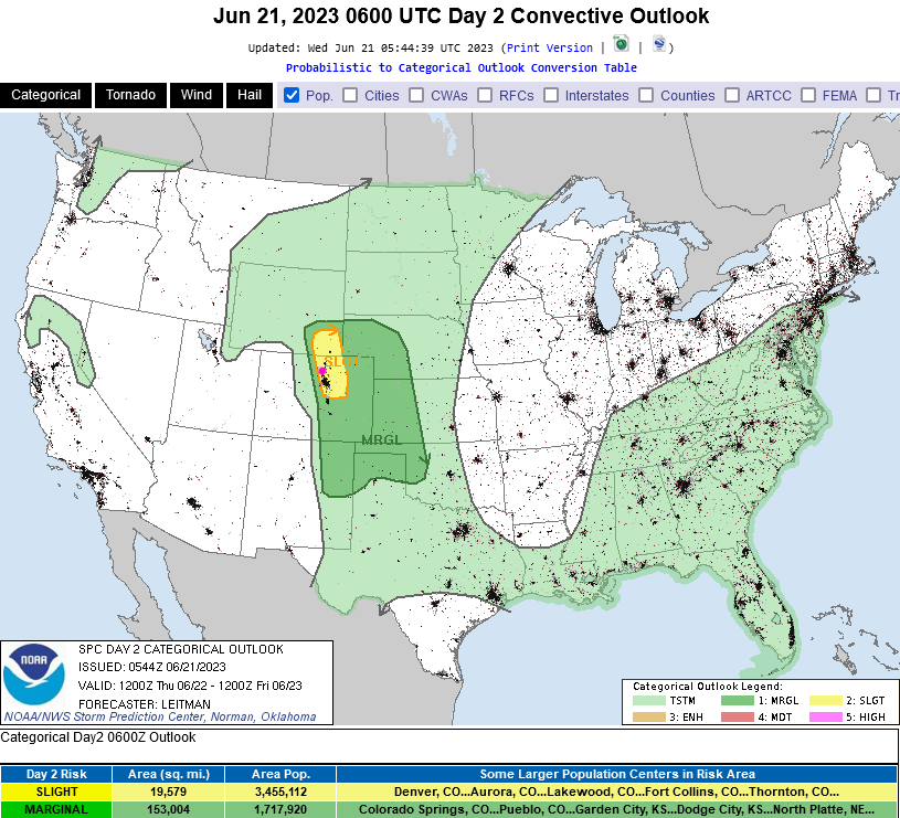
For Thursday, the slight risk pushes a bit further west.  Hail and high winds are forecasted (Figure 4). Right now (Wednesday), there is no forecast for tornado chances, but that may get updated later tonight or tomorrow morning.

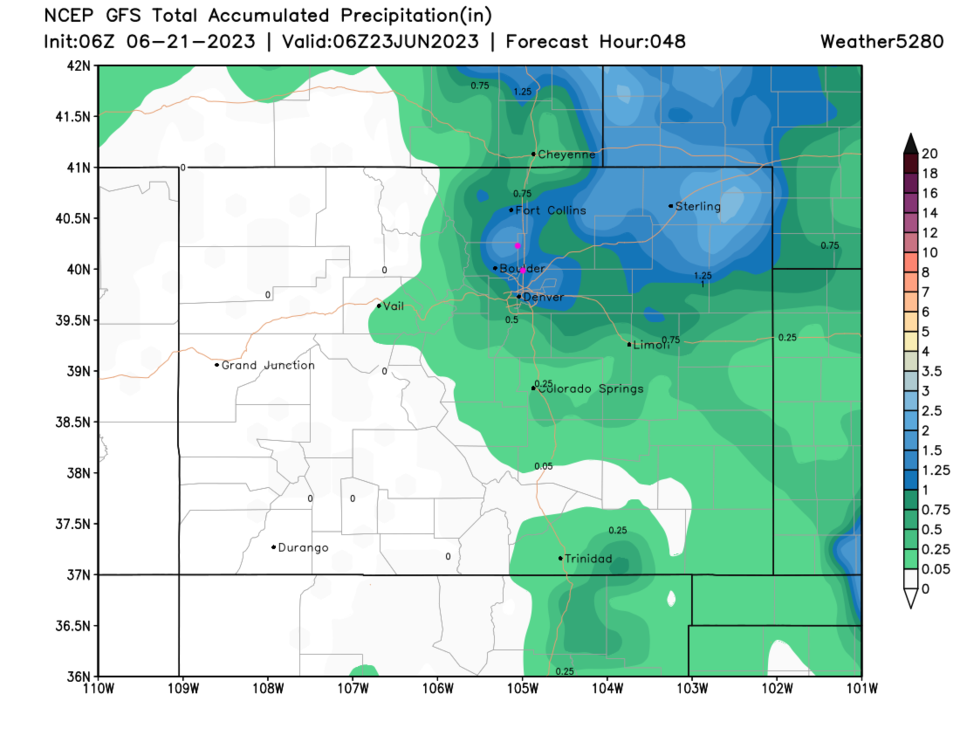
Rain, east of the Divide, may be very substantial in spots as well. Figure 5 shows widespread 1"+ totals raising flooding concerns since the region is still quite saturated from the season's excessive rain to date.

figure1_06212023
Figure 1: the 10 day graphical forecast for Denver.
figure2_06212023
Figure 2: the severe weather forecast for Wednesday from the SPC and NWS.
figure3_06212023
Figure 3: the tornado probability forecast for Wednesday from the SPC and NWS.
figure4_06212023
Figure 4: the severe weather forecast for Thursday from the SPC and NWS.
figure5_06212023
Figure 5: the 2-day precipitation forecast from the GFS and weather5280.com

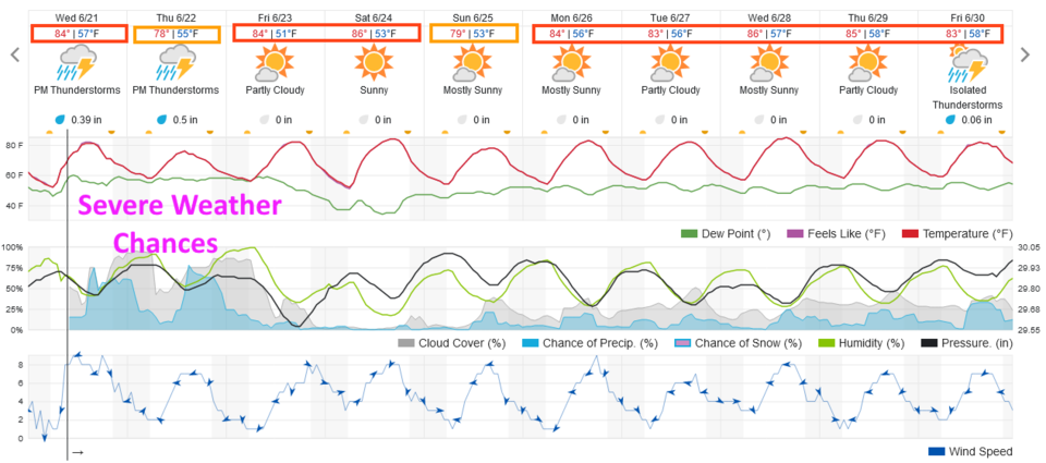
The Long Range forecast:

After these couple of days of excitement, we return to seasonable temperatures and small to zero rain chances (Figure 1). 


About the Author: John Ensworth

John Ensworth used to work from Longmont as the PI for the NASA through the IGES (The Institute for Global Environmental Strategies). He now teaches technology, algebra, astronomy, meteorology, film school, and Lego robotics to middle/high school.
Read more


Comments


Current Weather

Sunny

Sunny

80°F

UV Index
5 Moderate
Pressure
30.15 Steady
Visibility
8 miles
Dewpoint
45 °F
Humidity
29%
Wind
SE 1.9 mph
Gust
5.3 mph
Wind Chill
80 °F

Hourly Forecast

Today
12 PM
83°F
Mostly sunny
Today
1 PM
85°F
Partly sunny
Today
2 PM
87°F
Partly sunny
Today
3 PM
86°F
Mostly cloudy w/ t-storms
Today
4 PM
85°F
Intermittent clouds
Today
5 PM
84°F
Partly sunny
Today
6 PM
81°F
Partly sunny
Today
7 PM
76°F
Intermittent clouds
Today
8 PM
72°F
Mostly clear
Today
9 PM
69°F
Mostly clear
Today
10 PM
65°F
Mostly clear
Today
11 PM
61°F
Clear

7 Day Forecast

Partly sunny w/ t-storms

Monday

87 °F

Warmer with sunshine mixing with some clouds; a thunderstorm around this afternoon


Partly cloudy

Monday Night

52 °F

Partly cloudy


Partly sunny w/ t-storms

Tuesday

75 °F

Not as warm with times of clouds and sun; a thunderstorm in the area in the afternoon; thunderstorms can bring localized damaging wind gusts


Mostly cloudy w/ t-storms

Tuesday Night

52 °F

A thunderstorm in the evening; otherwise, increasing clouds


Mostly cloudy w/ t-storms

Wednesday

64 °F

Some sun, then turning cloudy with a couple of thundershowers in the afternoon


Partly cloudy w/ t-storms

Wednesday Night

47 °F

A couple of showers and a thunderstorm in the evening; otherwise, clearing


Mostly sunny

Thursday

72 °F

Mostly sunny and pleasant


Clear

Thursday Night

47 °F

Clear


Sunny

Friday

81 °F

Sunshine


Mostly clear

Friday Night

44 °F

Mainly clear


Sunrise and Sunset

Sunrise
6:41 AM
Sunset
7:09 PM

Based on AccuWeather data