Skip to content

The Front Range Forecast: Slow return of warmth, some showers

Figure4_06012022
Figure 4: the Thursday surface analysis forecast from NOAA and the NWS.

In Brief:

We warm back to the lower 80s with afternoon showers possible most days.

Forecast Discussion:

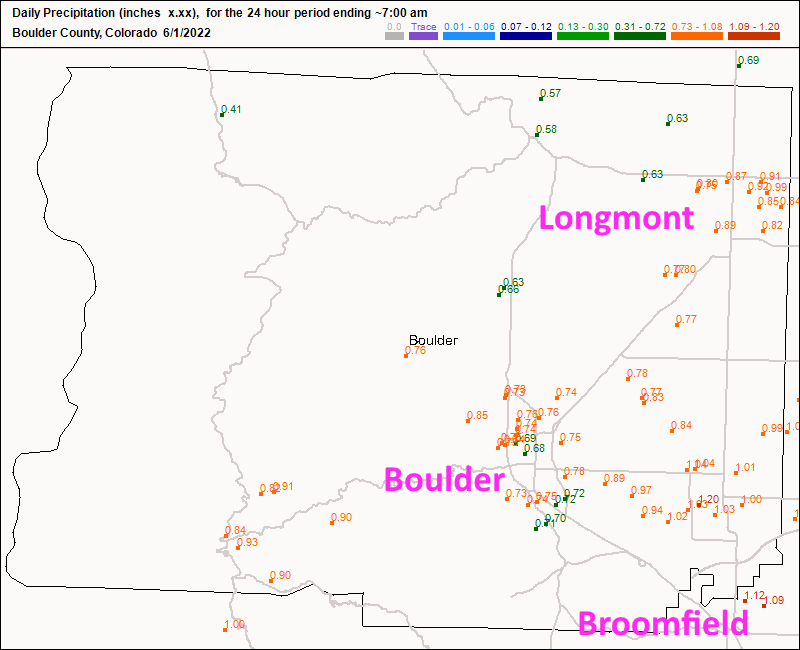
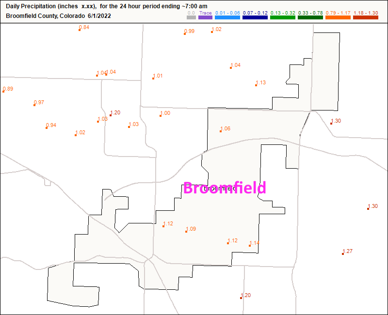
Staring with precipitation totals first ... Longmont picked up about 0.8-0.9 inch of liquid while Boulder received about the same (Figure 1). Broomfield did better with 1 to 1.3 inches of liquid (Figure 2).  Most of the Front Range saw over 0.4 inch of rain (higher elevations received a few slushy inches in the mountains).

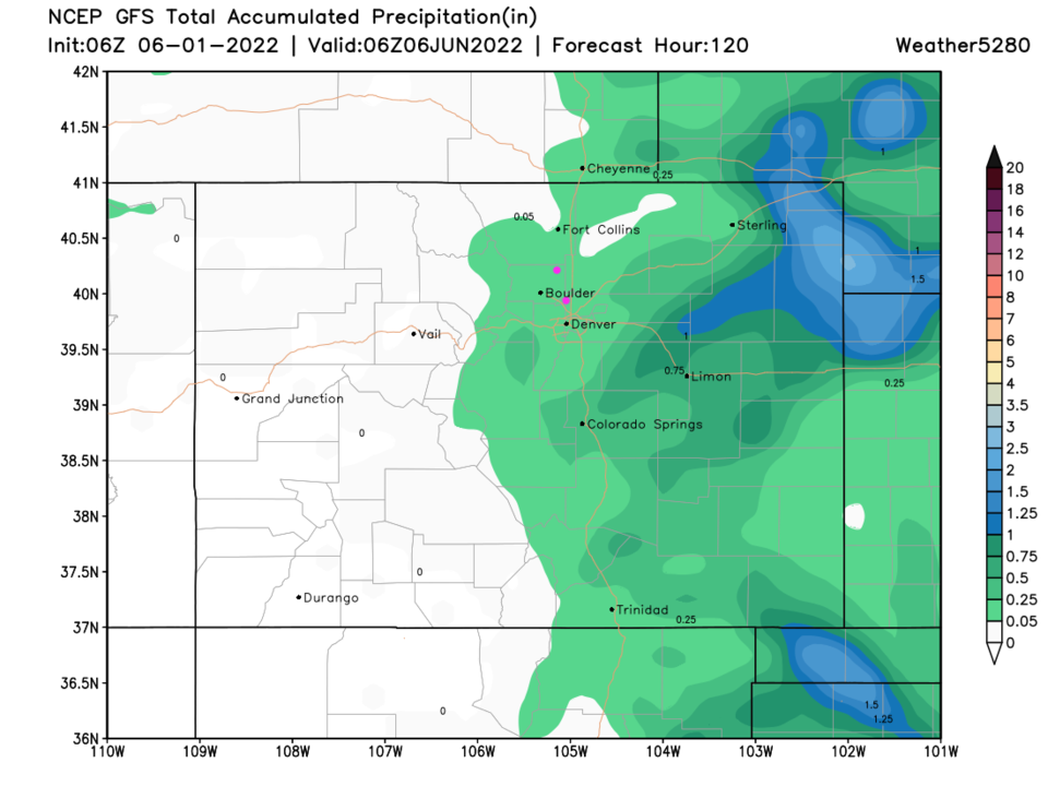
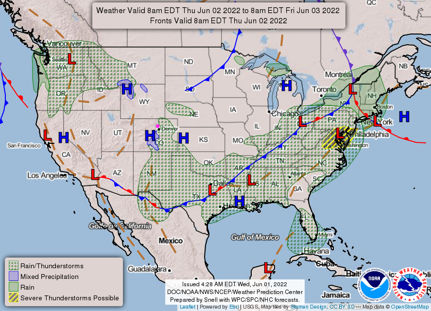
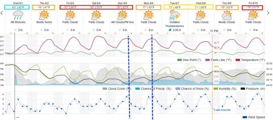
Thursday will warm a bit but remain mostly dry (Figure 3 and 4).

Figure1_06012022
Figure 1: 24 hour precipitation total from CoCoRaHS for Boulder Co.
Figure2_06012022
Figure 2: 24 hour precipitation total from CoCoRaHS for Broomfield Co.
Figure3_06012022
Figure 3: the 10 day graphical forecast for Denver from weatherunderground.com
Figure4_06012022
Figure 4: the Thursday surface analysis forecast from NOAA and the NWS.

The Longer Range Forecast:

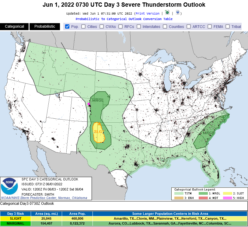
Precipitation chances pick up again Friday as temperatures rise and afternoon thunderstorms wander off the mountains.  There is a marginal risk of severe weather Friday - a few of those storms may reach severe limits (Figure 5).

A couple of weak fronts arrive Sunday and Monday lowering temperatures and raising precipitation chances (Figure 3). Over the next 5 days, what little precipitation falls will remain largely east of the Divide.

Figure5_06012022
Figure 5: the Day 3 (Friday) severe weather outlook from the SPC in Norman, OK
Figure6_06012022
Figure 6: the 5 day precipitation forecast from the GFS and weather5280.com


About the Author: John Ensworth

John Ensworth used to work from Longmont as the PI for the NASA through the IGES (The Institute for Global Environmental Strategies). He now teaches technology, algebra, astronomy, meteorology, film school, and Lego robotics to middle/high school.
Read more


Comments


Current Weather

Mostly cloudy

Mostly cloudy

37°F

UV Index
1 Low
Pressure
29.84 Steady
Visibility
8 miles
Dewpoint
30 °F
Humidity
75%
Wind
NNE 1.7 mph
Gust
3.5 mph
Wind Chill
37 °F

Hourly Forecast

Today
8 AM
39°F
Mostly cloudy
Today
9 AM
41°F
Intermittent clouds
Today
10 AM
44°F
Intermittent clouds
Today
11 AM
47°F
Intermittent clouds
Today
12 PM
49°F
Intermittent clouds
Today
1 PM
51°F
Intermittent clouds
Today
2 PM
52°F
Intermittent clouds
Today
3 PM
52°F
Intermittent clouds
Today
4 PM
51°F
Intermittent clouds
Today
5 PM
50°F
Intermittent clouds
Today
6 PM
47°F
Mostly cloudy w/ showers
Today
7 PM
44°F
Intermittent clouds

7 Day Forecast

Partly sunny w/ showers

Friday

52 °F

Cooler with sun and clouds; a couple of showers late this afternoon


Showers

Friday Night

34 °F

A couple of showers this evening; otherwise, cloudy


Mostly cloudy

Saturday

60 °F

Mostly cloudy


Intermittent clouds

Saturday Night

34 °F

Partly cloudy


Intermittent clouds

Sunday

62 °F

Periods of clouds and sun


Mostly cloudy

Sunday Night

33 °F

Becoming cloudy


Showers

Monday

52 °F

Cloudy and cooler with occasional rain; windy in the afternoon


Intermittent clouds

Monday Night

29 °F

Windy in the evening; partly cloudy


Mostly sunny

Tuesday

61 °F

Mostly sunny and milder


Clear

Tuesday Night

29 °F

Clear


Sunrise and Sunset

Sunrise
6:48 AM
Sunset
7:23 PM

Based on AccuWeather data