Skip to content

Wed Update:The Front Range Forecast: Smoke now, storms later

In Brief:

Smoke for a bit longer, clearer air and afternoon thunderstorms begin.

Wednesday Update:

Change is coming to the weather today! There is about a 40% chance of a thunderstorm this afternoon. There is also a chance that the storms today may reach severe levels with hail and high winds being the primary threat (Figure 1 update).  The air coming in behind these storms should be more from the southwest and noticeably improve our air quality, cleaning out the smoke from the ongoing Canadian fires.

We have a lower chance of thunderstorms on Thursday, and a better chance, again, on Friday.  The storms on these days may reach severe levels as well, with hail and high winds still the primary threat. But you'll be able to breath easier!

figure1u_05242023
Figure 1 update: the Day 1 SPC severe weather forecast for Wednesday.

End Wednesday update.

The Forecast Discussion:

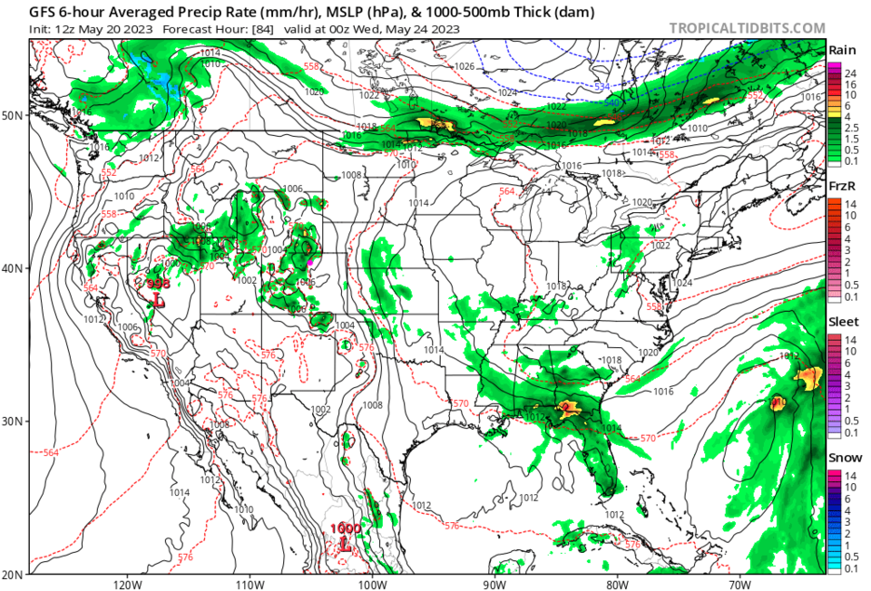
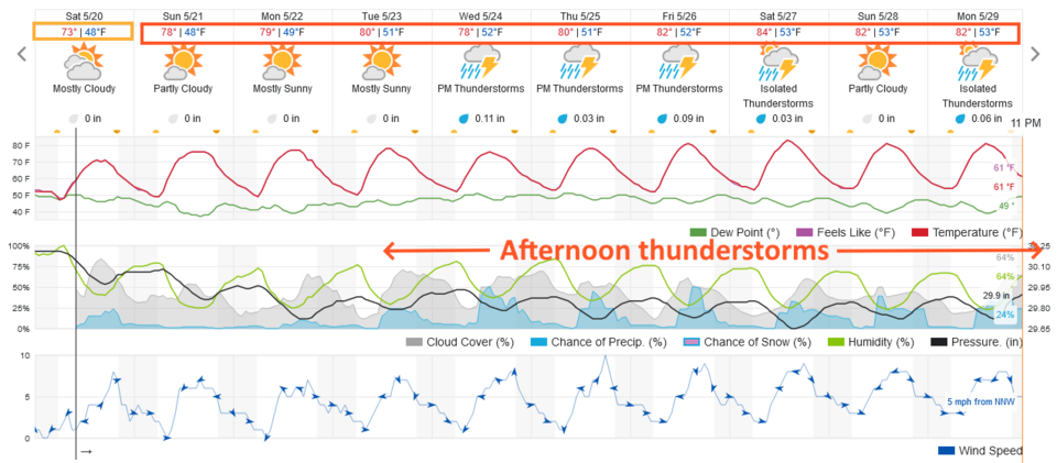
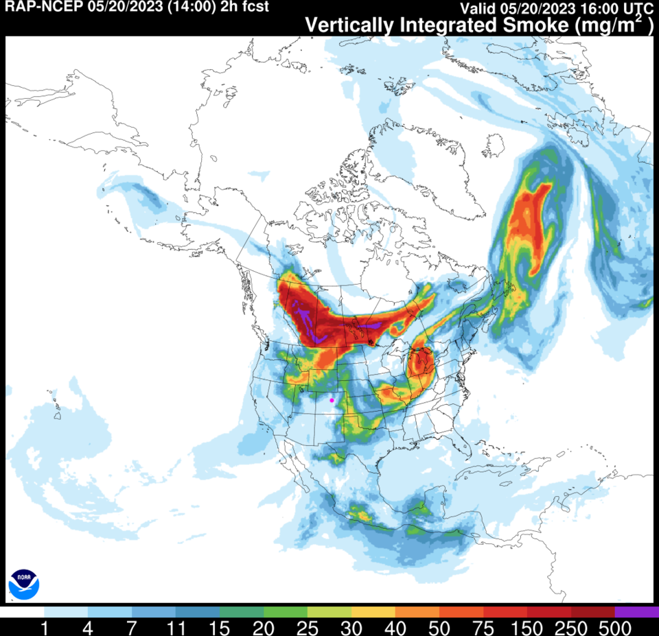
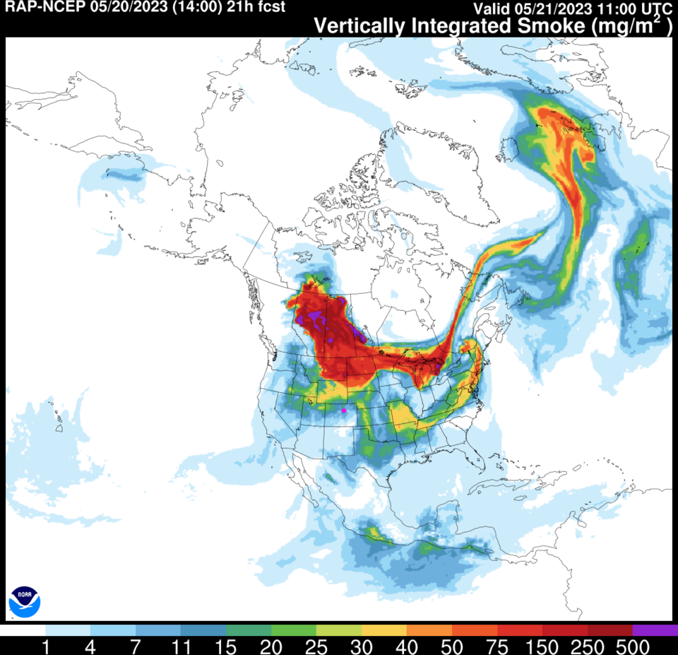
After a few Saturday afternoon showers, the weather turns calm for a couple of days (Figure 1). The real problem is smoke.  Giant forest fires in Canada (and Mexico) are pumping the westerlies full of smoke (Figure 2). By Sunday, another surge of very bad air is headed our way (Figure 3).  Eventually, westerly then southwesterly winds will clean the air by mid- week and later in the week.

figure1_05202023
Figure 1: the 10 day graphical forecast for Denver from weatherunderground.com
figure2_05202023
Figure 2: the RAP smoke forecast for Wednesday PM from NOAA.
figure3_05202023
Figure 3: the RAP smoke forecast for Thursday PM from NOAA.

The Longer Range forecast:

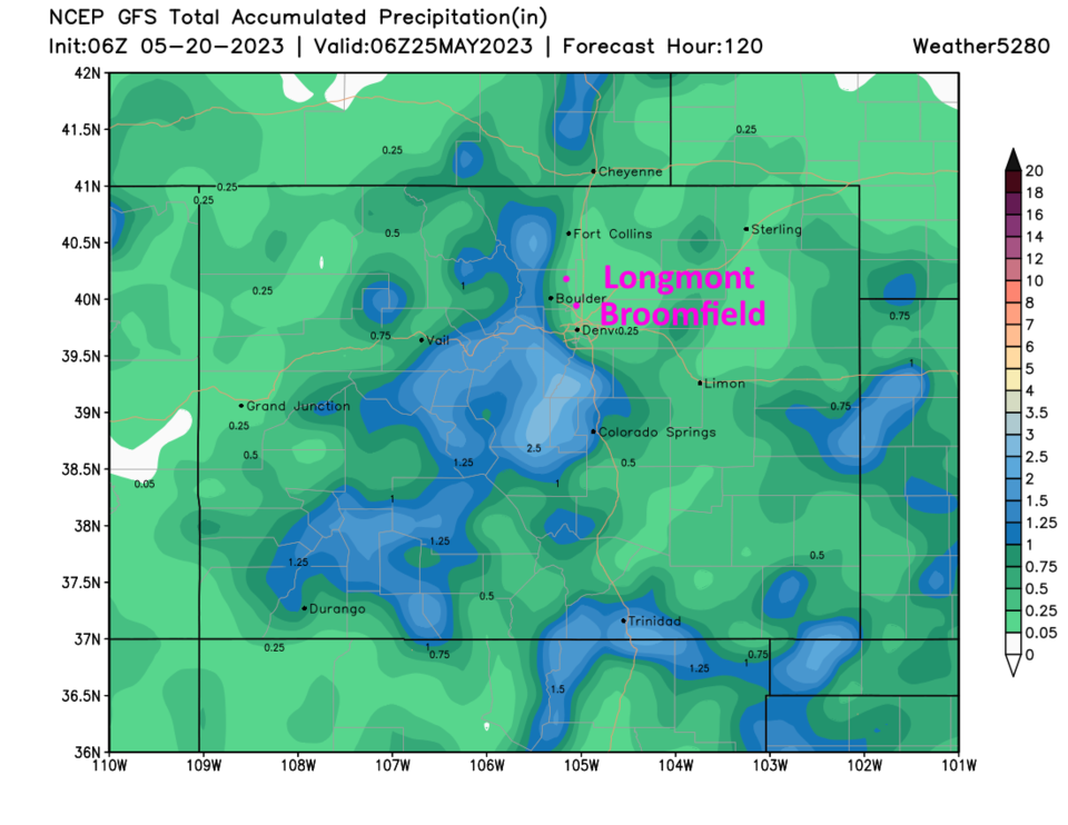
With increased tropical moisture and southerly winds, the smoke will clear and rain chances will increase in the afternoons starting Tuesday (Figure 4). Wandering storms will give the I-25 folks a tenth to a quarter of an inch of rain over the next 5 days - more rain for the mountains (Figure 5).

figure4_05202023
Figure 4: the surface precipitation forecast map for Tuesday PM from tropicaltidbits and the GFS model
figurer5_05202023
Figure 5: the 5 day precipitation forecast from the GFS and weather5280.com


About the Author: John Ensworth

John Ensworth used to work from Longmont as the PI for the NASA through the IGES (The Institute for Global Environmental Strategies). He now teaches technology, algebra, astronomy, meteorology, film school, and Lego robotics to middle/high school.
Read more


Comments


Current Weather

Cloudy

Cloudy

63°F

UV Index
0 Low
Pressure
30 Falling
Visibility
6 miles
Dewpoint
58 °F
Humidity
83%
Wind
NW 1.1 mph
Gust
2.2 mph
Wind Chill
63 °F

Hourly Forecast

Today
5 AM
62°F
Mostly clear
Today
6 AM
62°F
Mostly sunny
Today
7 AM
65°F
Mostly sunny
Today
8 AM
66°F
Mostly sunny
Today
9 AM
72°F
Mostly sunny
Today
10 AM
78°F
Partly sunny
Today
11 AM
83°F
Partly sunny
Today
12 PM
88°F
Partly sunny
Today
1 PM
90°F
Partly sunny
Today
2 PM
92°F
Partly sunny
Today
3 PM
90°F
Partly sunny
Today
4 PM
85°F
Partly sunny w/ t-storms

7 Day Forecast

Partly sunny w/ t-storms

Saturday

92 °F

Partly sunny with a heavy thunderstorm this afternoon; thunderstorms could bring damaging winds, flash flooding and hail


Partly cloudy w/ t-storms

Saturday Night

59 °F

A thundershower in spots this evening; otherwise, mainly clear


Mostly sunny

Sunday

98 °F

Mostly sunny and very warm


Clear

Sunday Night

56 °F

Clear


Sunny

Monday

100 °F

Hot with the temperature tying the record from 1995 with plenty of sunshine; caution advised if outside for extended periods of time


Clear

Monday Night

58 °F

Clear


Mostly sunny

Tuesday

103 °F

Mostly sunny and hot with the temperature approaching the record of 105 set in 1980; caution advised if outside for extended periods of time


Partly cloudy

Tuesday Night

62 °F

Partly cloudy


Sunny

Wednesday

103 °F

Sunshine and hot with the temperature breaking the record of 102 set in 2001; danger of dehydration and heatstroke if outside for extended periods of time


Clear

Wednesday Night

62 °F

Clear


Sunrise and Sunset

Sunrise
5:54 AM
Sunset
8:19 PM

Based on AccuWeather data