Skip to content
Join our Newsletter

Saturday Update: The Front Range Forecast: Snow Totals; Warm Up

In Brief:

Snow totals and much warmer soon!

Saturday Update:

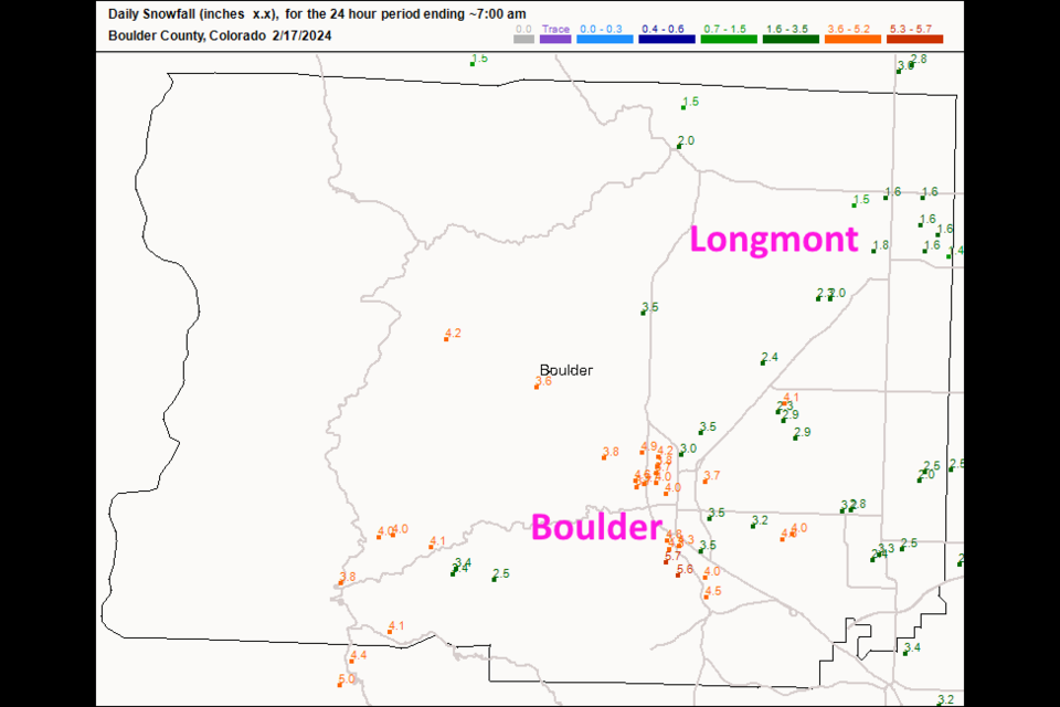
The forecast, below, was a good one for Colorado. Longmont received about 1.5 inches (Figure 1 update) while boulder got 3-5.7 inches.  By Tuesday, we will be up into the 60's.  Watch it melt! 

figure1u_02172024
Figure 1 update: 7am Saturday snow reports from CoCoRaHS

Ens Saturday update.

Forecast Discussion:

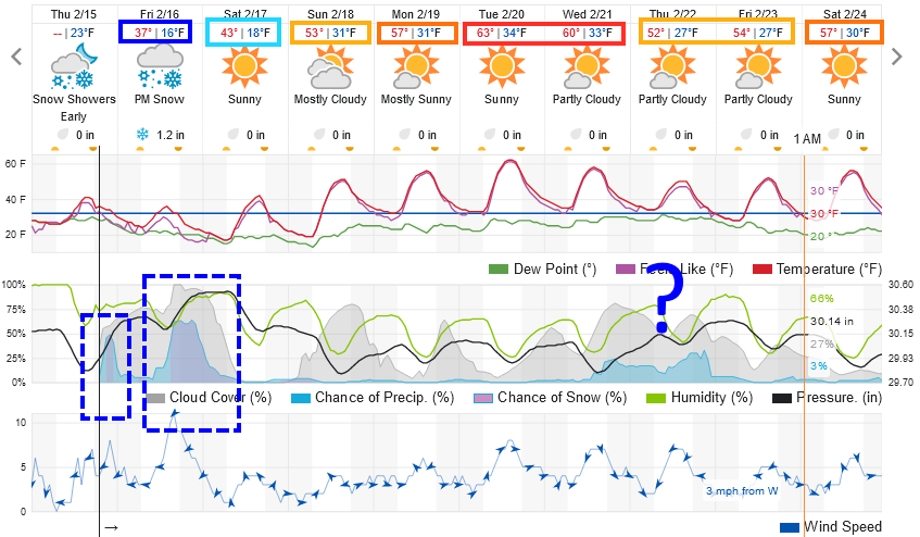
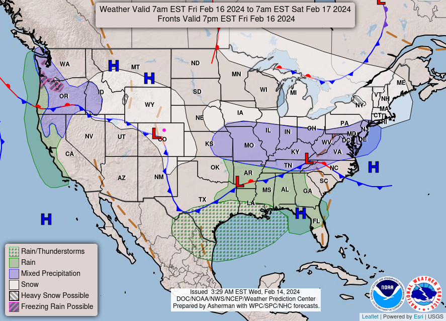
A cold front is on its way (it is parked near Cheyenne currently) for Friday. After a morning shot of light snow, snow or snow/rain mix chances begin to rise around 3pm and continue until after midnight Saturday morning (Figure 1). Much of Colorado will have snow chances with the front pushed up into the Rockies (Figure 2).

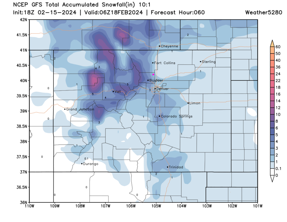
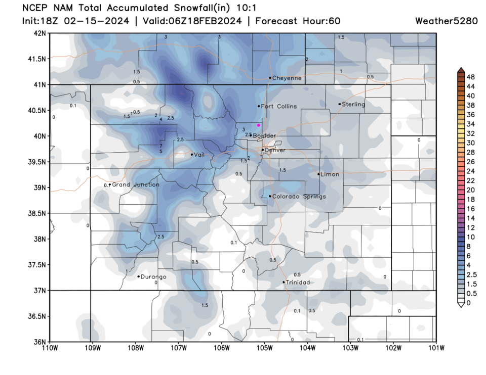
The weatherunderground model gives Longmont 1-2 inches of snow. The GFS gives us 1-3 inches with 3-5 inches in Boulder.  Snow totals increase quickly into the Foothills. The NAM 1-3 inches as well (Figure 4).

This doesn't look like a big or very cold storm.  Just a reminder that winter is still around.  You won't think that in the Longer Range forecast below...

figue1_02152024
Figure 1: the 10 day graphical forecast for Longmont from weatherunderground.com
figure2_02152024
Figure 2: the NWS surface forecast map for Friday.
figure3_02152024
Figure 3: the 10:1 snowfall ratio forecast for the next 2.5 days from the GFS and weather5280.com
figure4_02152024
Figure 4: the 10:1 snowfall ratio forecast for the next 2.5 days from the Canadian model and weather5280.com

The Longer Range Forecast:

The normal high temperature returns to the 50's in a week but actual highs will climb into the 60's!  There is a chance of rain or maybe snow towards the end of next week... more on that later!


About the Author: John Ensworth

John Ensworth used to work from Longmont as the PI for the NASA through the IGES (The Institute for Global Environmental Strategies). He now teaches technology, algebra, astronomy, meteorology, film school, and Lego robotics to middle/high school.
Read more


Comments


Current Weather

Mostly cloudy

Mostly cloudy

89°F

UV Index
1 Low
Pressure
30.03 Steady
Visibility
9 miles
Dewpoint
44 °F
Humidity
21%
Wind
E 3.5 mph
Gust
8.4 mph
Wind Chill
89 °F

Hourly Forecast

Today
5 PM
92°F
Showers
Today
6 PM
89°F
Cloudy
Today
7 PM
85°F
Cloudy
Today
8 PM
82°F
Intermittent clouds
Today
9 PM
78°F
Mostly cloudy w/ t-storms
Today
10 PM
74°F
Intermittent clouds
Today
11 PM
69°F
Intermittent clouds
Tomorrow
12 AM
68°F
Intermittent clouds
Tomorrow
1 AM
66°F
Intermittent clouds
Tomorrow
2 AM
66°F
Intermittent clouds
Tomorrow
3 AM
66°F
Intermittent clouds
Tomorrow
4 AM
65°F
Intermittent clouds

7 Day Forecast

Mostly cloudy w/ showers

Wednesday

92 °F

Turning cloudy, becoming breezy this afternoon with a shower in spots; thunderstorms can bring localized damaging wind gusts


Partly cloudy w/ t-storms

Wednesday Night

61 °F

A thunderstorm this evening; otherwise, partly cloudy


Partly sunny w/ t-storms

Thursday

86 °F

Sunshine mixing with clouds with a thunderstorm in spots in the afternoon; thunderstorms can bring localized damaging wind gusts, hail and flooding downpours


Partly cloudy w/ t-storms

Thursday Night

57 °F

A thunderstorm in spots in the evening; otherwise, partly cloudy


Thunderstorms

Friday

81 °F

Mostly cloudy with a thunderstorm in spots in the afternoon


Intermittent clouds

Friday Night

55 °F

Partly cloudy


Mostly cloudy

Saturday

78 °F

Rather cloudy with a thunderstorm in spots in the afternoon


Mostly cloudy

Saturday Night

50 °F

Mostly cloudy


Mostly sunny

Sunday

82 °F

Sunshine and a few clouds


Clear

Sunday Night

49 °F

Clear


Sunrise and Sunset

Sunrise
6:36 AM
Sunset
7:18 PM

Based on AccuWeather data