Skip to content
Join our Newsletter

Friday Update: The Front Range Forecast: Snow in the New Year?

In Brief:

The New Year brings a few chances of snow this week.

Friday update:

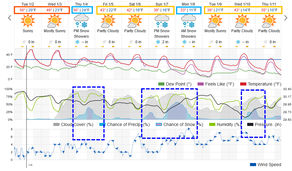
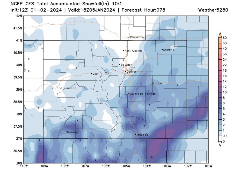
We stay near normal for high temperatures this week (hovering near the low 40's). Figure 1 update shows mountain snow over the next three days. Areas near I-25 and the foothills won't see much in the way of measurable snow. Sorry, winter is moving on quietly.

figure3u_01052024
Figure 1 update: the 10:1 ratio snowfall forecast from the GFS and weather5280.com over the next 3 days.

End Friday update.

Forecast Discussion:

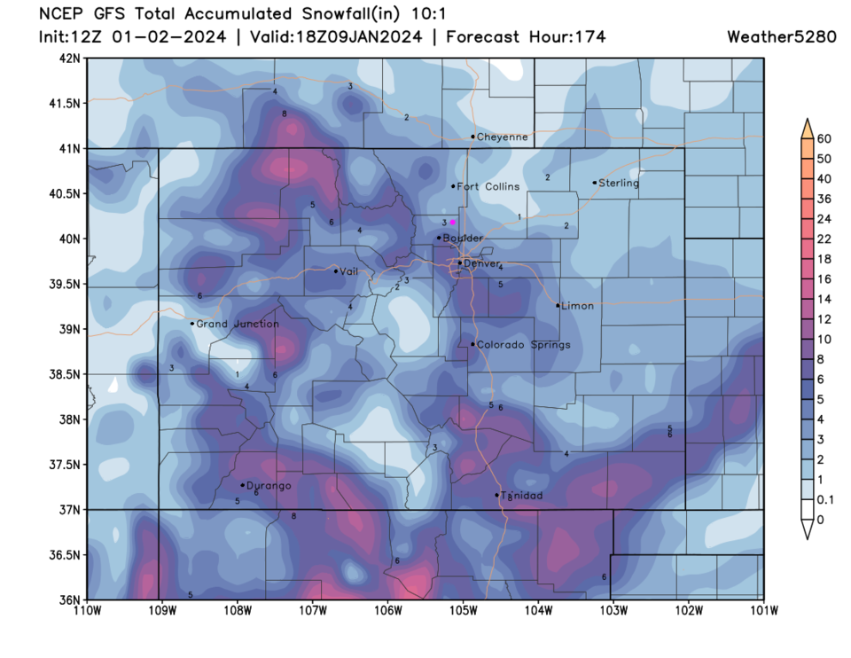
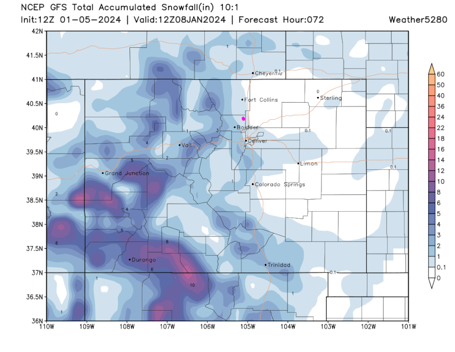
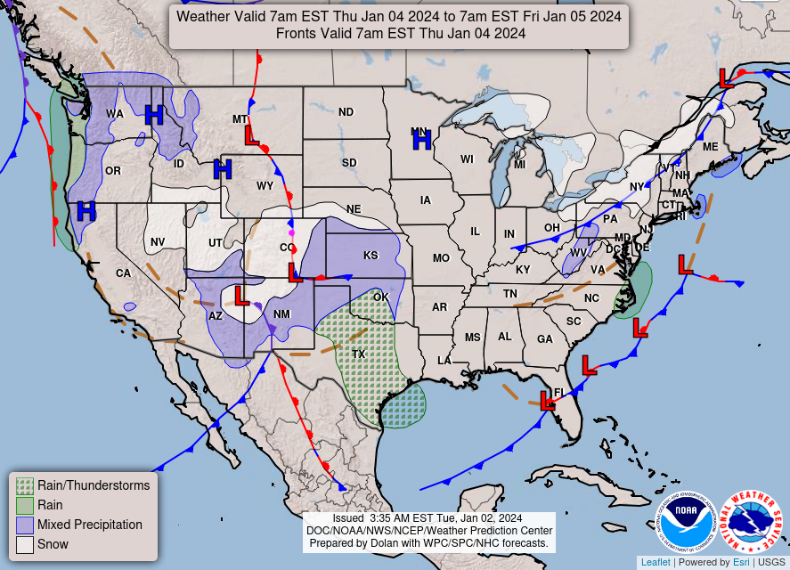
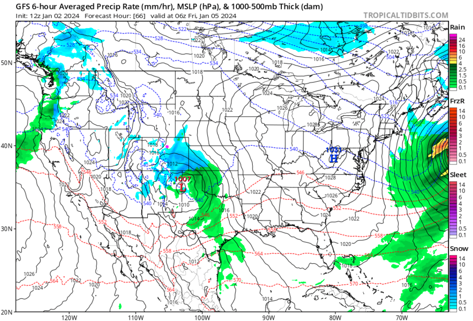
We start the year still quite warm and dry (Figure 1). Thursday will see our next chance of precipitation. The National Weather Service (Figure 2) has things quite over-covered with snow, but it shows the low on the CO and NM border. The GFS has the low further south and the heavier snow down south as well (Figure 3).  That same model skips the I-25 corridor and drops measurable snow to areas southeast of Denver this time (Figure 4).

Temperatures return to normal on Friday.

figure1_01022024
Figure 1: The 10 day graphical forecast for Longmont from weatherunderground.com
figure2_01022024
Figure 2: the NWS surface weather forecast map for Friday AM.
figure3_01022024
Figure 3: the surface weather forecast map from the GFS and tropicaltidbits.com for Sun/Mon midnight
figure4_01022024
Figure 4: the three day 10:1 ratio snowfall forecast from the GFS and weather5280.com

The Longer Range Forecast:

The next system moves in late Saturday night with a better chance of snow Sunday afternoon/night (Figure 1). This low is further north creating upslope flow in northern Colorado and Wyoming. Areas around I-25 may see 1-3 inches this time with a half foot to a foot in mountain locations (Figure 6).  Then there is a hint of another system beyond that.  I'll update on these next storms later!

figure5_01022024
Figure 5: the surface weather forecast map from the GFS and tropicaltidbits.com for Thurs/Fri midnight
figure6_01022024
Figure 6: the seven day 10:1 ratio snowfall forecast from the GFS and weather5280.com


About the Author: John Ensworth

John Ensworth used to work from Longmont as the PI for the NASA through the IGES (The Institute for Global Environmental Strategies). He now teaches technology, algebra, astronomy, meteorology, film school, and Lego robotics to middle/high school.
Read more


Comments


Current Weather

Mostly cloudy

Mostly cloudy

48°F

UV Index
0 Low
Pressure
29.79 Steady
Visibility
8 miles
Dewpoint
44 °F
Humidity
86%
Wind
N 1.8 mph
Gust
3.5 mph
Wind Chill
48 °F

Hourly Forecast

Today
6 AM
48°F
Mostly cloudy w/ showers
Today
7 AM
50°F
Intermittent clouds
Today
8 AM
55°F
Mostly cloudy
Today
9 AM
57°F
Mostly cloudy
Today
10 AM
60°F
Mostly cloudy
Today
11 AM
62°F
Mostly cloudy
Today
12 PM
64°F
Cloudy
Today
1 PM
64°F
Cloudy
Today
2 PM
64°F
Cloudy
Today
3 PM
64°F
Cloudy
Today
4 PM
61°F
Thunderstorms
Today
5 PM
58°F
Cloudy

7 Day Forecast

Mostly cloudy w/ t-storms

Sunday

64 °F

Cooler with variable clouds; breezy this afternoon with showers and a heavier t-storm; thunderstorms can bring flooding downpours, hail and damaging wind gusts


Mostly cloudy w/ t-storms

Sunday Night

47 °F

A thunderstorm on the prowl this evening; otherwise, increasing clouds


Intermittent clouds

Monday

65 °F

Times of clouds and sun


Cloudy

Monday Night

40 °F

Cloudy


Mostly cloudy

Tuesday

72 °F

Cloudy in the morning, then intervals of clouds and sunshine in the afternoon


Mostly clear

Tuesday Night

44 °F

Mainly clear


Mostly sunny

Wednesday

78 °F

Mostly sunny and nice


Mostly clear

Wednesday Night

42 °F

Mainly clear


Mostly sunny

Thursday

77 °F

Mostly sunny


Mostly clear

Thursday Night

48 °F

Mainly clear


Sunrise and Sunset

Sunrise
5:42 AM
Sunset
8:12 PM

Based on AccuWeather data