Skip to content
Join our Newsletter

Wed Update: The Front Range Forecast: Snow totals, warmth ahead

In Brief:

Snow totals and a real warm up coming!

Wednesday Update:

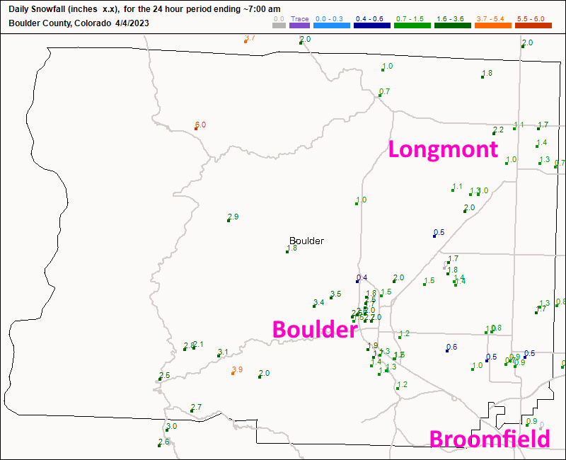
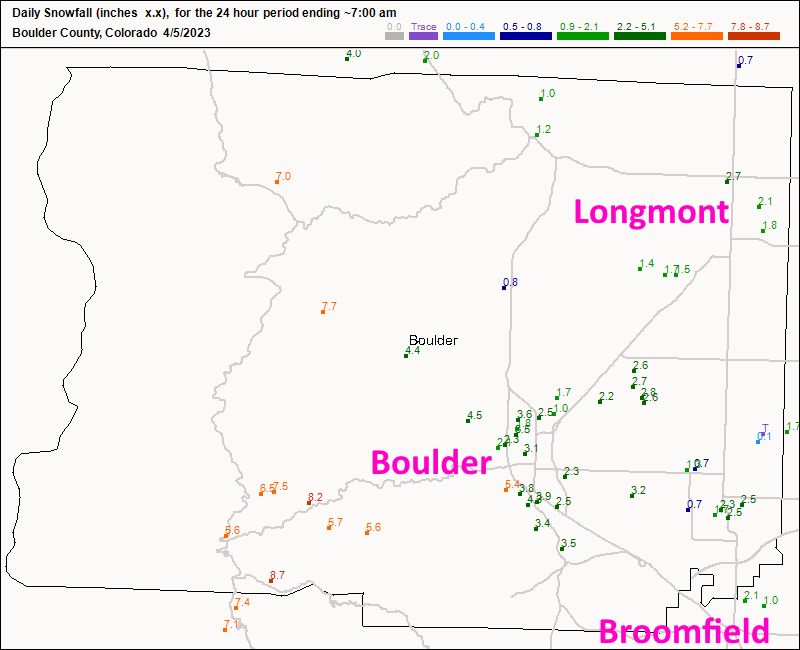
Confession, I thought THIS storm would be quite minor as well.  It turned out to be more significant than major models supported until overnight before the snow began.  Figures 1 update and 2 update show that Longmont received about 3.5 inches over a day of time.  The snow compacted and melted so there never was more than about 1-2 inches on the ground at one time. Still, travel was a mess!

We now warm up quickly and "may" get close to or break 80F Monday/Tuesday next week.  More later!

figure1u_04052023
Figure 1 update: the new snowfall totals (10:1 ratio) up to Tuesday 7am - from CoCoRaHS.com.
figure2u_04052023
Figure 2 update: the new snowfall totals (10:1 ratio) up to Wednesday 7am - from CoCoRaHS.com.

End Wednesday update:

Forecast Discussion:

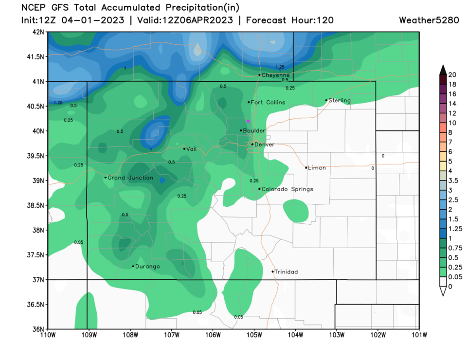
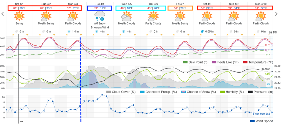
We get another beautiful weekend (except for wind and fire danger at times). A cold front arrives Monday afternoon with a rapid drop in temperatures and increase in precipitation chances (Figure 1).  It should start out as rain changing to snow overnight. You can see the cold front and approaching precipitation in Figure 2.  At present we should see 1-2 inches along I-25. I'll update here if snow amounts look like they will pile up more (like our last storm).

figure1_04012023
Figure 1: The 10 day graphical forecast for Denver from weatherunderground.com
figure2_04012023
Figure 2: the NWS surface forecast map for Monday.

The Longer Range Forecast:

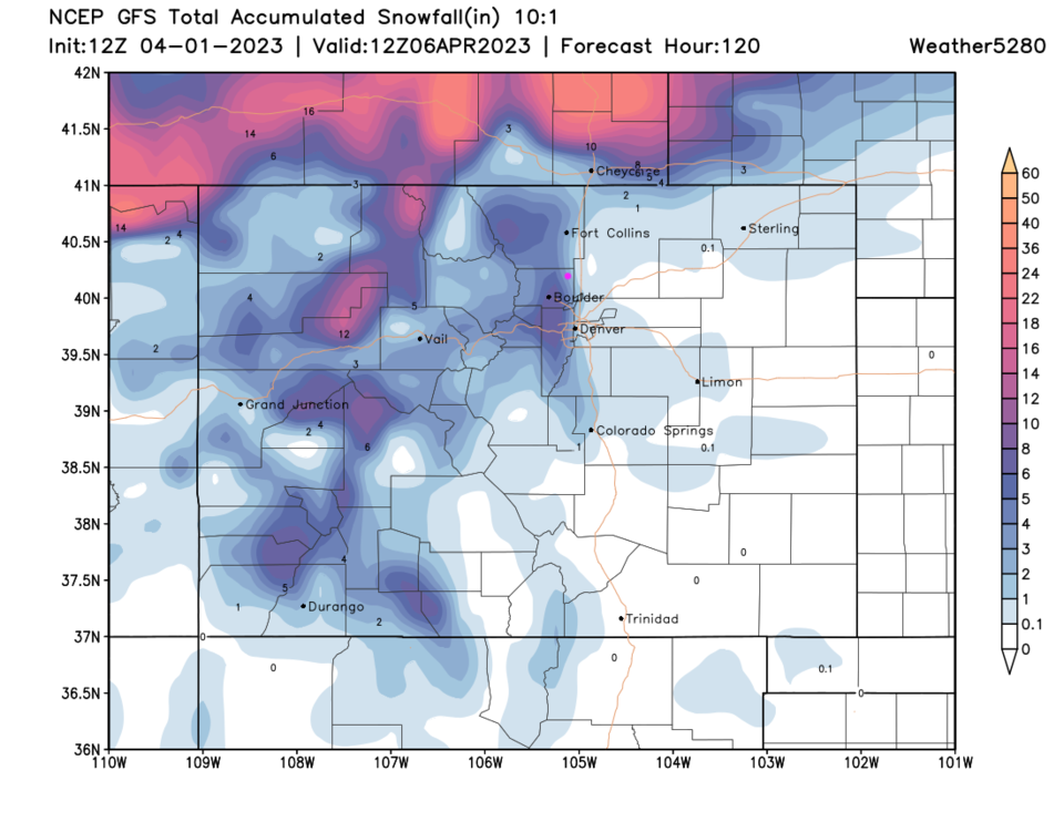
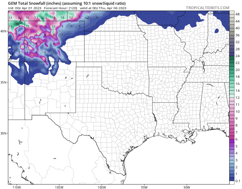
A second, and at present smaller, storm arrives on Wednesday/Thursday (of course - Figure 1). These two systems drop between 1/4th and 1/2th inch of liquid on the I-25 corridor (Figure 3). The GFS gives us a total, for the two systems, of 1-3 inches (Figure 4) while the GFS hints at for 3-5 inches (Figure 5).  These systems are still quite a ways out.  I'll keep you updated here!

By end of the week we are dry again with Spring temperatures returning.

figure3_04012023
Figure 3: the 5 day precipitation forecast from the GFS and weather5280.com
figure4_04012023
Figure 4: the 5 day precipitation forecast from the GFS and weather5280.com
figure5_04012023
Figure 5: the 5 day precipitation forecast from the Canadian model and tropicaltidbits.com


About the Author: John Ensworth

John Ensworth used to work from Longmont as the PI for the NASA through the IGES (The Institute for Global Environmental Strategies). He now teaches technology, algebra, astronomy, meteorology, film school, and Lego robotics to middle/high school.
Read more


Comments


Current Weather

Cloudy

Cloudy

55°F

UV Index
1 Low
Pressure
30.1 Steady
Visibility
8 miles
Dewpoint
51 °F
Humidity
86%
Wind
NE 5.5 mph
Gust
11 mph
Wind Chill
55 °F

Hourly Forecast

Today
5 PM
58°F
Thunderstorms
Today
6 PM
57°F
Thunderstorms
Today
7 PM
57°F
Thunderstorms
Today
8 PM
57°F
Cloudy
Today
9 PM
56°F
Cloudy
Today
10 PM
55°F
Cloudy
Today
11 PM
54°F
Thunderstorms
Tomorrow
12 AM
54°F
Thunderstorms
Tomorrow
1 AM
54°F
Cloudy
Tomorrow
2 AM
53°F
Thunderstorms
Tomorrow
3 AM
53°F
Cloudy
Tomorrow
4 AM
53°F
Thunderstorms

7 Day Forecast

Rain

Saturday

61 °F

Cooler; a shower in spots this morning followed by rain and a thunderstorm this afternoon; thunderstorms can bring hail and damaging winds


Rain

Saturday Night

52 °F

Overcast with occasional rain and a thunderstorm; thunderstorms can bring hail and damaging winds


Thunderstorms

Sunday

61 °F

Cool; a morning shower in spots followed by a couple of thunderstorms in the afternoon; thunderstorms can bring hail and damaging winds


Thunderstorms

Sunday Night

50 °F

A thunderstorm in the area in the evening; otherwise, low clouds


Thunderstorms

Monday

60 °F

Cloudy and cool; an afternoon thunderstorm in the area


Mostly cloudy

Monday Night

47 °F

Mostly cloudy


Intermittent clouds

Tuesday

74 °F

Warmer with times of clouds and sun; a thunderstorm in the area late in the afternoon


Partly cloudy

Tuesday Night

48 °F

Partly cloudy


Cloudy

Wednesday

68 °F

Cloudy with a thunderstorm in the afternoon


Cloudy

Wednesday Night

49 °F

Cloudy with a thunderstorm in a couple of spots


Sunrise and Sunset

Sunrise
5:38 AM
Sunset
8:17 PM

Based on AccuWeather data