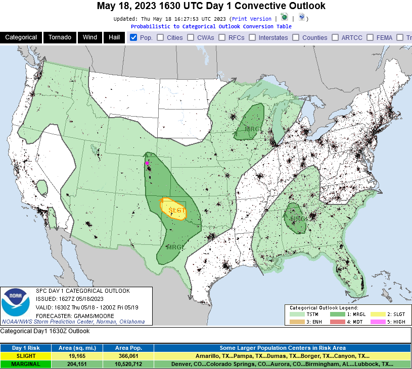
Skip to content

Fri Update: The Front Range Forecast: Rain totals, spring ahead

In Brief:

Rainfall totals!  Spring weather ahead.

Friday Update:

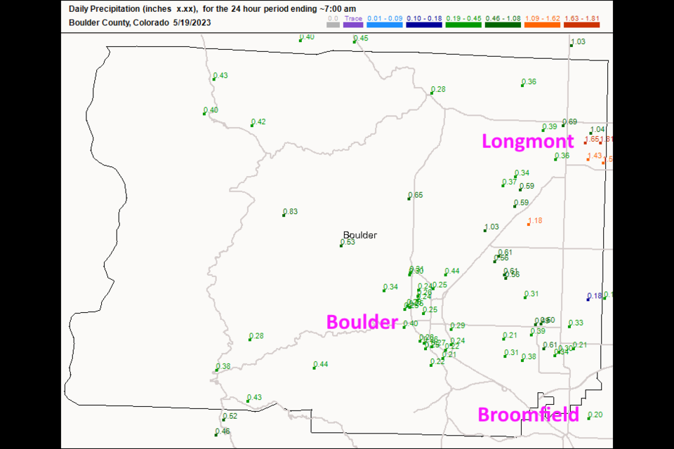
That was quite a storm!  It hit eastern Longmont, sat there for a bit, dropped around 1.5 inches of rain, and coated the ground with a layer of pea sized hail in spots (Figure 2 update). Other communities in Boulder county received around a quarter to a third of an inch. It will be quiet for a couple days as temperatures warm then we get into a pattern where afternoon thunderstorms are a good possibility every day (Figure 3 update).  Keep an eye out for severe weather chances again - it is the season.

figure3u_05192023
Figure 2 update: the CoCoRaHS rainfall report up to 7am Friday.
figure2u_05192023
Figure 3 update: the 10 day graphical forecast for Denver from weatherunderground.com

End Friday update.

Thursday update:

Today will be the wettest day for a bit, though daily thunderstorm and showers will effect the area. There IS a Marginal risk of severe weather, a 1 on a scale of 1-5. The primary risk will be for damaging hail. This includes the Front Range foothills and all I-25 cities.  Watch for those dark skies to the west - storm motion is almost directly west to east, overall, today.

figure1u_05182023
Figure 1 update: the severe weather forecast map from the NWS and the SPC.

End Thursday update.

Forecast Discussion:

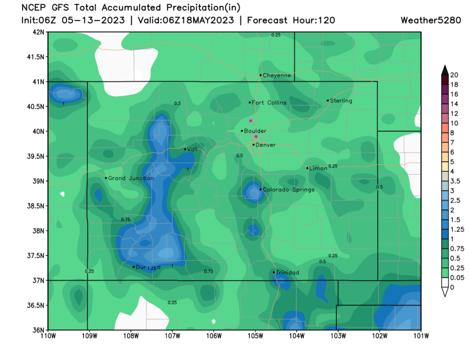
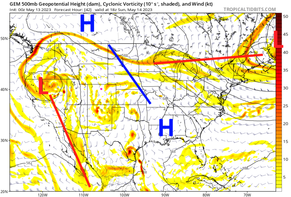
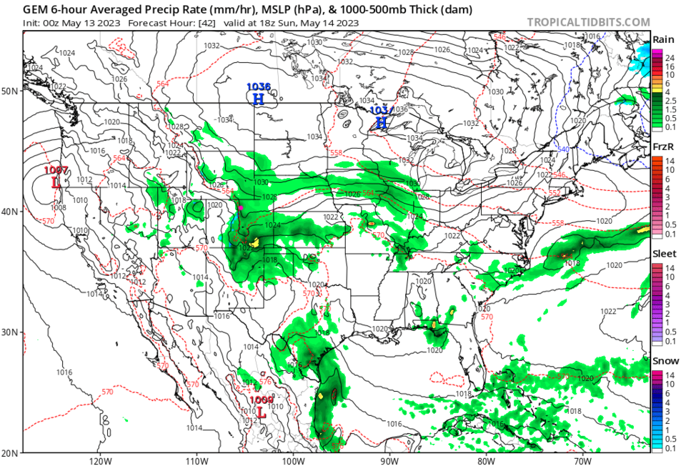
We have a brief break Saturday with ridging (high pressure) overhead.  Part of the low that gave us our record rains this week broke off and traveled westward (Figure 2) back towards the California coast.  A low to the south is heading northward to give us a period of upslope flow and rain centered (Figure 3) on Sunday (Figure 1). This is a weird atmospheric pattern.  I think our brief return of drought conditions is solved now.


figure1_05132023
Figure 1: the 10 day graphical forecast for Denver from weatherunderground.com
figure2_05132023
Figure 2: the 500mb upper air map for Sunday noon from the GFS and tropicaltidbits.com
figure3_05132023
Figure 3: the surface precipitation and pressure map for Sunday noon from the GFS and tropicaltidbits.com

The Longer Range Forecast:

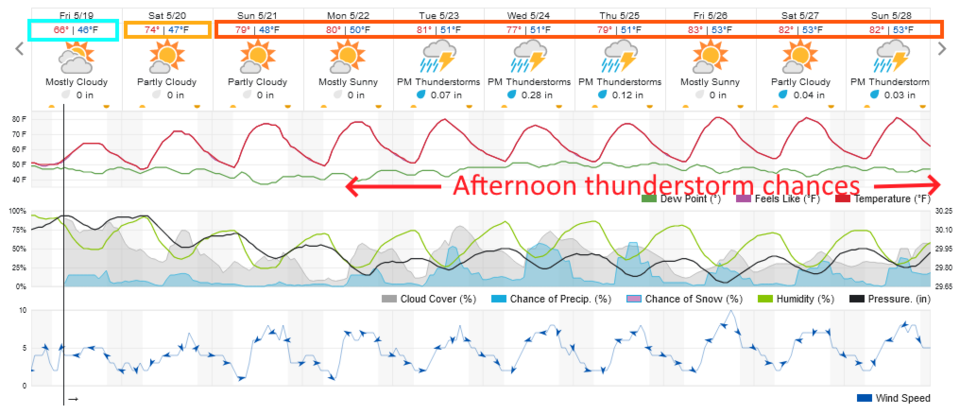
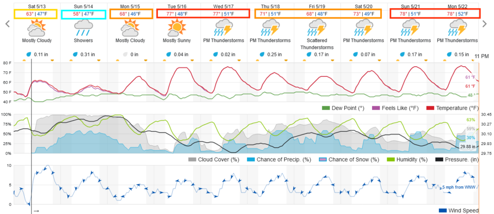
With plenty of atmospheric moisture, daytime heating will kick off thunderstorm chances every afternoon (Figure 1). Over the next 5 days, the front range communities may see a quarter to a half inch of additional precipitation (Figure 4). A very Colorado spring!

figure4_05132023
Figure 4: the 5 day precipitation total forecast from the GFS and weather5280.com


About the Author: John Ensworth

John Ensworth used to work from Longmont as the PI for the NASA through the IGES (The Institute for Global Environmental Strategies). He now teaches technology, algebra, astronomy, meteorology, film school, and Lego robotics to middle/high school.
Read more


Comments


Current Weather

Cloudy

Cloudy

50°F

UV Index
0 Low
Pressure
29.76 Falling
Visibility
8 miles
Dewpoint
27 °F
Humidity
41%
Wind
SSW 3.2 mph
Gust
6.5 mph
Wind Chill
50 °F

Hourly Forecast

Tomorrow
12 AM
45°F
Showers
Tomorrow
1 AM
43°F
Intermittent clouds
Tomorrow
2 AM
41°F
Intermittent clouds
Tomorrow
3 AM
39°F
Intermittent clouds
Tomorrow
4 AM
37°F
Intermittent clouds
Tomorrow
5 AM
36°F
Intermittent clouds
Tomorrow
6 AM
34°F
Intermittent clouds
Tomorrow
7 AM
35°F
Intermittent clouds
Tomorrow
8 AM
38°F
Intermittent clouds
Tomorrow
9 AM
41°F
Intermittent clouds
Tomorrow
10 AM
44°F
Intermittent clouds
Tomorrow
11 AM
47°F
Intermittent clouds

7 Day Forecast

Partly sunny

Thursday

65 °F

Partly sunny


Intermittent clouds

Thursday Night

34 °F

A shower in spots late this evening; otherwise, partly cloudy


Partly sunny w/ showers

Friday

53 °F

Cooler with times of clouds and sun; a couple of showers late in the afternoon


Showers

Friday Night

33 °F

A couple of showers in the evening; otherwise, cloudy


Mostly cloudy

Saturday

60 °F

Mostly cloudy


Intermittent clouds

Saturday Night

36 °F

Partly cloudy


Intermittent clouds

Sunday

62 °F

Times of sun and clouds


Mostly cloudy

Sunday Night

33 °F

Becoming cloudy


Showers

Monday

52 °F

Cloudy and cooler with occasional rain; windy in the afternoon


Intermittent clouds

Monday Night

29 °F

Windy in the evening; partly cloudy


Sunrise and Sunset

Sunrise
6:50 AM
Sunset
7:22 PM

Based on AccuWeather data