Skip to content
Join our Newsletter

Sun Update: The Front Range Forecast: Warm and dry for the start

Figure2u_09252022
Figure 3 update: the NHC forecast for Hurricane Ian.

In Brief:

A warm dry week cooled by weak fronts that bring showers at the end.

Sunday Update:

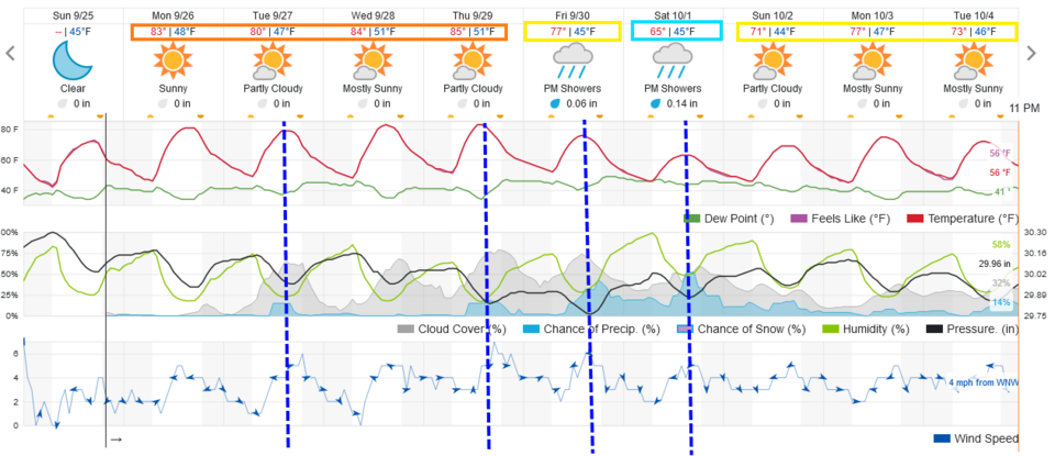
Things remain cool and quiet around Longmont and Broomfield. We will be a bit warmer than normal (in the 70's now) through mid-week. A series of weak cool fronts will moderate temperatures a bit on Tuesday, then more so going into next weekend (Figure 2 update). We don't see fair rainfall chances (except Tuesday) return until the weekend.

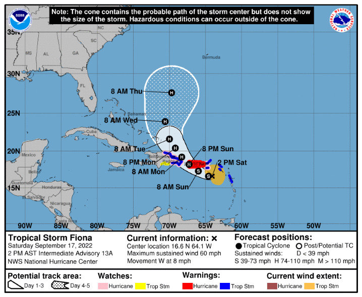
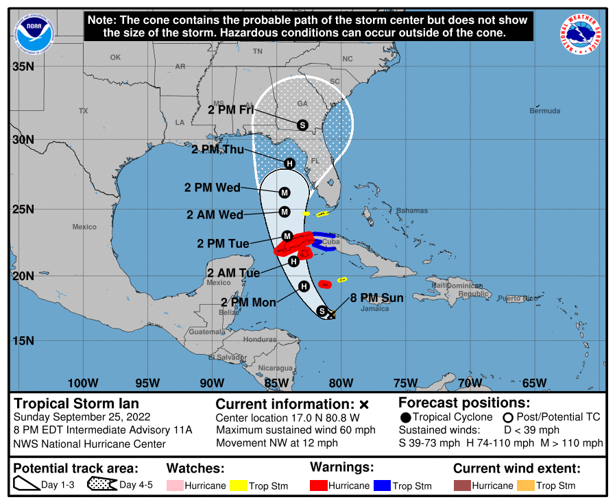
In my weather video this week at Longmont Public Media, I predicted a major eastern Gulf of Mexico hurricane this week.  The next name in line was Hermine. But a minimal tropical storm formed and lasted 48 hours near the Canary Islands that grabbed that name. Tropical Storm Ian is predicted to become a major storm making landfall somewhere in western Florida around Thursday PM (Figure 3 update). This will be a news maker.

Figure1u_09252022
Figure 2 update: the 10 day graphical forecast for Denver from weatherunderground.com
Figure2u_09252022
Figure 3 update: the NHC forecast for Hurricane Ian.

End Sunday update.

Tuesday Update:

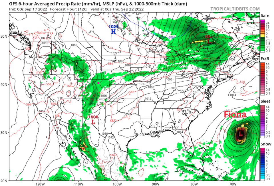
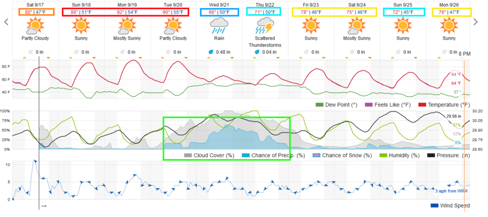
The initial cold front will pass around 5pm Tuesday. There are small rain chances overnight but the more steady rain should begin after noon Wednesday when a secondary cold front push comes through. Rain chances start to drop again around noon Thursday. Total precipitation around a quarter to a half inch should hit around Longmont and Broomfield (Figure 1 update). Highs should remain in the lower 60'sF Wednesday and Thursday.

Enjoy the right-on-time taste of Fall!

Figure1u_09202022
Figure 1 update: precipitation forecast for the next 4 days from the GFS and weather5280.com


End Tuesday update.

Forecast Discussion:

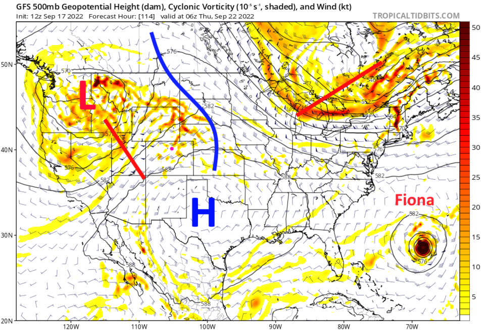
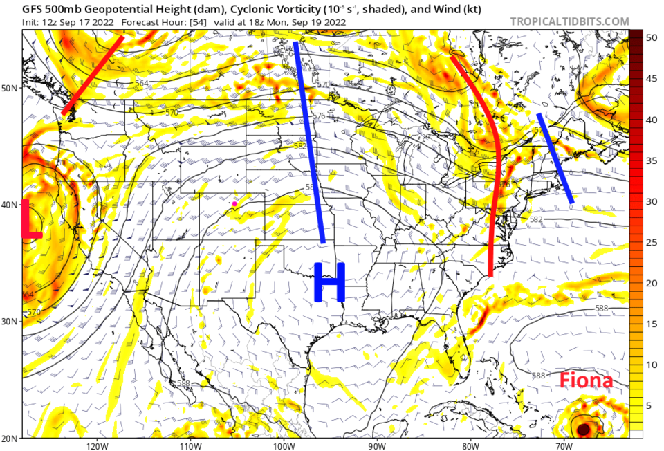
Hold on, the end of summer is in sight.  We may still get a couple of additional 90F days this year. A strong front arrives Tuesday evening dropping temperatures about 25F (Figure 1). The heat we have now comes from the giant high pressure dome over the middle of the nation (Figure 2).

Figure1_09172022
Figure 1: the 10 day graphical forecast for Denver.
Figure2_09172022
Figure 2: the 500mb upper air forecast map for Monday noon from the GFS and tropicaltidbits.com

The Longer Range Forecast:

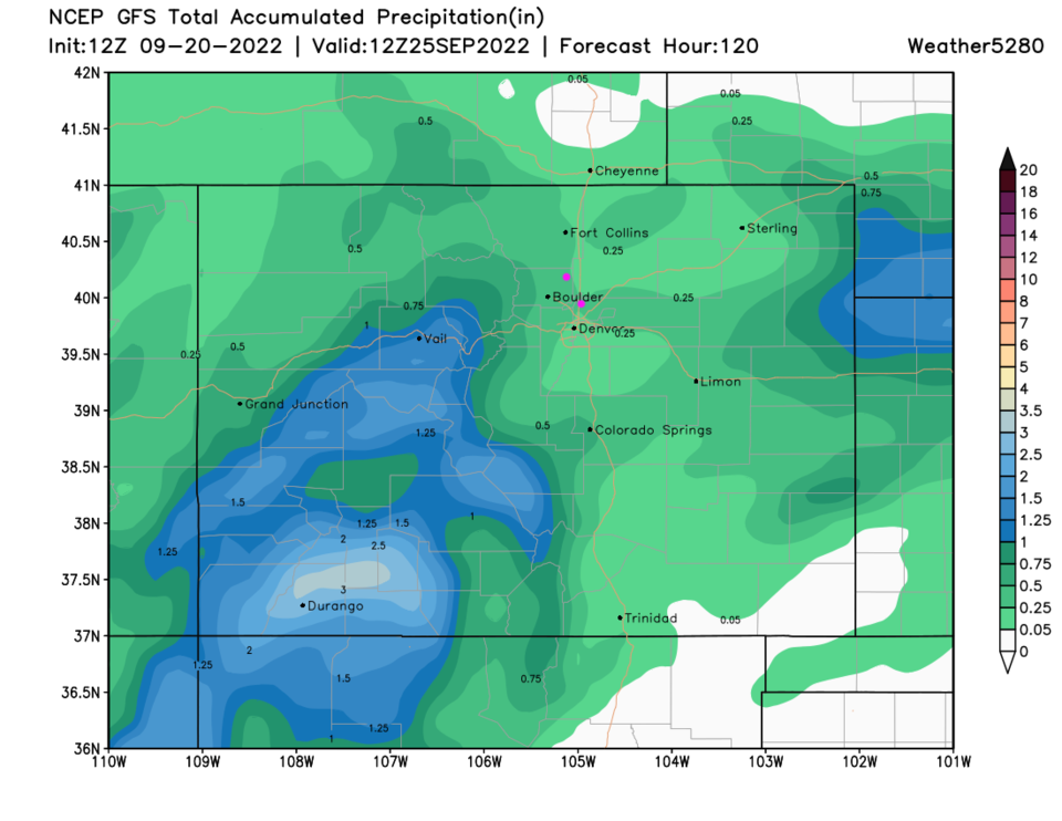
Changes of showers pick up slowly after the front with a mostly wet/drizzly Wednesday with a few storms Thursday (Figure 1). The high doesn't move much (very stubborn) but a trough digs in hard from the northwest (Figure 3). Showers will stretch across Colorado ahead of this trough (Figure 4).

Rainfall over the next 5 (and 10, shown in Figure 5), unfortunately remains heaviest to the west of the Divide.

Fall Arrives!

Fall officially begins (astronomically) September 22, 2022 at 7:04PM.  That is within a day of when it begins to "Feel" like Fall as well. Enjoy!

Tropical Update:

Hurricane Fiona, discussed in this week's video forecast at Longmont Public Media, is, happily, predicted to curve away from the U.S. and remain out to sea (Figure 6).

Figure3_09172022
Figure 3: the 500mb upper air forecast map for Thursday early morning from the GFS and tropicaltidbits.com
Figure4_09172022
Figure 4: the 6 hour precipitation forecast for early morning Thursday from tropicaltidbits and the GFS.
Figure6_09172022
Figure 6: The NHC forecast for Hurricane Fiona.


About the Author: John Ensworth

John Ensworth used to work from Longmont as the PI for the NASA through the IGES (The Institute for Global Environmental Strategies). He now teaches technology, algebra, astronomy, meteorology, film school, and Lego robotics to middle/high school.
Read more


Comments


Current Weather

Partly sunny

Partly sunny

81°F

UV Index
2 Low
Pressure
30.13 Falling
Visibility
8 miles
Dewpoint
58 °F
Humidity
47%
Wind
ENE 2.2 mph
Gust
5.3 mph
Wind Chill
81 °F

Hourly Forecast

Today
4 PM
83°F
Mostly cloudy w/ showers
Today
5 PM
84°F
Intermittent clouds
Today
6 PM
82°F
Intermittent clouds
Today
7 PM
79°F
Intermittent clouds
Today
8 PM
79°F
Intermittent clouds
Today
9 PM
76°F
Partly cloudy
Today
10 PM
72°F
Partly cloudy
Today
11 PM
69°F
Intermittent clouds
Tomorrow
12 AM
67°F
Intermittent clouds
Tomorrow
1 AM
65°F
Partly cloudy
Tomorrow
2 AM
64°F
Mostly clear
Tomorrow
3 AM
63°F
Clear

7 Day Forecast

Mostly cloudy w/ showers

Saturday

84 °F

Clouds and breaks of sun with a shower in places this afternoon; high levels of ozone will lead to poor air quality


Partly cloudy

Saturday Night

58 °F

Partly cloudy


Partly sunny w/ showers

Sunday

94 °F

Partly sunny with a passing shower in the afternoon


Partly cloudy

Sunday Night

61 °F

Partly cloudy


Mostly cloudy

Monday

94 °F

Considerable cloudiness


Mostly clear

Monday Night

60 °F

Clear to partly cloudy


Intermittent clouds

Tuesday

92 °F

Sun through high clouds


Partly cloudy

Tuesday Night

60 °F

Partly cloudy


Intermittent clouds

Wednesday

81 °F

Not as warm with times of clouds and sun; a thunderstorm in spots in the afternoon


Intermittent clouds

Wednesday Night

58 °F

An evening thunderstorm; otherwise, partly cloudy


Sunrise and Sunset

Sunrise
5:41 AM
Sunset
8:30 PM

Based on AccuWeather data