Skip to content

Fri Update: The Front Range Forecast: Snow totals, warm up

In Brief:

The warm up begins.

Friday update:

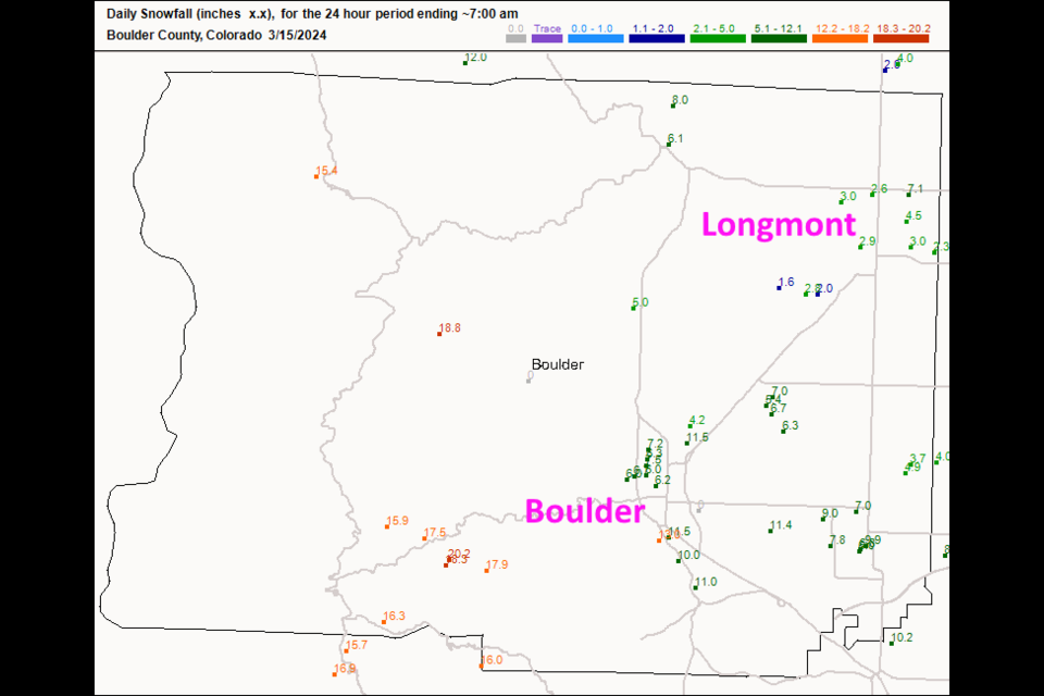
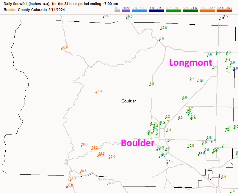
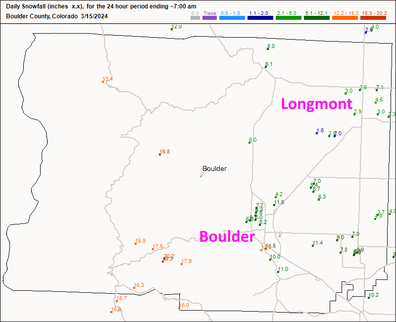
The storm delivered!  Longmont received over 2 inches of liquid and about 7-11 inches of snow in spots. Boulder saw 12-19 inches.

We warm up, melt off and dig out from here.

figure1u_03152024
Figure 1 update: the CoCoRaHS new snow report as of 7 am Thursday.
figure2u_03152024
Figure 2 update: the CoCoRaHS new snow report as of 7 am Friday.

End Friday update.

Forecast Discussion:

Winter Storm Warning

Issued: 8:13 PM Mar. 12, 2024 – National Weather Service

...WINTER STORM WARNING IN EFFECT FROM 9 PM WEDNESDAY TO 6 AM MDT FRIDAY...

* WHAT...Heavy snow expected. Total snow accumulations between 9 and 18 inches. Winds gusting as high as 35 mph.

* WHERE...Boulder and the western suburbs of Denver, and Denver.

* WHEN...From 9 PM Wednesday to 6 AM MDT Friday.

* IMPACTS...Travel could be very difficult to impossible. The hazardous conditions could impact the Wednesday evening and Thursday morning commutes.

PRECAUTIONARY/PREPAREDNESS ACTIONS...

If you must travel, keep an extra flashlight, food, and water in your vehicle in case of an emergency. The latest road conditions for

Colorado can be obtained by calling 5 1 1 or by going to www.cotrip.org.
________________________________________________________________________

We have the warmth before the storm. Finally, it looks like a major winter storm is on its way. It should be the biggest of the year (channel 9 said the biggest in 3 years). We might hear some thunder early Wednesday morning, with a break in the action Wednesday morning with rain chances picking up again in the afternoon. Any rain that falls should change over to snow around 8pm (but could wait as long as the pre-dawn hours).  If it does change to snow in the evening, then top snow totals are expected. (Figure 1)

It is looking more likely that most of I-25 south of Ft. Collins and especially the Denver Metro will get to or exceed a foot of snow. Snow tapers off early morning Friday.

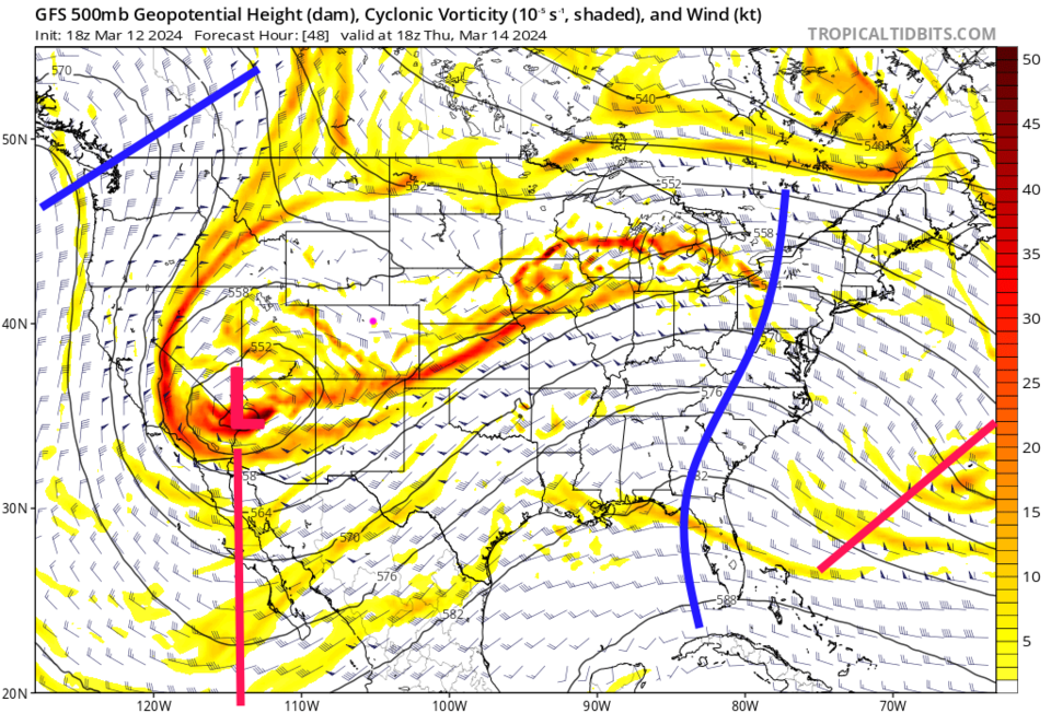
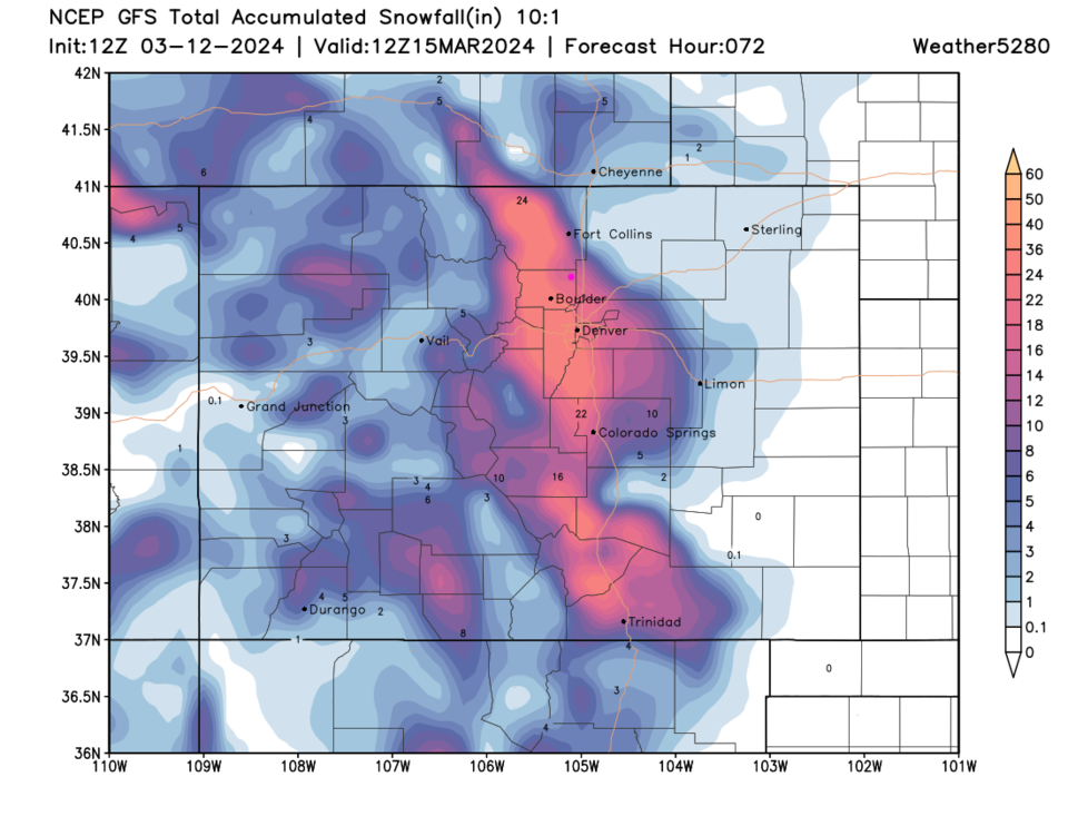
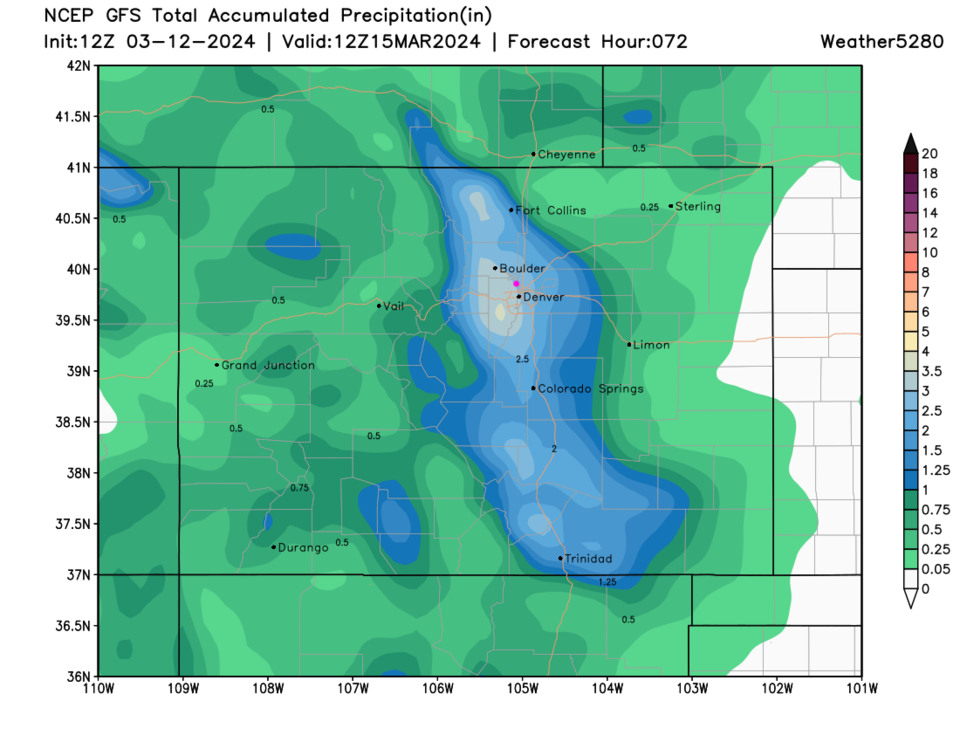
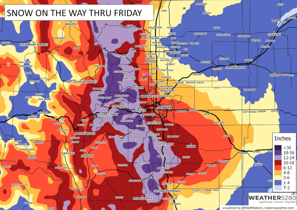
The system is powered by a slow moving cut-off low that will roll by (Figure 2). The central mountains might pick up areas of 32-46 inches of snow (Figure 3). The pre-snow rain isn't looking very impressive, currently - maybe 0.1-0.25" of water (Figure 4) at the lower elevations. Matt Makens's map from weather5280 12-24" for Boulder and 6-12" for western Denver (Figure 5).  Note: the trend in the models is for even more snow to fall forecast after forecast. I'll update as needed.

Snowfall roundup for Longmont:

Weather5280:   10.9"
The GFS:        14-16"
The NAM:       16-18"
The Canadian: 10-12"
Channel 9:       6-12"
Channel 7:        7"
My forecast:    7-14"


figure1_03122024
Figure 1: the 10 day graphical forecast for Longmont from weatherunderground.com
figure2_03122024
Figure 2: the 500mb upper air forecast map from the GFS and tropicaltidbits.com
figure3_03122024
Figure 3: the 3 day 10:1 snowfall forecast from the GFS and weather5280.com
figure4_03122024
Figure 4: the 3 day precipitation (and snow melt) forecast from the GFS and weather5280.com
figure5_03122024
Figure 5: the weather5280.com// Matt Makens snowfall forecast from this storm.

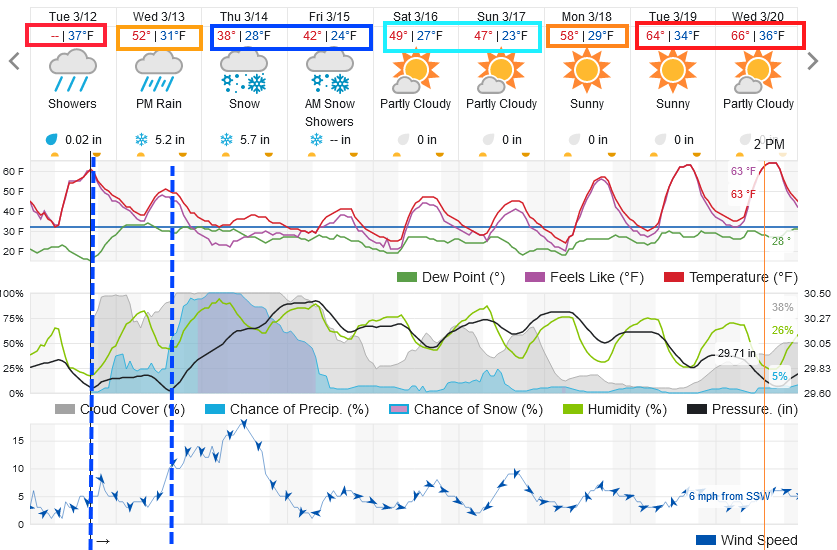
The Long Range Forecast:

For the weekend and beyond, we warm up and dig out.


About the Author: John Ensworth

John Ensworth used to work from Longmont as the PI for the NASA through the IGES (The Institute for Global Environmental Strategies). He now teaches technology, algebra, astronomy, meteorology, film school, and Lego robotics to middle/high school.
Read more


Comments


Current Weather

Cloudy

Cloudy

82°F

UV Index
0 Low
Pressure
30.06 Rising
Visibility
8 miles
Dewpoint
55 °F
Humidity
40%
Wind
ENE 4.4 mph
Gust
8.7 mph
Wind Chill
82 °F

Hourly Forecast

Today
8 PM
81°F
Thunderstorms
Today
9 PM
77°F
Mostly cloudy
Today
10 PM
73°F
Mostly clear
Today
11 PM
70°F
Partly cloudy w/ t-storms
Tomorrow
12 AM
69°F
Partly cloudy w/ t-storms
Tomorrow
1 AM
68°F
Mostly clear
Tomorrow
2 AM
66°F
Mostly clear
Tomorrow
3 AM
65°F
Mostly clear
Tomorrow
4 AM
64°F
Mostly clear
Tomorrow
5 AM
63°F
Mostly clear
Tomorrow
6 AM
62°F
Mostly sunny
Tomorrow
7 AM
63°F
Mostly sunny

7 Day Forecast

Partly sunny w/ t-storms

Friday

93 °F

Not as hot with times of clouds and sun; a couple of thunderstorms this afternoon


Partly cloudy w/ t-storms

Friday Night

62 °F

A thunderstorm in spots this evening; otherwise, mainly clear


Partly sunny w/ t-storms

Saturday

91 °F

Partly sunny with a thunderstorm in the afternoon


Partly cloudy w/ t-storms

Saturday Night

60 °F

A thundershower in spots in the evening; otherwise, mainly clear


Mostly sunny

Sunday

99 °F

Mostly sunny and very warm


Clear

Sunday Night

58 °F

Clear


Sunny

Monday

103 °F

Sunny and hot; caution advised if outside for extended periods of time


Clear

Monday Night

58 °F

Clear


Mostly sunny

Tuesday

103 °F

Mostly sunny and hot; heat will be dangerous, minimize outdoor activity


Mostly clear

Tuesday Night

60 °F

Mainly clear


Sunrise and Sunset

Sunrise
5:54 AM
Sunset
8:20 PM

Based on AccuWeather data