Skip to content
Join our Newsletter

The Front Range Forecast: Warm week, snow on the weekend

Figure3_02262022
Figure 3: the surface map for Saturday noon March 5th from tropicaltidbits.com and the GFS.

In Brief:

A very warm week becomes a fairly long stretch of unsettled weather and snow.

Forecast Discussion:

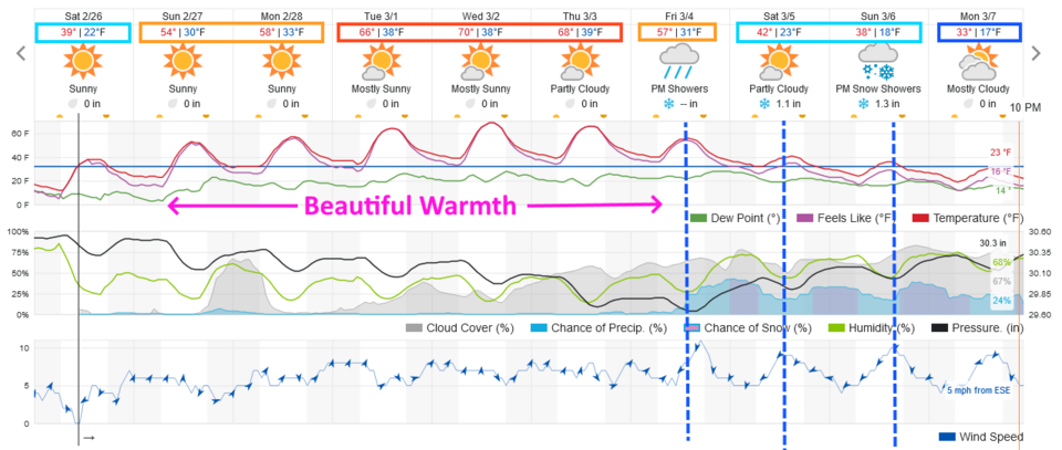
This week will be the week of a thaw (Figure 1).  Even the low temperatures, mid-week, will be 20 degrees warmer than the highs we had last week.  Incredible bounce!

Figure1_02262022
Figure 1: The 10 day graphical forecast for Denver from weatherunderground.com

The Longer Range Forecast:

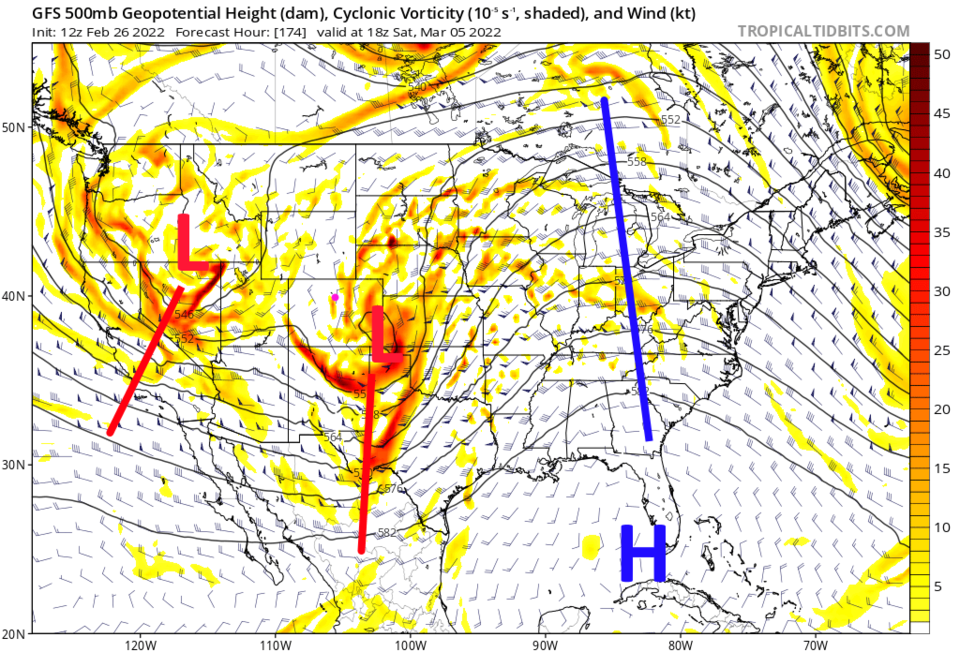
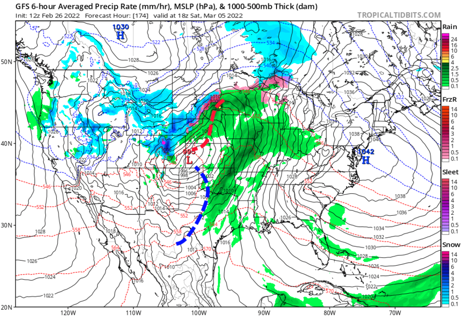
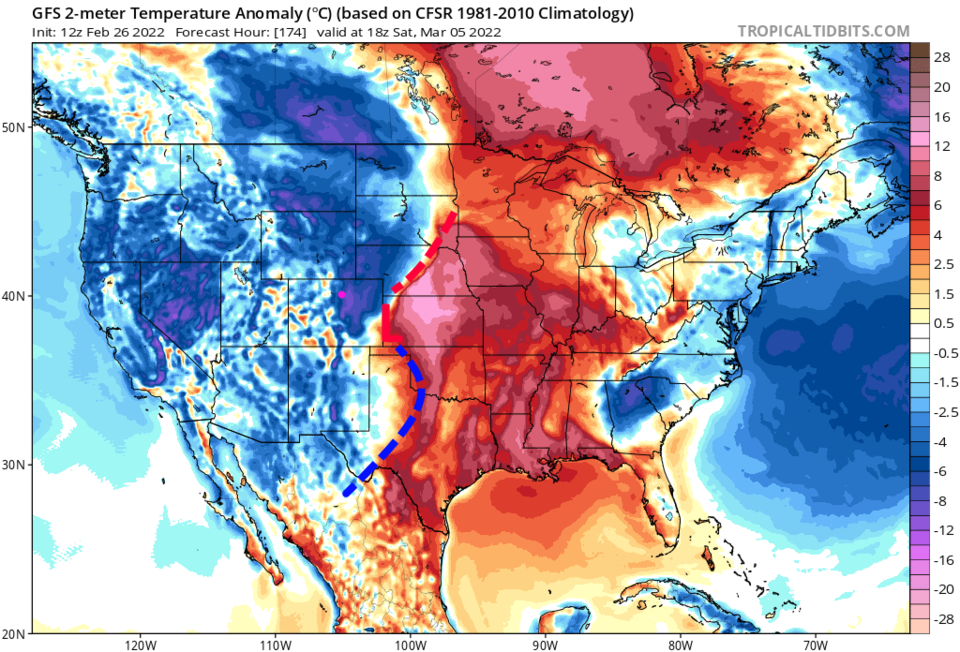
Our next change in the weather arrives with the first in a series of cold fronts that begins noon Friday. Each front will bring a pulse of precipitation (Figure 1 dashed blue lines). Those fronts will be associated with each lobe of lower heights sliding along with the jet stream (Figure 2). The first storm looks pretty healthy with heavy snow in spots (Figure 3). Note that there is rain at the southern and eastern edges of the precipitation.  Temperatures are not too cold over the weekend (Figure 4).  This period of snow will not feel like our last snow storm.

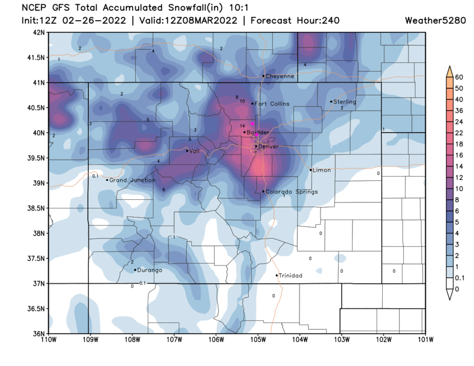
Over the next 10 days, areas just west of the interstate and around Denver seem to be slated for around a foot of snow.  Snowfall amounts vanish as one moves to the southeast due to the warmth of the system.  I'll keep and eye on it all week with updates as usual! Enjoy it out there!

Figure2_02262022
Figure 2: the 500mb upper air map for Saturday noon March 5th from tropicaltidbits.com and the GFS.
Figure3_02262022
Figure 3: the surface map for Saturday noon March 5th from tropicaltidbits.com and the GFS.
Figure4_02262022
Figure 4: the surface temperatures departure from normal map for Saturday noon March 5th from tropicaltidbits.com and the GFS.
Figure5_02262022
Figure 5: the 10 day snowfall totals from the GFS and weather5280.com


About the Author: John Ensworth

John Ensworth used to work from Longmont as the PI for the NASA through the IGES (The Institute for Global Environmental Strategies). He now teaches technology, algebra, astronomy, meteorology, film school, and Lego robotics to middle/high school.
Read more


Comments


Current Weather

Sunny

Sunny

74°F

UV Index
9 Very High
Pressure
30.36 Steady
Visibility
8 miles
Dewpoint
42 °F
Humidity
32%
Wind
ESE 1.7 mph
Gust
4.8 mph
Wind Chill
74 °F

Hourly Forecast

Today
12 PM
75°F
Sunny
Today
1 PM
77°F
Sunny
Today
2 PM
78°F
Sunny
Today
3 PM
79°F
Mostly sunny
Today
4 PM
80°F
Mostly sunny
Today
5 PM
79°F
Partly sunny
Today
6 PM
77°F
Partly sunny
Today
7 PM
75°F
Partly sunny
Today
8 PM
70°F
Mostly sunny
Today
9 PM
66°F
Mostly clear
Today
10 PM
62°F
Mostly clear
Today
11 PM
57°F
Mostly clear

7 Day Forecast

Mostly sunny

Saturday

80 °F

Mostly sunny; dry weather continues; have your sunglasses and/or hat handy


Mostly clear

Saturday Night

46 °F

Clear to partly cloudy


Partly sunny

Sunday

84 °F

Very warm with sunshine mixing with some clouds; windy in the afternoon


Partly cloudy

Sunday Night

50 °F

Partly cloudy


Partly sunny

Monday

87 °F

Partly sunny and very warm with the temperature approaching the record of 91 set in 1962


Clear

Monday Night

52 °F

Clear


Partly sunny

Tuesday

87 °F

Remaining very warm with partial sunshine; breezy in the afternoon


Clear

Tuesday Night

53 °F

Clear


Mostly cloudy

Wednesday

67 °F

Cooler with sun followed by clouds; breezy in the afternoon


Mostly cloudy

Wednesday Night

47 °F

Considerable cloudiness


Sunrise and Sunset

Sunrise
5:50 AM
Sunset
8:04 PM

Based on AccuWeather data