Skip to content

The Front Range Forecast: Warm weekend, fridged with snow all week

In Brief:

This warm beautiful weekend will be replaced by extreme cold and prolonged snow.

Forecast Discussion:

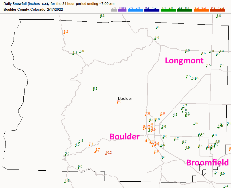
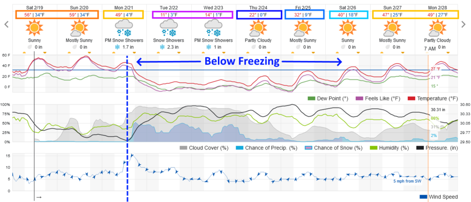
Before we look ahead to the next snow storm, we need to check on what fell on Wednesday.  Longmont saw about 2.5-5 inches.  Broomfield saw about 4-6 inches (Figure 1).  We will warm this weekend to nearly 60F.  Rapid melting should help clear roads and sidewalks in advance of our next snow (Figure 2).

Figure1_02092022
Figure 1: the CoCoRaHS snowfall reports as of Thursday AM.
Figure2_02092022
Figure 2: the 10 day graphical forecast from weatherunderground.com for Denver, CO.

The Longer Range Forecast:

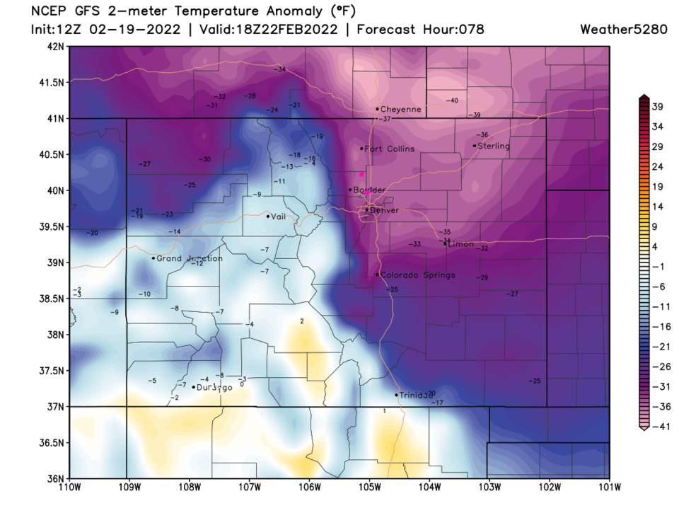
Still looking at Figure 2- once the front hits around 2 p.m. Monday, the bottom drops out on temperatures. Figure 3 is a map of temperature departure from normal Tuesday noon.  Areas around I-25 are 30-35 degrees below normal with areas around Cheyenne getting to 40 degrees colder than normal. I would not be surprised if the high on Tuesday doesn't break 10F. 

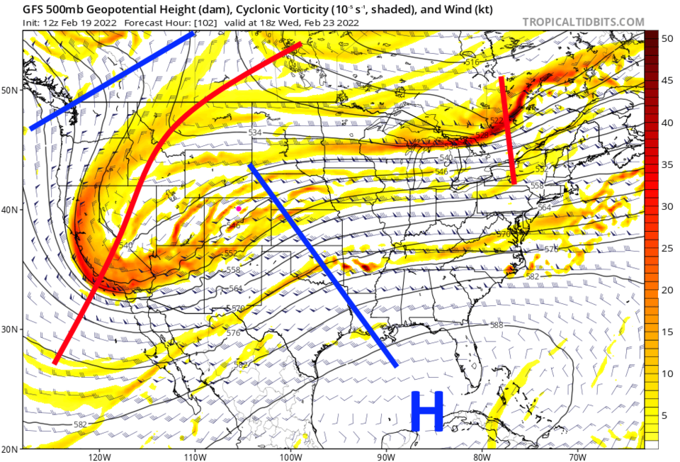
This system will also be slow to cross the state.  It looks like almost three days of snow showers are on the way. That is because of the size of the trough that is moving in (Figure 4). The smaller (or shorter) the trough is in the upper atmosphere, the quicker it moves, the larger, the slower.  This is a pretty big wave this time.

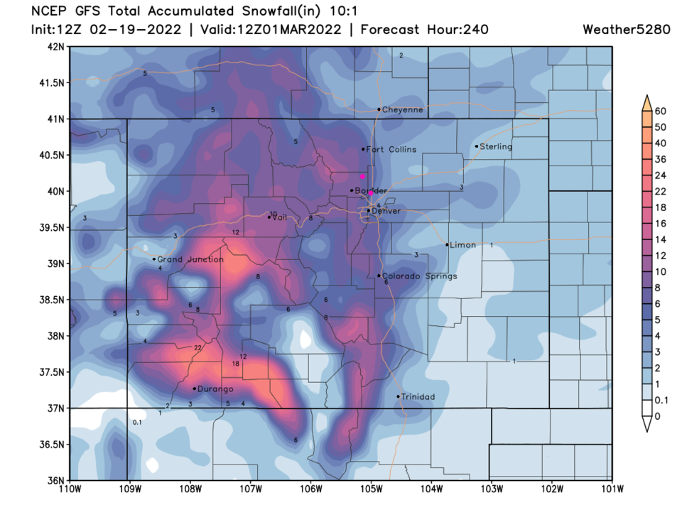
It is too early for accurate snow totals, but 5-8 inches over three days is what you should start to plan for.  More later and find your biggest coat!

Figure3_02092022
Figure 3: the temperature anomaly (departure from normal) for Tuesday noon from tropicaltidbits.com
Figure4_02092022
Figure 4: the 500mb upper air forecast map for Wednesday noon from the GFS and tropicaltidbits.com
Figure5_02092022
Figure 5: the 10 day (10:1 ratio) total snowfall forecast from the GFS and weather5280.com


About the Author: John Ensworth

John Ensworth used to work from Longmont as the PI for the NASA through the IGES (The Institute for Global Environmental Strategies). He now teaches technology, algebra, astronomy, meteorology, film school, and Lego robotics to middle/high school.
Read more


Comments


Current Weather

Sunny

Sunny

57°F

UV Index
5 Moderate
Pressure
30.09 Rising
Visibility
8 miles
Dewpoint
42 °F
Humidity
57%
Wind
E 3.3 mph
Gust
6.5 mph
Wind Chill
57 °F

Hourly Forecast

Today
10 AM
62°F
Mostly sunny
Today
11 AM
66°F
Mostly sunny
Today
12 PM
69°F
Mostly sunny
Today
1 PM
72°F
Mostly sunny
Today
2 PM
75°F
Mostly sunny
Today
3 PM
78°F
Mostly sunny
Today
4 PM
76°F
Partly sunny w/ t-storms
Today
5 PM
73°F
Mostly sunny
Today
6 PM
71°F
Mostly sunny
Today
7 PM
68°F
Mostly sunny
Today
8 PM
65°F
Partly sunny
Today
9 PM
63°F
Partly cloudy

7 Day Forecast

Partly sunny w/ t-storms

Saturday

78 °F

Mostly sunny and not as warm, becoming breezy with a thunderstorm in spots this afternoon


Partly cloudy

Saturday Night

49 °F

Partly cloudy


Mostly sunny

Sunday

84 °F

Sunshine and patchy clouds; breezy in the afternoon


Mostly clear

Sunday Night

49 °F

Mainly clear


Intermittent clouds

Monday

70 °F

Cooler with times of sun and clouds; a thunderstorm in spots in the afternoon


Thunderstorms

Monday Night

46 °F

Cloudy with a couple of thundershowers


Thunderstorms

Tuesday

60 °F

Mostly cloudy and cooler; a couple of afternoon showers and a thunderstorm


Intermittent clouds

Tuesday Night

37 °F

Partly cloudy


Partly sunny

Wednesday

73 °F

Pleasant and warmer with partial sunshine


Mostly clear

Wednesday Night

40 °F

Mainly clear


Sunrise and Sunset

Sunrise
5:41 AM
Sunset
8:13 PM

Based on AccuWeather data