The Video Forecast for this Week
In Brief:
Steady warming with afternoon winds + fire danger.
Wednesday Update:
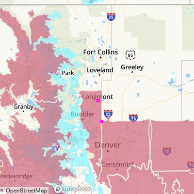
As temperatures warm, winds remain. The NWS has a new Red Flag Warning for the areas shaded in red (Figure 1 update):
Red Flag Warning
Issued: 2:14 PM Apr. 13, 2022 – National Weather Service
...RED FLAG WARNING IN EFFECT FROM 11 AM TO 7 PM MDT THURSDAY FOR WIND AND LOW RELATIVE HUMIDITY FOR PORTIONS OF THE PLAINS FROM BOULDER AND DENVER EASTWARD THROUGH EAST CENTRAL COLORADO...
The National Weather Service in Denver has issued a Red Flag Warning for wind and low relative humidity, which is in effect from 11 AM to 7 PM MDT Thursday.
* Timing...Late morning through early evening Thursday.
* Winds...West 15 to 25 mph with gusts up to 45 mph.
* Relative Humidity...As low as 14 percent.
* Impacts...Any fire that develops will have the potential to spread rapidly. Outdoor burning should be avoided, as well as any activity that may produce a spark and start a fast moving wildfire.
PRECAUTIONARY/PREPAREDNESS ACTIONS...
A Red Flag Warning means that critical fire weather conditions are either occurring now....or will shortly. A combination of strong winds...low relative humidity...and warm temperatures can contribute to extreme fire behavior.
_____________________________________________________________________________
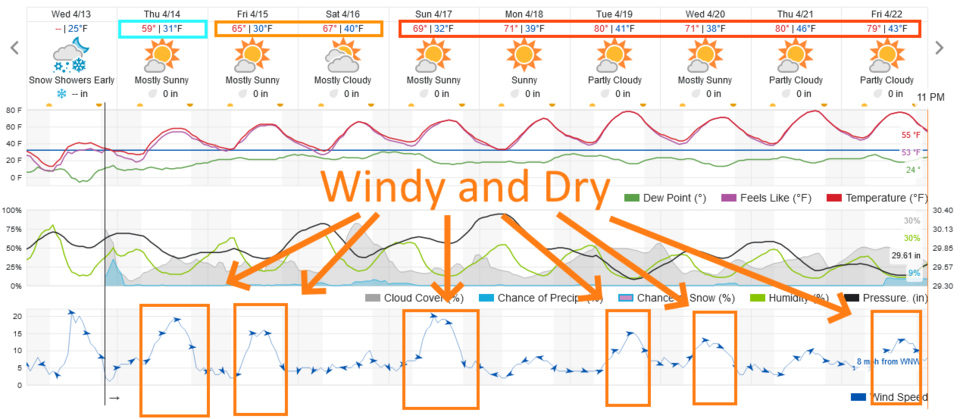
It looks like we warm to around 70 on the weekend (Figure 2 update) then near 80 next week. No really precipitation is likely for the next 7-10 days (there IS a small chance of something 'interesting' around Tuesday/Wednesday next week.

End Wednesday update.
Forecast Discussion:
We'll start with the NWS issued Red Flag Warnings for Saturday and Sunday:
Red Flag Warning:
Issued: 4:44 AM Apr. 9, 2022 – National Weather Service
...RED FLAG WARNING REMAINS IN EFFECT FROM 11 AM THIS MORNING TO 7 PM MDT THIS EVENING FOR WIND AND LOW RELATIVE HUMIDITY FOR THE I-25 CORRIDOR AND PORTIONS OF THE PLAINS...
...FIRE WEATHER WATCH IN EFFECT FROM SUNDAY MORNING THROUGH SUNDAY EVENING FOR WIND AND LOW RELATIVE HUMIDITY FOR THE
I-25 CORRIDOR AND PORTIONS OF THE PLAINS...
The National Weather Service in Denver has issued a Fire Weather Watch for wind and low relative humidity, which is in effect from Sunday morning through Sunday evening.
* Timing...11 AM MDT until 7 PM MDT today and Sunday.
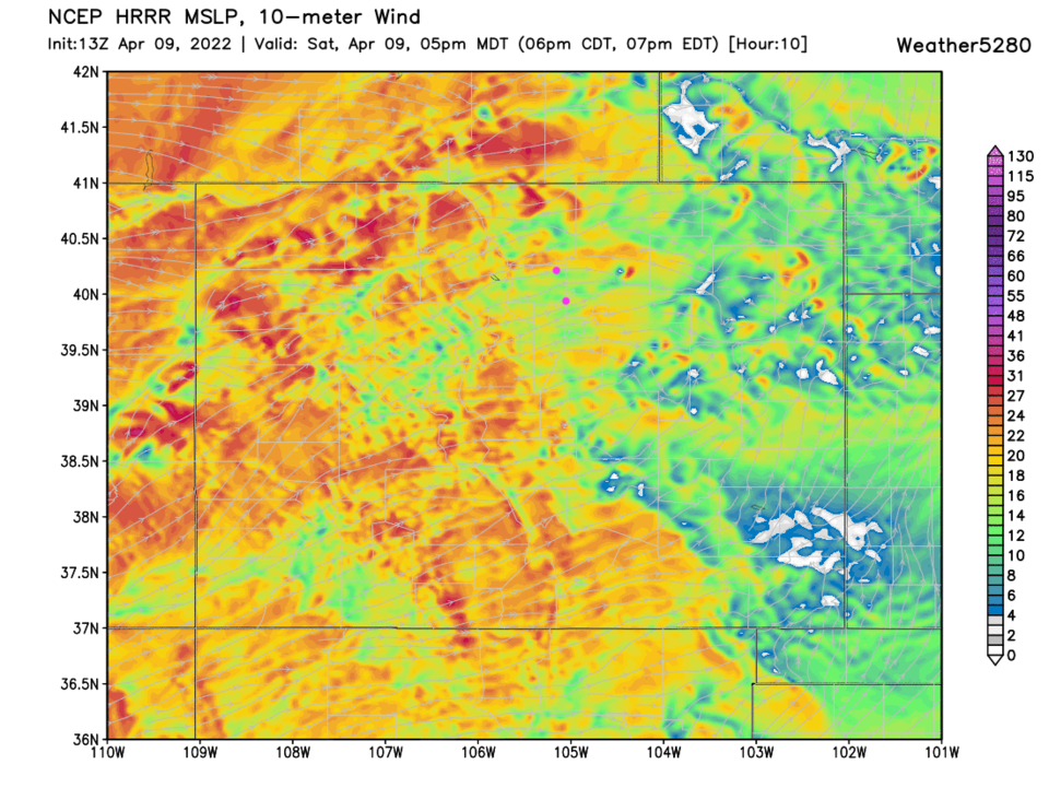
* Winds...West 10 to 20 mph with gusts to 30 mph today. Northwest 20 to 30 mph with gusts up to 45 mph on Sunday. (See Figure 1).
* Relative Humidity...As low as 11 percent.
* Impacts...Any fire that develops will likely spread rapidly. Outdoor burning should be avoided, as well as any activity that may produce a spark and start a fast moving wildfire.
PRECAUTIONARY/PREPAREDNESS ACTIONS...
A Red Flag Warning means that critical fire weather conditions are either occurring now....or will shortly. A combination of strong winds...low relative humidity...and warm temperatures can contribute to extreme fire behavior. A Fire Weather Watch means that critical fire weather conditions
are forecast to occur. Listen for later forecasts and possible Red Flag Warnings.
______________________________________
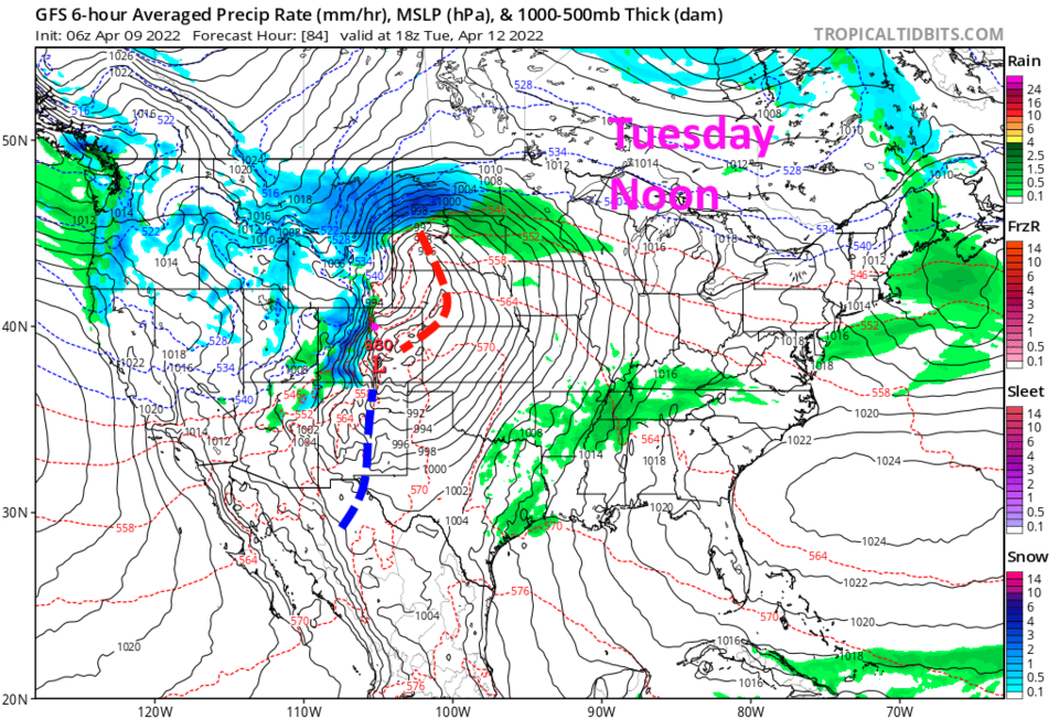
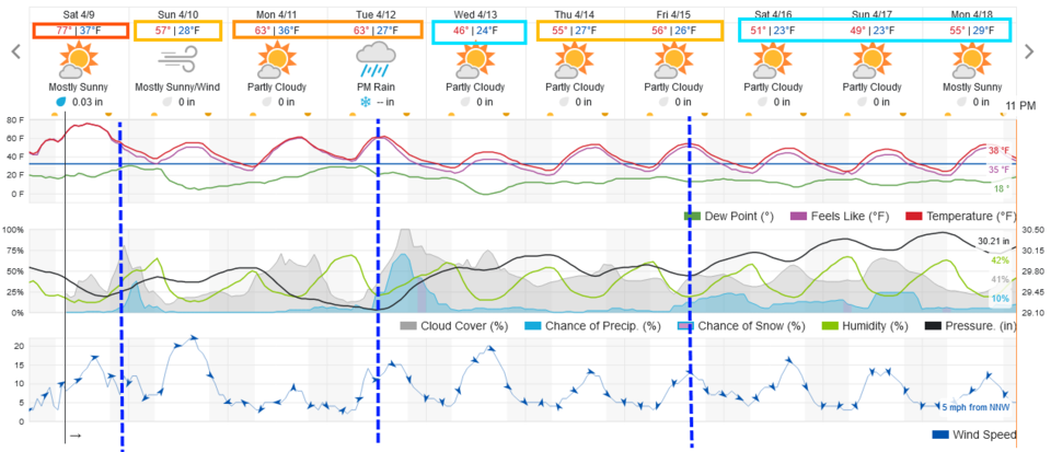
Our first of three fronts arrives around midnight Saturday into Sunday. This will cool us about 20 degrees and kick up a few showers, a bit of mountain snow, and bring more wind (Figure 1 and 2). The chance of rain along I-25 and snow in the mountains is pretty small and short lived (Figure 3). We warm to the 60's for the start of the week.
The Longer Range Forecast:
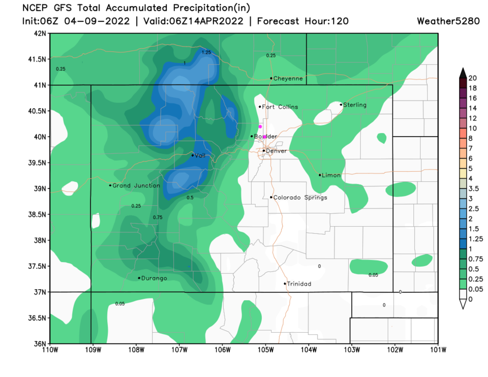
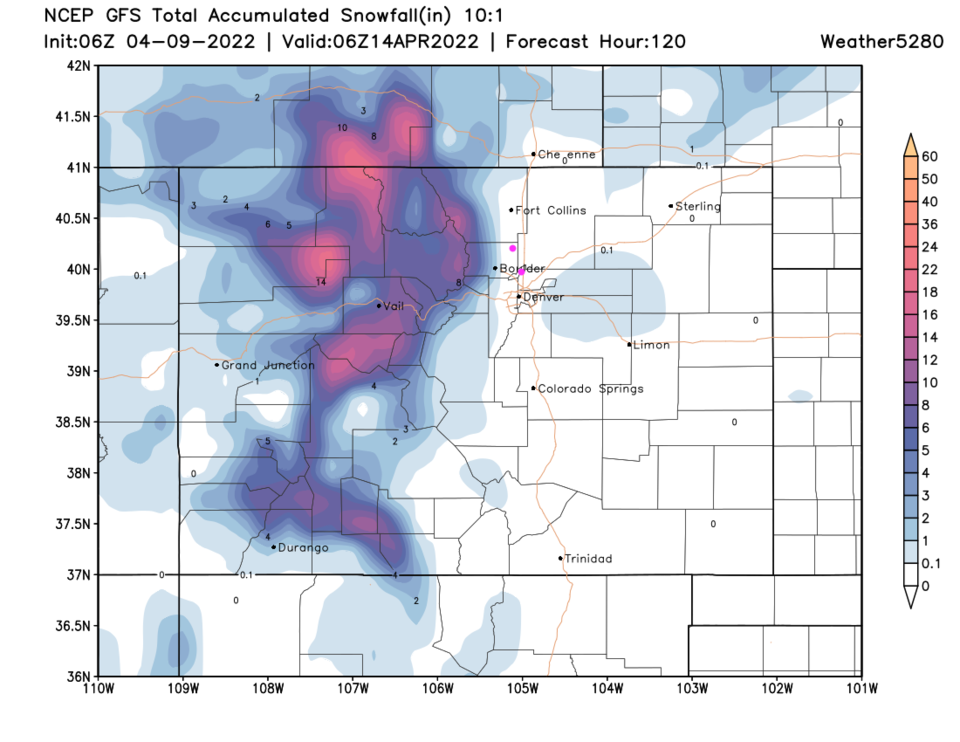
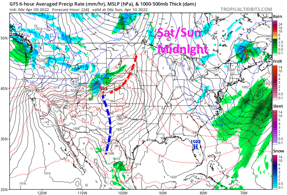
Our next front arrives around noon on Tuesday (Figure 2). This front will drop temperatures about 15 degrees and bring a better chance of rain to the lower elevations and snow to the mountains (Figure 4). The GFS still doesn't give the I-25 corridor much rain, but drops 1-2 inches of water to the northern mountains (Figure 5). Other models are a bit 'wetter.' The good snow totals only accumulate at the higher elevations of the central and northern mountains (Figure 6). Spring is getting underway in 'fits and starts.'