Skip to content

The Next Storm/Next Snow Forecast Discussion from the Cherrywood Observatory – April 13, 2018

This content was originally published by the Longmont Observer and is licensed under a Creative Commons license.

Forecast Discussion:

Since this storm is rolling in Thursday PM - I'm posting the Friday discussion a 1/2 day early to cover this front. AND there is a chance of snow is now possible!! (Don't get the shovels or sleds out though.)

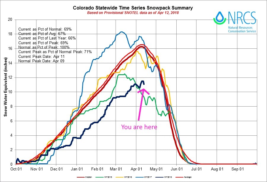
But first, where are we with the snowpack (this has been out on twitter today)?  Figure 1 is the snowpack in dark blue (with the 'you are here' arrow) for Colorado overall.  We are above where we were in 2015 (green line) but below normal stukk. Our last storm (with the prolonged moist westerly flow) was helpful!

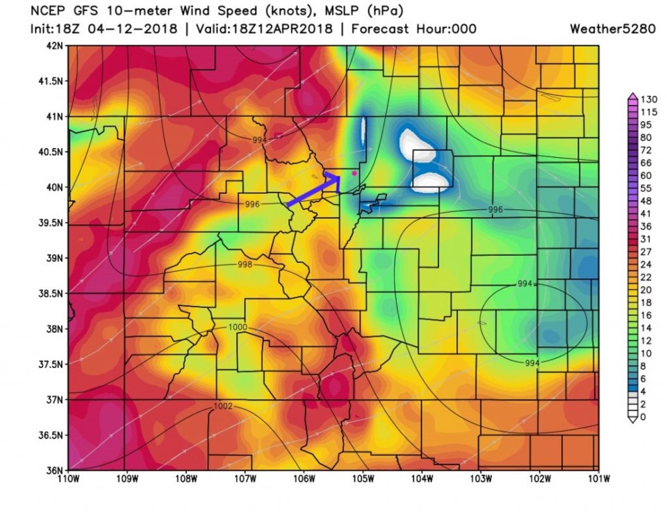
The winds in Longmont were delayed until later in the afternoon.  The high wind warning and fire danger were expected to expire at 9pm Thursday. Figure 1 shows those mountain and foothill winds and the blue arrow gives direction (also seen in the thin grey lines with arrows on them; streamlines).

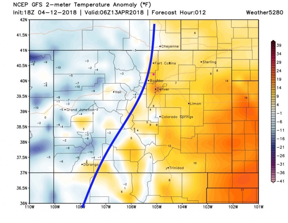
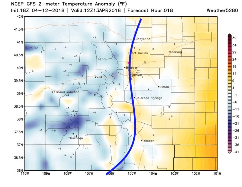
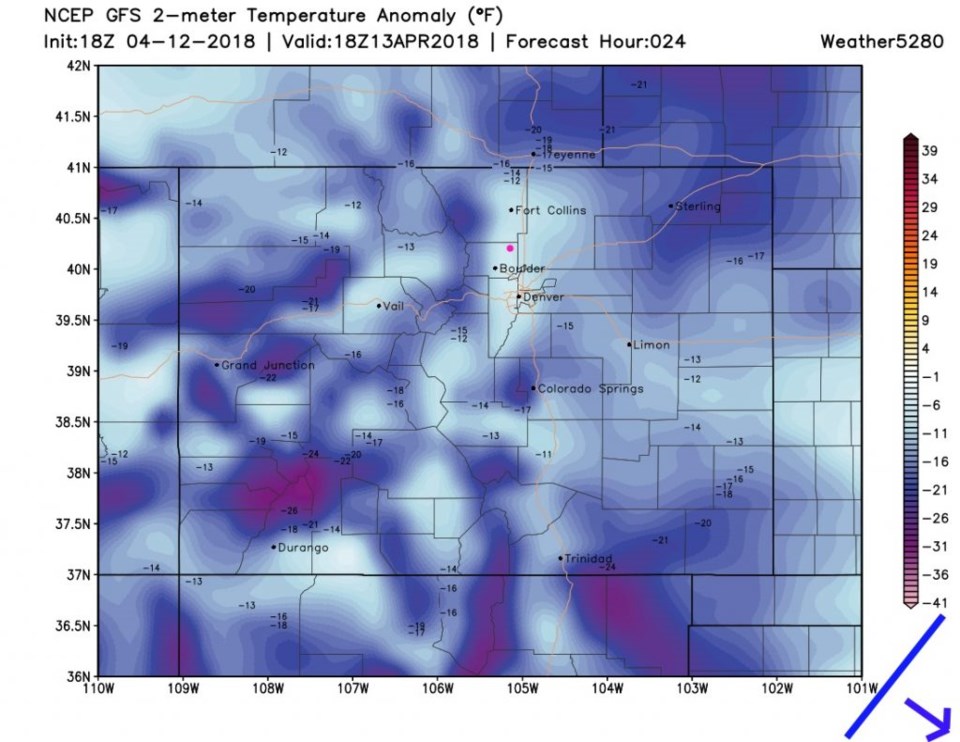
Figure 2 shows the temperature anomaly map with an approximate location of the front midnight Thursday. Figure 3 has the front past us (and might actually be almost to Kansas in reality). Temperatures are dropping Friday by sunrise.  By noon today (Friday)- much colder air is in place- state wide (the front is way off to the east and southeast) - Figure 5.

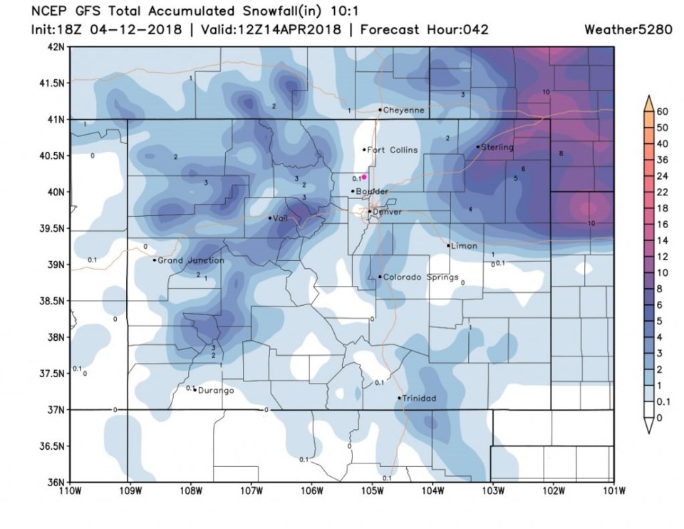
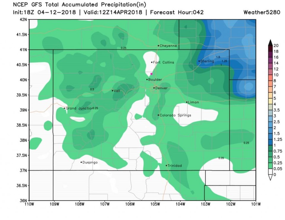
The good news is that, even though down slow flow will keep us pretty dry, enough lift and moisture should move in that we now get a coating to an inch of snow (Figure 6).  But it is not a lot of water (Figure 7) 0.05-0.25 inches - with the low end most likely.  You can see the good snow storm (with the wind--> blizzard conditions will be possible) way out near Nebraska in NE CO.

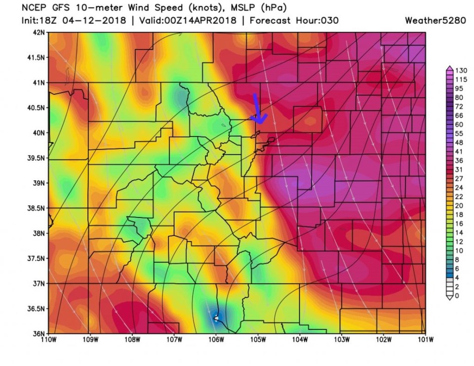
Figure 8 are the midday Friday winds, like Figure 2, and the powerful (sustained 25-30mph gusts to 50mph) north winds are still on tap for Longmont.  A wide area of the plains sits with 55mph sustained winds midday today (Friday).

Figure 1: the current snowfall (dark blue line) is compared to the average (bright red line) of the last 4 years. The prior 4 years are red, green, yellow and light blue) from, NRCS and SNOTEL.

Figure 2: GFS forecast surface pressure (black lines), streamlines (grey lines with arrows) and wind speeds (color gradients) for noon Thursday (yes, yesterday). From weather5280.com.

Figure 3: the GFS forecast surface temperature anomaly (departure from normal) for Friday PM. The blue line is an approximate location for the incoming front/wind shift direction. Longmont is the pink dot. From weather5280.com.

Figure 4: the GFS forecast surface temperature anomaly (departure from normal) for Friday AM. The blue line is an approximate location for the incoming front/wind shift direction. Longmont is the pink dot. From weather5280.com.

Figure 5: the GFS forecast surface temperature anomaly (departure from normal) for Friday noon. The blue line is an approximate location for the incoming front/wind shift direction. Longmont is the pink dot. From weather5280.com.

Figure 6: the GFS forecast total snowfall estimate from Thur PM to Saturday AM From weather5280.com.

Figure 7: the GFS forecast total precipitation estimate from Thur PM to Saturday AM From weather5280.com.

Figure 8: GFS forecast surface pressure (black lines), streamlines (grey lines with arrows) and wind speeds (color gradients) for Friday PM. From weather5280.com.

The longer range forecast:

We warm rapidly to almost 80F again on Monday.  Our next chance of rain is Friday/Saturday at the end of the upcoming week.  More on that later!

Current Weather

Clear

Clear

45°F

UV Index
0 Low
Pressure
29.87 Falling
Visibility
8 miles
Dewpoint
36 °F
Humidity
69%
Wind
NW 2.3 mph
Gust
6.4 mph
Wind Chill
45 °F

Hourly Forecast

Today
3 AM
43°F
Mostly clear
Today
4 AM
42°F
Mostly clear
Today
5 AM
40°F
Mostly clear
Today
6 AM
39°F
Mostly sunny
Today
7 AM
42°F
Mostly sunny
Today
8 AM
47°F
Partly sunny
Today
9 AM
52°F
Partly sunny
Today
10 AM
57°F
Intermittent clouds
Today
11 AM
62°F
Mostly cloudy
Today
12 PM
65°F
Cloudy
Today
1 PM
69°F
Cloudy
Today
2 PM
73°F
Cloudy

7 Day Forecast

Intermittent clouds

Saturday

64 °F

Cooler with clouds giving way to some sun


Mostly clear

Saturday Night

39 °F

Clear to partly cloudy


Mostly cloudy

Sunday

77 °F

Rather cloudy and warmer; breezy this afternoon


Mostly cloudy

Sunday Night

48 °F

Cloudy most of the time


Windy

Monday

57 °F

Winds gusting past 40 mph; cloudy and cooler


Intermittent clouds

Monday Night

43 °F

Partly cloudy


Intermittent clouds

Tuesday

59 °F

Windy and cool with times of clouds and sun


Partly cloudy

Tuesday Night

32 °F

Partly cloudy


Intermittent clouds

Wednesday

60 °F

Times of clouds and sun


Intermittent clouds

Wednesday Night

35 °F

Partly cloudy


Sunrise and Sunset

Sunrise
5:55 AM
Sunset
7:59 PM

Based on AccuWeather data