Skip to content

The Next Storm/Next Snow Forecast Discussion from the Cherrywood Observatory – April 15, 2018

This content was originally published by the Longmont Observer and is licensed under a Creative Commons license.

Forecast Discussion:

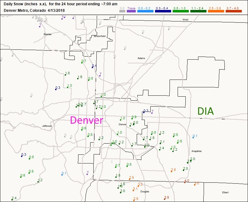
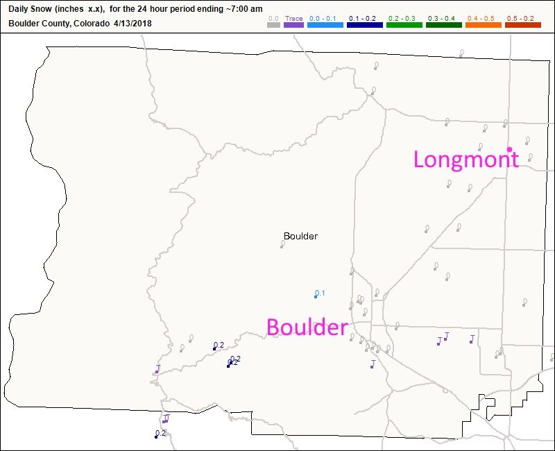
Our last storm came in a couple of waves.  Thursday into Friday, Denver saw some significant snow (Figure 1) ranging from just a trace in the northern reaches to over 3 inches in the south (up slope flow on to the Palmer Divide).  At the same time, Boulder county received almost nothing (Figure 2).  Larmier county only registered a trace in a couple of stations (no figure, too boring).

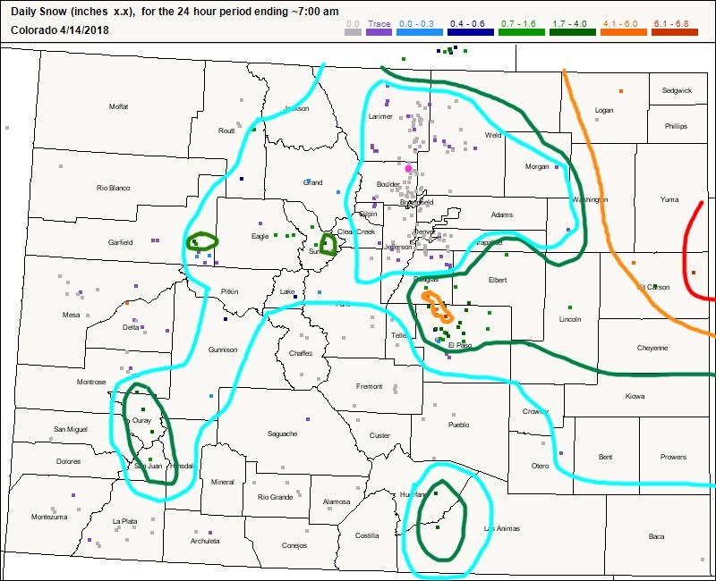
Friday into Saturday, the blizzard cranked up out on far northeastern Plains.  I did a quick-and-dirty analysis of the snowfall depth and places out there there saw 4-7 inches of snow (Figure 3). Winds were very strong as well (hence the blizzard). Trees were felled across Limon, for example, with 70+mph wind gusts.

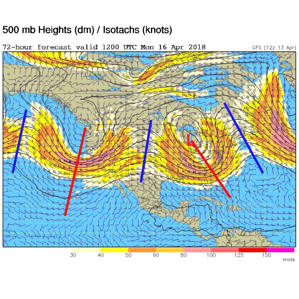
The low departs and a ridge approaches (Figure 4) warming us up this weekend and allowing winds to die down. We approach 80F again on Monday with the ridge of Figure 4 overhead.

Figure 1: The CoCoRaHS snowfall 24 hour snowfall reports up to 7am Friday for the Denver Metro.

Figure 2: The CoCoRaHS snowfall 24 hour snowfall reports up to 7am Friday for Boulder County.

Figure 3: The CoCoRaHS snowfall 24 hour snowfall reports up to 7am Saturday for Colorado. Sloppy rough contours added for a big picture glance.

Figure 4: The 500mb forecast map from the GFS for Monday AM. Longmont is the pink dot, red lines are troughs, blue lines are ridges.

The longer range forecast:

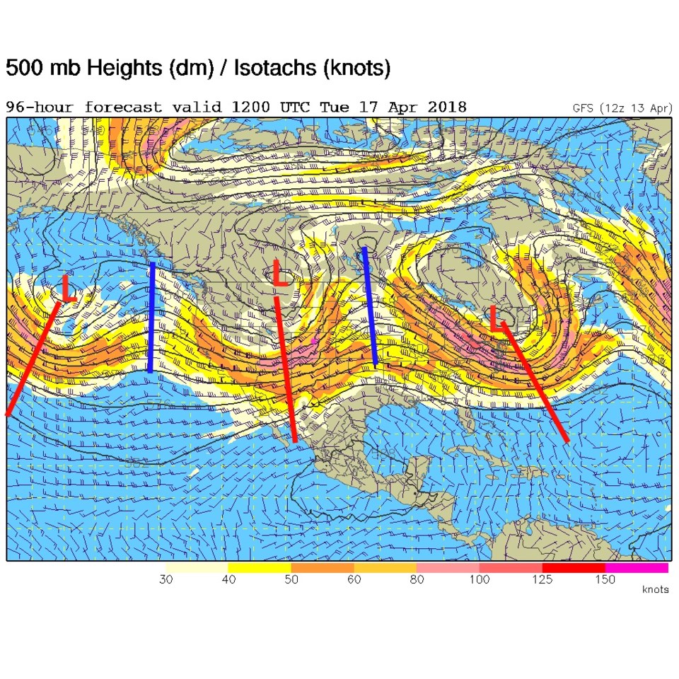
Right on the heels of this ridge is a trough that will blow through on Tuesday dropping temperatures briefly and giving us another windy day (Figure 5).  It is too early to know if there will be an elevated fire danger (but one must be careful with conditions as they are).

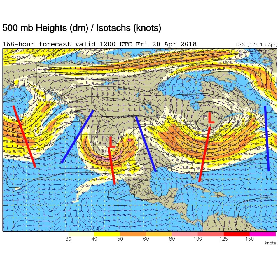
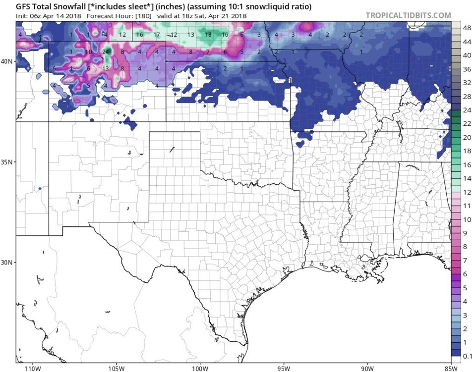
Our next big storm moves in on Friday into the weekend (Figure 6). The low height center digs much further south than the low height centers of the storms in Figure 4 and 5.  It should move through slower and create more instability over the state. As a hint of what might be coming, the 8 day GFS total snowfall map up through next Saturday paints Longmont with 8" of snow and puts a foot to two feet of snow up in the nearby mountains and across southern Wyoming and to the east (Figure 7).  We will have to watch this all week to see if it holds in, or fizzles out of, the forecast.

Figure 5: The 500mb forecast map from the GFS for Tuesday AM. Longmont is the pink dot, red lines are troughs, blue lines are ridges.

Figure 6: The 500mb forecast map from the GFS for Friday AM. Longmont is the pink dot, red lines are troughs, blue lines are ridges.

Figure 7: The GFS total snowfall between Saturday AM and next Saturday AM from tropicaltidbits.com

Current Weather

Cloudy

Cloudy

41°F

UV Index
1 Low
Pressure
29.96 Steady
Visibility
8 miles
Dewpoint
39 °F
Humidity
92%
Wind
W 1.7 mph
Gust
2.8 mph
Wind Chill
41 °F

Hourly Forecast

Today
10 AM
47°F
Mostly cloudy
Today
11 AM
51°F
Mostly cloudy
Today
12 PM
53°F
Cloudy
Today
1 PM
56°F
Thunderstorms
Today
2 PM
58°F
Cloudy
Today
3 PM
59°F
Thunderstorms
Today
4 PM
60°F
Mostly cloudy
Today
5 PM
62°F
Mostly cloudy
Today
6 PM
60°F
Mostly cloudy
Today
7 PM
58°F
Intermittent clouds
Today
8 PM
55°F
Intermittent clouds
Today
9 PM
52°F
Intermittent clouds

7 Day Forecast

Thunderstorms

Sunday

62 °F

Mostly cloudy and warmer with a thundershower in spots


Intermittent clouds

Sunday Night

38 °F

Partly cloudy


Partly sunny

Monday

70 °F

Partly sunny, pleasant and warmer


Intermittent clouds

Monday Night

44 °F

Partly cloudy


Mostly sunny

Tuesday

73 °F

Mostly sunny and pleasant


Intermittent clouds

Tuesday Night

41 °F

Clearing


Intermittent clouds

Wednesday

65 °F

Times of sun and clouds


Intermittent clouds

Wednesday Night

39 °F

A thundershower in spots in the evening; otherwise, partly cloudy


Rain

Thursday

56 °F

Cooler with occasional rain and drizzle; breezy in the morning


Partly cloudy

Thursday Night

32 °F

Partly cloudy


Sunrise and Sunset

Sunrise
6:03 AM
Sunset
7:53 PM

Based on AccuWeather data