Skip to content

The Next Storm/Next Snow Forecast Discussion from the Cherrywood Observatory – April 18, 2018

This content was originally published by the Longmont Observer and is licensed under a Creative Commons license.

Forecast Discussion:

As I write this, powerful wind gusts are making things thud and band around my house.  Figure 1 is a snapshot of the winds reported at 5pm across Colorado. Broomfield has 69mph winds blowing while Longmont is near 50mph.  The high wind warning and fire danger warning expired at 9pm Tuesday PM.

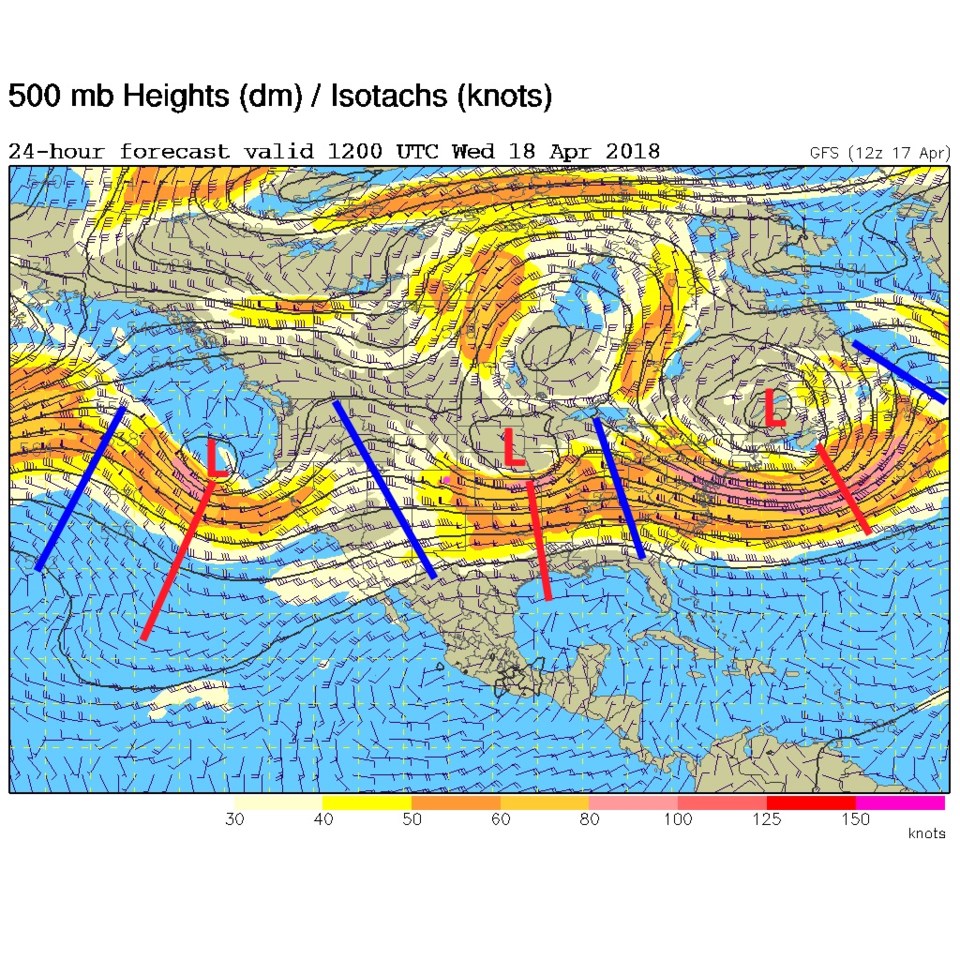
Figure 2-4 shows the dance of short wave troughs that will bring in our big storm for Friday and Saturday.  Figure 2, this morning (Wednesday) has the next ridge moving in.  We get calm, warm, and have mostly clear skies for a couple of days.

Figure 1: A snapshot of winds about 4pm from air sports net weather from Tuesday.

Figure 2: The GFS forecast upper air 500mb map for Wednesday AM. Ridges are blue lines, troughs are red lines. Low height centers are red L's.

The longer range forecast:

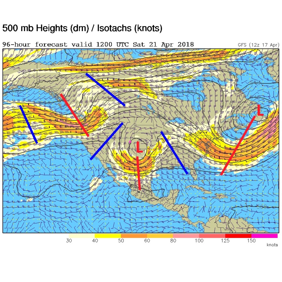
Figure 3, Friday AM, shows the upper level low pretty far south, close to the four corners area, but a touch north of where it was in prior discussion. This is good for up slope flow, but a dry slot might work its way up the Front Range if we are not careful. Figure 4, for Saturday AM, has the low a bit more spread out, less intense and maybe a touch too far north for the maximum precipitation amounts in Longmont.  It also means warmer temperatures and less snow chances down along I-25.

Figure 5 is an animation of the surface pressures and precipitation from the GFS from Thursday PM to Saturday PM. If you watch closely, you'll notice the low move across the northern AZ counties, then hop way up into Utah and northeast Colorado before plunging south.  This will limit cold air and some of the moisture we might otherwise receive.  We want the surface low to hug the CO/NM border and crawl slowly along.

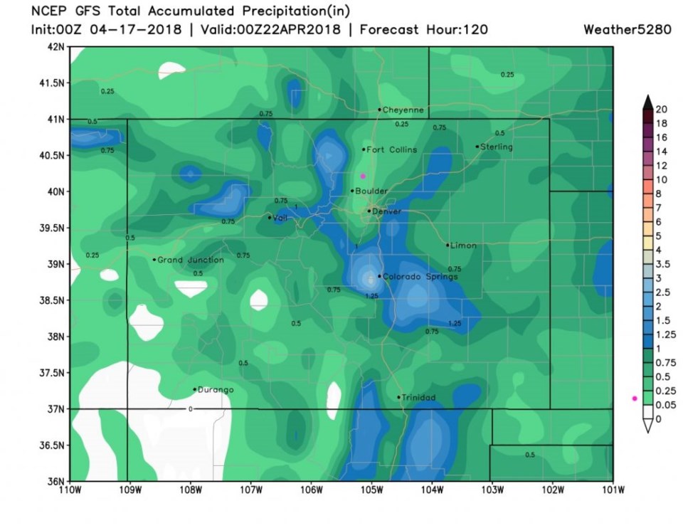
Our future snow totals still show Longmont in the coating or less snow amounts.  The mountains don't get as much widespread foot+ totals either (Figure 6).  Figure 7 is the water itself and while there is still a bullseye west of Colorado Springs, we have a down slope or dry slot looking area from Denver north to Ft. Collins.  This looks like a 1/10th to 1/4th an inch of water now for our fair city.  Oh come on, give us a 2 inch rain for once!

Figure 3: The GFS forecast upper air 500mb map for Friday AM. Ridges are blue lines, troughs are red lines. Low height centers are red L's.

Figure 4: The GFS forecast upper air 500mb map for Saturday AM. Ridges are blue lines, troughs are red lines. Low height centers are red L's.

Figure 5: An animated gif from the GFS and weather5280.com from Thursday PM to Saturday PM showing the low center jump north before traveling south into Texas. Precipitation type and intensity is also shown.

Figure 6: The total snowfall forecast from the GFS and weather5280.com between Tuesday PM and Saturday PM. Longmont is the pink dot.

Figure 6: The total precipitation forecast from the GFS and weather5280.com between Tuesday PM and Saturday PM. Longmont is the pink dot.

Current Weather

Partly cloudy

Partly cloudy

44°F

UV Index
0 Low
Pressure
29.96 Steady
Visibility
8 miles
Dewpoint
39 °F
Humidity
85%
Wind
WSW 1.7 mph
Gust
3.2 mph
Wind Chill
44 °F

Hourly Forecast

Today
2 AM
42°F
Partly cloudy
Today
3 AM
41°F
Partly cloudy
Today
4 AM
39°F
Partly cloudy
Today
5 AM
38°F
Partly cloudy
Today
6 AM
37°F
Partly cloudy
Today
7 AM
40°F
Partly sunny
Today
8 AM
45°F
Mostly sunny
Today
9 AM
50°F
Mostly sunny
Today
10 AM
56°F
Partly sunny
Today
11 AM
59°F
Partly sunny
Today
12 PM
62°F
Partly sunny
Today
1 PM
65°F
Partly sunny

7 Day Forecast

Intermittent clouds

Sunday

64 °F

Warmer with times of clouds and sun


Partly cloudy w/ showers

Sunday Night

37 °F

A couple of brief showers late in the evening; partly cloudy


Partly sunny

Monday

70 °F

Partly sunny and pleasant


Intermittent clouds

Monday Night

43 °F

Partly cloudy


Mostly sunny

Tuesday

73 °F

Mostly sunny and pleasant


Intermittent clouds

Tuesday Night

41 °F

Clearing


Intermittent clouds

Wednesday

65 °F

Times of sun and clouds


Intermittent clouds

Wednesday Night

39 °F

A thundershower in spots in the evening; otherwise, partly cloudy


Rain

Thursday

53 °F

Cooler with occasional rain and drizzle; breezy in the morning


Partly cloudy

Thursday Night

32 °F

Partly cloudy


Sunrise and Sunset

Sunrise
6:03 AM
Sunset
7:53 PM

Based on AccuWeather data