Skip to content

The Next Storm/Next Snow Forecast Discussion from the Cherrywood Observatory – August 10th, 2018

This content was originally published by the Longmont Observer and is licensed under a Creative Commons license.

Forecast Discussion:

And we get drier, and drier, and drier. Figure 1 is the satellite image showing atmospheric moisture. There is good moisture down south but it is not expected up here until middle next week (maybe).

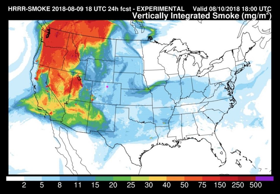
We do have a bit of smoke from the western fires (Figure 2). The upper level ridge overhead is keeping the smoke out in the Pacific Northwest. I feel bad for them, and California.

Figure 1: the water vapor satellite image from Thursday night. Reds/Oranges are dry air, greys/whites are moist air regions.

Figure 2: The HRRR (high resolution rapid refresh) model forecast of smoke at all levels for Friday noon.

The longer range forecast:

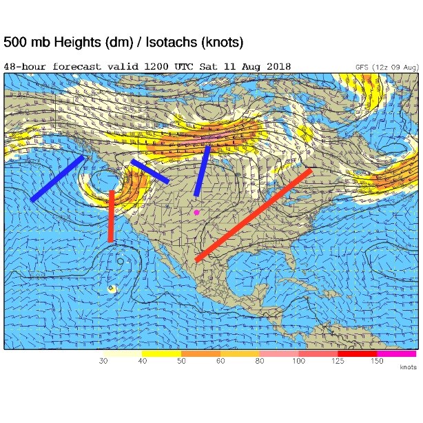
The ridge that has warmed us up and dried us out is still here through Saturday, good and strong (blue line over Colorado - Figure 3).

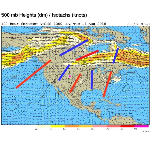
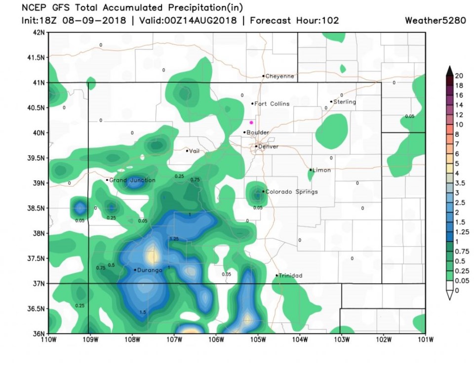
The ridge is still here on Tuesday, but a trough in the west (red line on the West Coast in Figure 4) may start to bring moisture in by Tuesday. Figure 5 is rainfall through the next five days - there is virtually no precipitation except down in the drought zone (yea!).

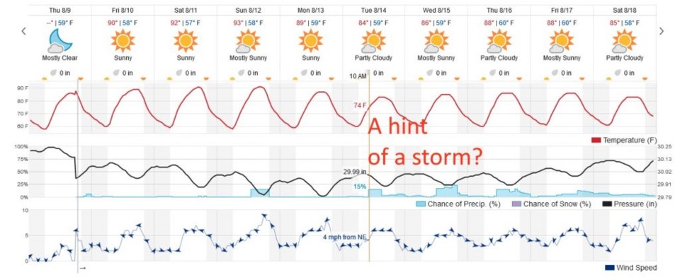
Figure 6 shows temperatures remaining right around 90° F for the next 5 days, then that western trough brings a hint of a cool down and more moisture. That IS a long way out though. You'll have to come back for more weather another day!

Figure 3: The 500mb forecast upper air analysis for Saturday AM. Pink dot is Longmont. Red lines are troughs, blue lines are ridges.

Figure 4: The 500mb forecast upper air analysis for Tuesday AM. Pink dot is Longmont. Red lines are troughs, blue lines are ridges.

Figure 5: The total accumulated precipitation between Thursday PM and Monday night (5 days out) from the GFS and weather5280.com

Figure 6: the next 10 days of the graphical forecast for Longmont, CO from weatherunderground.com

Current Weather

Mostly cloudy

Mostly cloudy

62°F

UV Index
0 Low
Pressure
29.88 Rising
Visibility
8 miles
Dewpoint
35 °F
Humidity
36%
Wind
W 3.2 mph
Gust
9 mph
Wind Chill
62 °F

Hourly Forecast

Today
7 PM
58°F
Thunderstorms
Today
8 PM
54°F
Showers
Today
9 PM
51°F
Intermittent clouds
Today
10 PM
48°F
Intermittent clouds
Today
11 PM
45°F
Intermittent clouds
Tomorrow
12 AM
44°F
Partly cloudy
Tomorrow
1 AM
42°F
Partly cloudy
Tomorrow
2 AM
41°F
Partly cloudy
Tomorrow
3 AM
40°F
Partly cloudy
Tomorrow
4 AM
39°F
Partly cloudy
Tomorrow
5 AM
38°F
Partly cloudy
Tomorrow
6 AM
37°F
Partly cloudy

7 Day Forecast

Partly sunny w/ t-storms

Sunday

64 °F

Warmer with times of clouds and sun; a thundershower in spots late this afternoon


Intermittent clouds

Sunday Night

37 °F

Partly cloudy


Partly sunny

Monday

70 °F

Partly sunny and pleasant


Intermittent clouds

Monday Night

43 °F

Partly cloudy


Mostly sunny

Tuesday

73 °F

Mostly sunny and pleasant


Intermittent clouds

Tuesday Night

41 °F

Clearing


Intermittent clouds

Wednesday

65 °F

Times of sun and clouds


Intermittent clouds

Wednesday Night

39 °F

A thundershower in spots in the evening; otherwise, partly cloudy


Rain

Thursday

53 °F

Cooler with occasional rain and drizzle; breezy in the morning


Partly cloudy

Thursday Night

32 °F

Partly cloudy


Sunrise and Sunset

Sunrise
6:03 AM
Sunset
7:53 PM

Based on AccuWeather data