Skip to content

The Next Storm/Next Snow Forecast Discussion from the Cherrywood Observatory – August 17th, 2018

This content was originally published by the Longmont Observer and is licensed under a Creative Commons license.

Forecast Discussion:

The forecast is on track.  Small cool fronts will cool us down over the weekend and give us a chance of (slightly severe) thunderstorm-type weather.  Today, we will warm to almost 90F before the next upper level trough sends a wind shift back over the state (Figure 1). As shown in this figure, there will be more storms over southern Colorado and the mountains than us today. (But a wandering storm is NOT out of the question.)

A LOT of smoke is now pouring into the state.  You might not see the thunderstorms that form except that the skies get dark-ish in the northwest (Figure 2).

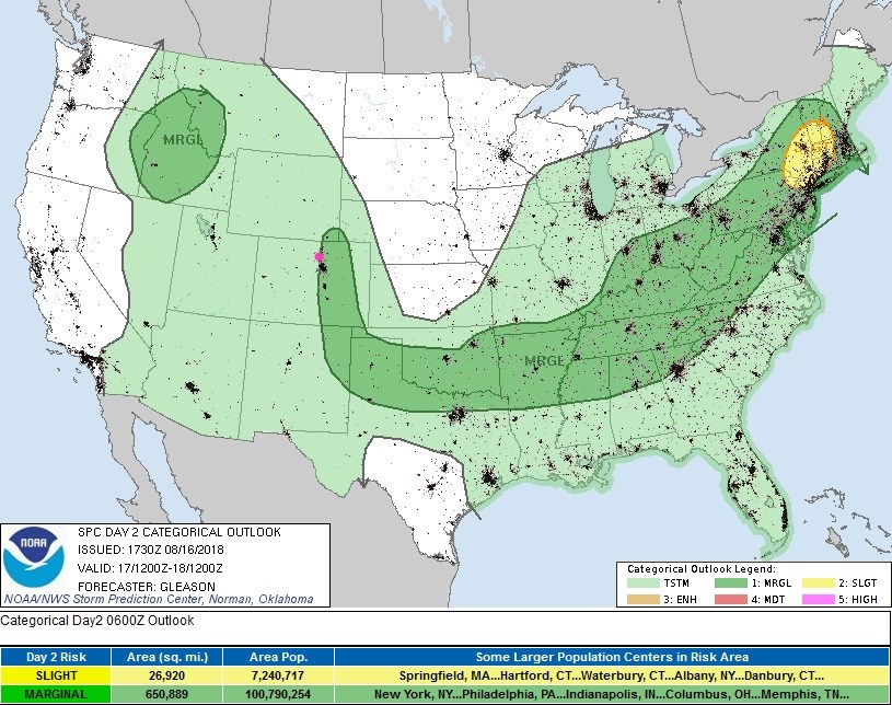
For the storms that do form around Longmont, they could be marginally severe - with hail and heavy, locally flooding rains possible (due to slow storm movement) - Figure 3.
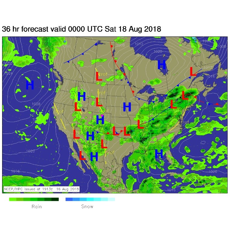
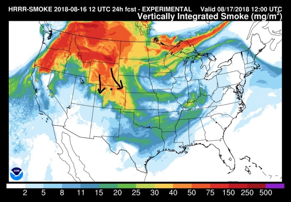
Figure 1: The forecast surface map for Friday noon. From NCEP.

Figure 2: The HRRR (high resolution rapid refresh) model forecast of smoke at all levels for Friday AM.

Figure 3: the day 2 SPC thunderstorm and severe weather forecast made Thursday (valid Friday).

The longer range forecast:

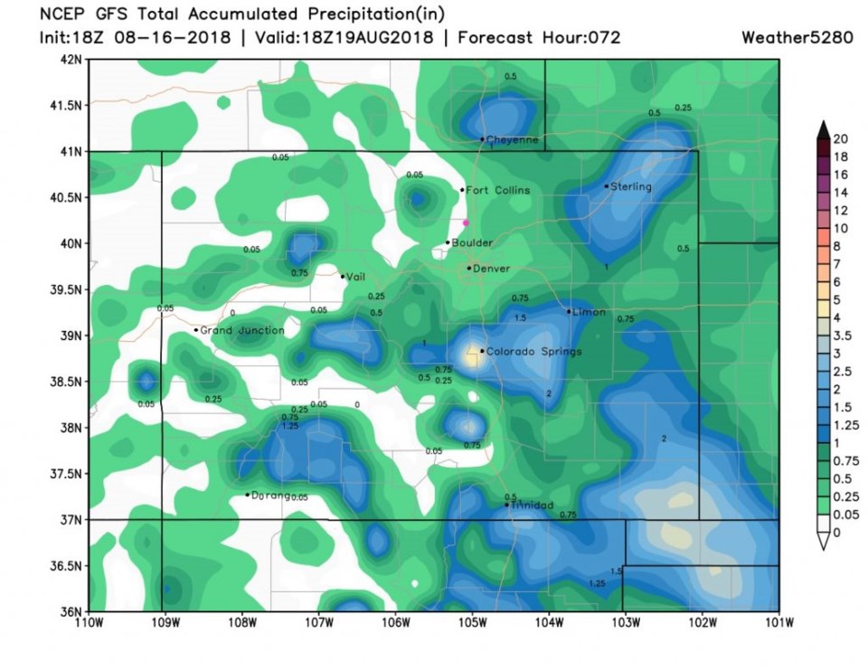
For tomorrow (Saturday) we'll get a good cool down from a front and an approaching upper level trough. This will give us another round of afternoon storms that may become severe just on the other side of I-25 (Figure 4). The next 3 days of accumulated precipitation look really spotty (Figure 5) with some spots getting 1 to 3 inches while the rest of the state pulls only a trace to a quarter inch or so.  Remember, this is not a direct indication of who will get the big rains, just an idea of what parts of the state will see the heaver storms close together and what parts will see them spread further apart. More cool air will drop temperatures to the 70'sF for a high on Sunday.  That will feel nice!

Figure 4: the day 3 SPC thunderstorm and severe weather forecast made Thursday (valid Saturday).

Figure 5: The total accumulated precipitation for the next 3 days between Friday PM and Sunday noon from the GFS and weather5280.com

Current Weather

Mostly cloudy

Mostly cloudy

57°F

UV Index
1 Low
Pressure
29.79 Steady
Visibility
8 miles
Dewpoint
40 °F
Humidity
53%
Wind
N 7.2 mph
Gust
14.7 mph
Wind Chill
57 °F

Hourly Forecast

Today
5 PM
60°F
Thunderstorms
Today
6 PM
57°F
Mostly cloudy w/ t-storms
Today
7 PM
55°F
Intermittent clouds
Today
8 PM
56°F
Thunderstorms
Today
9 PM
53°F
Cloudy
Today
10 PM
50°F
Cloudy
Today
11 PM
48°F
Cloudy
Tomorrow
12 AM
46°F
Cloudy
Tomorrow
1 AM
44°F
Cloudy
Tomorrow
2 AM
42°F
Mostly cloudy
Tomorrow
3 AM
40°F
Mostly cloudy
Tomorrow
4 AM
38°F
Mostly cloudy

7 Day Forecast

Partly sunny w/ t-storms

Wednesday

68 °F

Times of sun and clouds; a shower in spots this morning followed by a couple of thunderstorms this afternoon


Thunderstorms

Wednesday Night

35 °F

A thunderstorm this evening; otherwise, mostly cloudy


Intermittent clouds

Thursday

63 °F

A blend of sun and clouds


Mostly cloudy

Thursday Night

39 °F

Mostly cloudy


Partly sunny

Friday

64 °F

Some sun; breezy in the afternoon


Partly cloudy

Friday Night

36 °F

Partly cloudy


Partly sunny

Saturday

66 °F

Partial sunshine


Mostly clear

Saturday Night

41 °F

Clear to partly cloudy


Mostly cloudy

Sunday

78 °F

Rather cloudy and warmer; breezy in the afternoon


Mostly cloudy

Sunday Night

43 °F

Rather cloudy


Sunrise and Sunset

Sunrise
5:59 AM
Sunset
7:56 PM

Based on AccuWeather data