Skip to content

The Next Storm/Next Snow Forecast Discussion from the Cherrywood Observatory – August 24th, 2018

This content was originally published by the Longmont Observer and is licensed under a Creative Commons license.

Forecast Discussion:

The upper level ridge is taking over again. We'll see dry weather, above normal temperatures, and smoke, for many days to come.

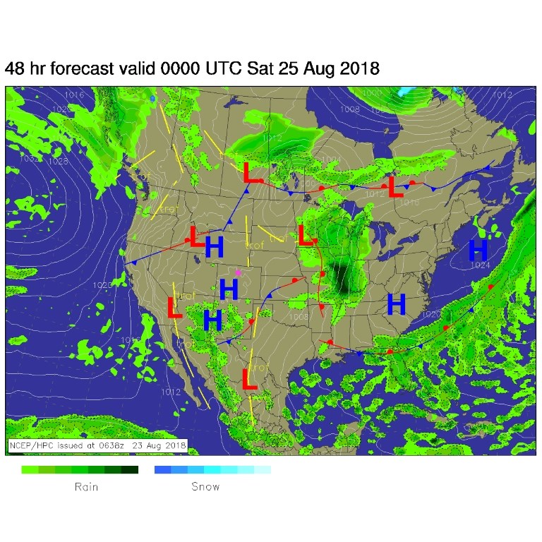
The surface map (Figure 1) shows us high and dry with a surface high pressure in place along with the upper level ridge. Together, those give us the heat and suppress the afternoon thunderstorms.

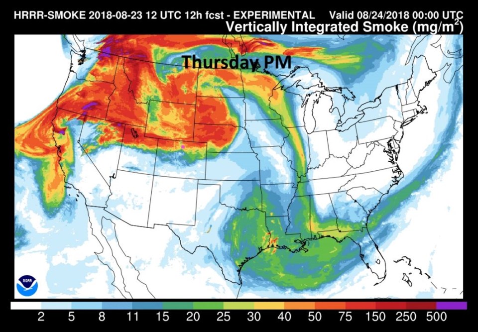
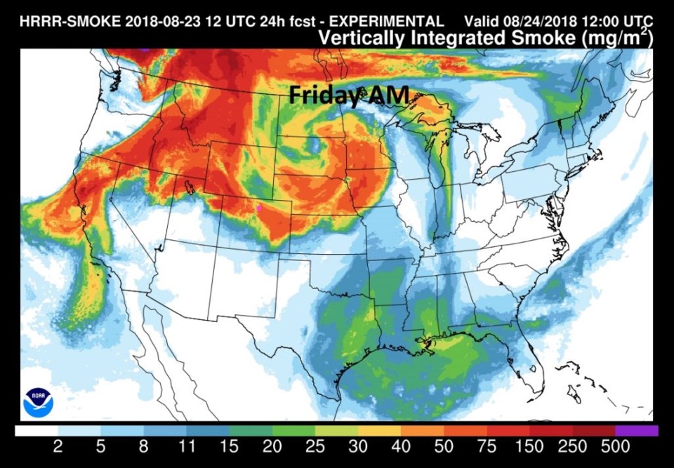
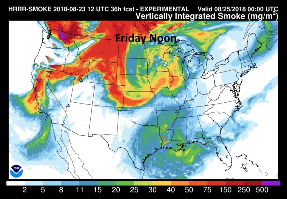
As mentioned yesterday, the west and northwest flow setting up will bring the smoke back from the western fires. Figure 2 shows it sliding down over northern Colorado last night. Figure 3 is for this morning and the smoke sinks further south into the state. Figure 3 has dense smoke around the area by noon today (with some clearing on the western slopes of Colorado). Thick smoke can shave a few degrees off the high temperature...sometimes.

Figure 1: The forecast surface map for Friday PM. From NCEP.

Figure 2: The HRRR (high resolution rapid refresh) model forecast of smoke at all levels for Thursday PM.

Figure 3: The HRRR (high resolution rapid refresh) model forecast of smoke at all levels for Friday AM.

Figure 4: The HRRR (high resolution rapid refresh) model forecast of smoke at all levels for Friday noon.

The longer range forecast:

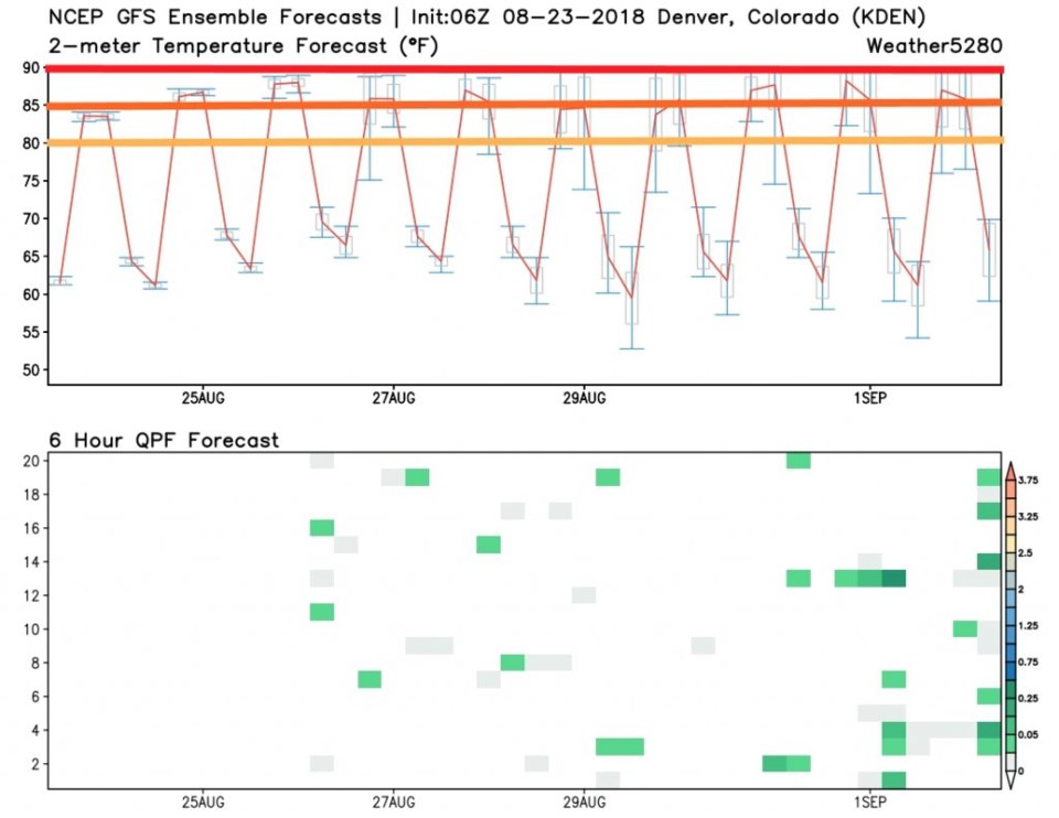
The GFS meteogram (Figure 5) shows the very small rain chances that only show up in a few runs of the model now and then. I've drawn 80° F as yellow, 85° F as orange, and 90° F as red. Each day hovers in the 85-90° F high temperature range for the next 10 days.  Our 'relief storm' possible next week is looking less and less likely.

Figure 5: the GFS temperature and ensemble precipitation meteogram forecast for the next 10 days from weather5280.com

Current Weather

Clear

Clear

59°F

UV Index
0 Low
Pressure
29.37 Falling
Visibility
8 miles
Dewpoint
33 °F
Humidity
37%
Wind
SSE 5.7 mph
Gust
12.4 mph
Wind Chill
59 °F

Hourly Forecast

Today
4 AM
52°F
Showers
Today
5 AM
50°F
Cloudy
Today
6 AM
49°F
Cloudy
Today
7 AM
47°F
Cloudy
Today
8 AM
49°F
Cloudy
Today
9 AM
51°F
Cloudy
Today
10 AM
53°F
Cloudy
Today
11 AM
54°F
Cloudy
Today
12 PM
55°F
Cloudy
Today
1 PM
55°F
Cloudy
Today
2 PM
55°F
Cloudy
Today
3 PM
55°F
Cloudy

7 Day Forecast

Intermittent clouds

Sunday

76 °F

Warmer with intervals of clouds and sunshine


Mostly cloudy w/ showers

Sunday Night

47 °F

Turning cloudy; windy late with a stray shower


Windy

Monday

55 °F

Winds gusting past 40 mph; cloudy and cooler


Windy

Monday Night

42 °F

Very windy this evening; partly cloudy


Partly sunny w/ showers

Tuesday

59 °F

A couple of showers in the morning; otherwise, windy and cool with times of clouds and sun


Partly cloudy

Tuesday Night

32 °F

Partly cloudy


Intermittent clouds

Wednesday

60 °F

Times of clouds and sun


Intermittent clouds

Wednesday Night

38 °F

Partly cloudy


Intermittent clouds

Thursday

56 °F

Cool with times of clouds and sun


Cloudy

Thursday Night

39 °F

Cloudy


Sunrise and Sunset

Sunrise
5:54 AM
Sunset
8:00 PM

Based on AccuWeather data