Skip to content

The Next Storm/Next Snow Forecast Discussion from the Cherrywood Observatory – July 4th and 5th, 2018

This content was originally published by the Longmont Observer and is licensed under a Creative Commons license.

Forecast Discussion:

Though I'm camping these first two weeks of July, I got enough bandwidth and time to put together a more normal discussion. This post will cover the 4th and 5th.

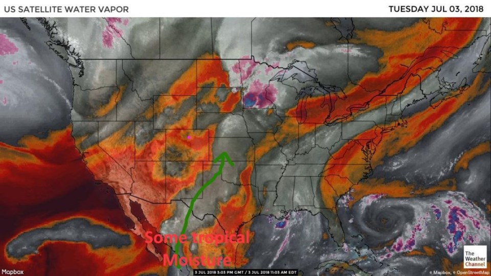
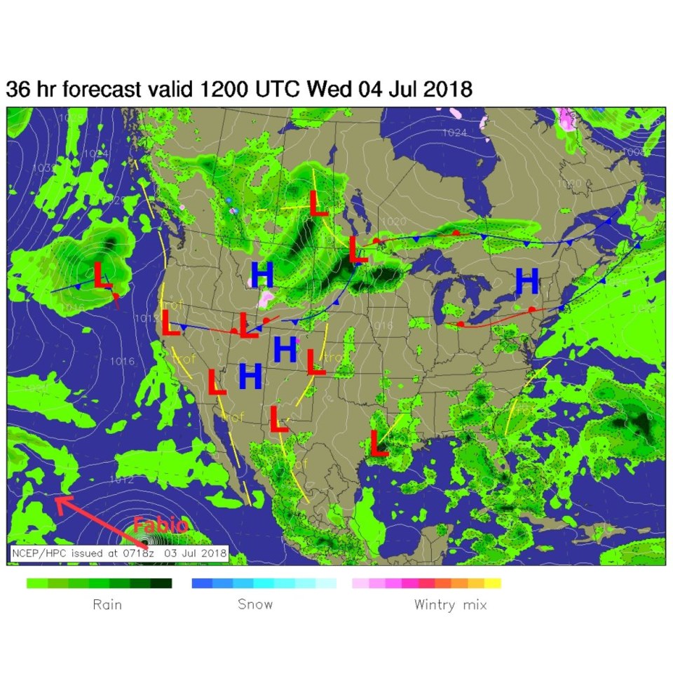
There is a trickle of moisture coming up from the tropics that will interact with the next storm Wednesday night and Thursday (Figure 1). The forecast weather map for Wednesday morning shows the cold front that will push down into the state about as far as the Palmer Divide Wednesday into Thursday (Figure 2).

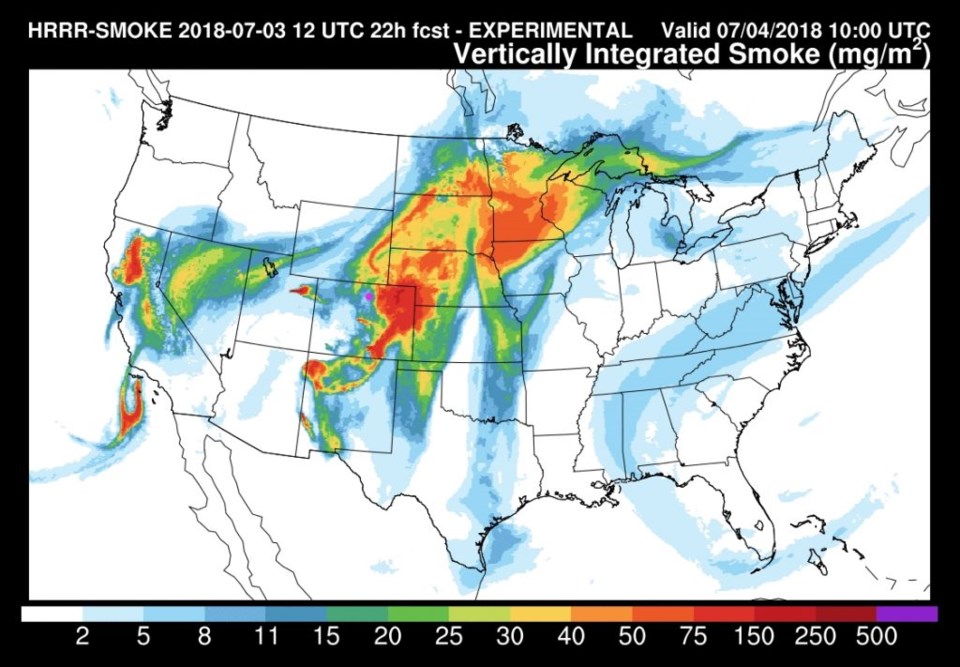
Tragically, fires are getting the upper hand in places in the west again and the forecast smoke map for later Wednesday shows a complex pattern of smoke at different levels around the state (Figure 3).

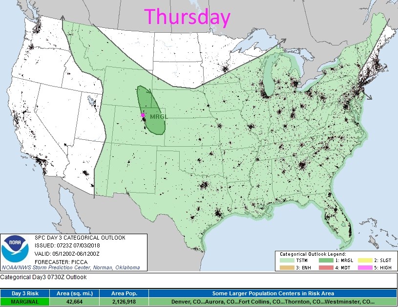
For Thursday, the front will be in place, some moisture will be pushed back to the west behind the front - and we'll see a chance of severe weather.  The severe risk will be marginal (1 on a scale of 1-5) for a few isolated cells that may produce large hail and strong damaging winds by evening (Figure 4).

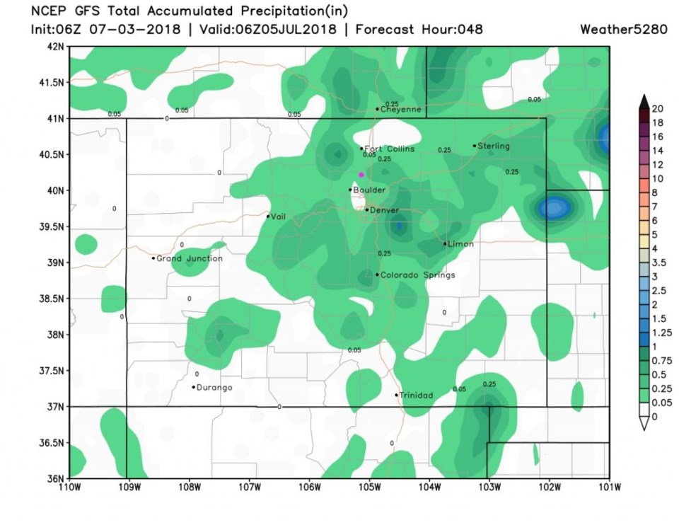
The amount of rain across the state by Thursday afternoon will be spotty and based on where thunderstorms form. Some places will see nothing, while others may pull a quarter of an inch or more. Storm motion will be slow since the upper level steering winds under the Western ridge are going to be fairly light (Figure 5).

Figure 1: the water vapor satellite image from Tuesday AM. Reds/Oranges are dry air, greys/whites are moist air regions.

Figure 2: The forecast surface map for Wednesday morning. From NCEP.

Figure 3: The HRRR model forecast for smoke at all levels for Wednesday midday. From NOAA.gov

Figure 4: the day 2 SPC thunderstorm and severe weather forecast made Tuesday (valid Thursday).

Figure 5: total precipitation from the GFS between Tuesday midday and Thursday AM and weather5280.com. (the next 48 hours)

The longer range forecast:

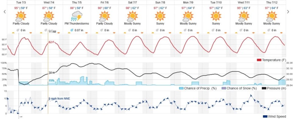
Longmont cools to the upper 80's Wednesday and Thursday, then climb to the upper 90's F (it will be 100+F on the eastern planes nearby). A few afternoon storms may wander out of the mountains most days.  It is a fairly quiet summer pattern again!

Figure 6: the next 10 days of the graphical forecast for Longmont, CO from weatherunderground.com

Current Weather

Cloudy

Cloudy

39°F

UV Index
0 Low
Pressure
29.93 Steady
Visibility
7 miles
Dewpoint
38 °F
Humidity
94%
Wind
N 1.1 mph
Gust
2.2 mph
Wind Chill
39 °F

Hourly Forecast

Today
2 AM
39°F
Rain
Today
3 AM
39°F
Rain
Today
4 AM
38°F
Cloudy
Today
5 AM
37°F
Cloudy
Today
6 AM
37°F
Cloudy
Today
7 AM
38°F
Cloudy
Today
8 AM
40°F
Cloudy
Today
9 AM
44°F
Cloudy
Today
10 AM
47°F
Mostly cloudy
Today
11 AM
50°F
Mostly cloudy
Today
12 PM
53°F
Mostly cloudy
Today
1 PM
56°F
Mostly cloudy

7 Day Forecast

Rain and snow

Saturday

43 °F

Chilly with a mix of snow and rain; travel in the foothills and mountains will be slippery due to snow


Rain and snow

Saturday Night

37 °F

Cloudy; rain and drizzle in the evening followed by a bit of snow and rain at times late; travel in the foothills and mountains will be slippery due to snow


Thunderstorms

Sunday

61 °F

Mostly cloudy and warmer; a thundershower in spots this afternoon


Partly cloudy w/ t-storms

Sunday Night

37 °F

A thunderstorm in spots this evening; otherwise, partly cloudy


Partly sunny

Monday

71 °F

Partly sunny, pleasant and warmer


Intermittent clouds

Monday Night

42 °F

Partly cloudy


Mostly sunny

Tuesday

73 °F

Mostly sunny and pleasant


Mostly cloudy

Tuesday Night

43 °F

Mostly cloudy


Intermittent clouds

Wednesday

65 °F

Times of sun and clouds with a passing shower in the afternoon


Rain

Wednesday Night

42 °F

Overcast; a couple of evening showers followed by rain and drizzle late


Sunrise and Sunset

Sunrise
6:04 AM
Sunset
7:52 PM

Based on AccuWeather data