Skip to content

The Next Storm/Next Snow Forecast Discussion from the Cherrywood Observatory – June 13, 2018

This content was originally published by the Longmont Observer and is licensed under a Creative Commons license.

Forecast Discussion:

We have just about everything to discuss today- except for snow.

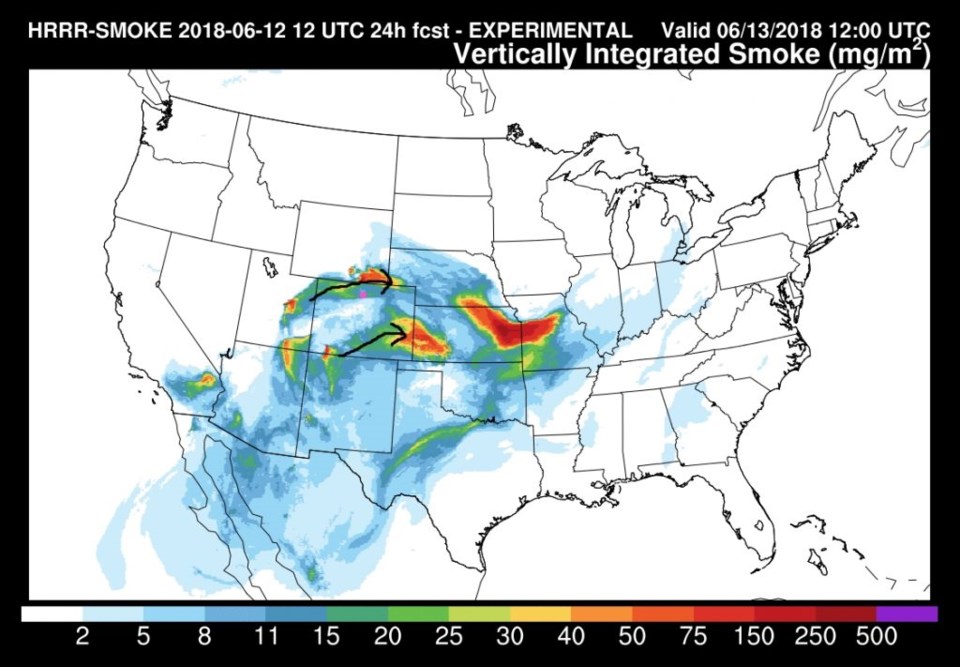
First, the fires of the western U.S. are still a growing problem with smoke levels increasing on west-southwest flow.  Figure 1 shows the Utah smoke source making it to Longmont.  The fires down south are adding a lot of smoke to the Great Plains.

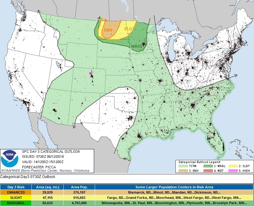
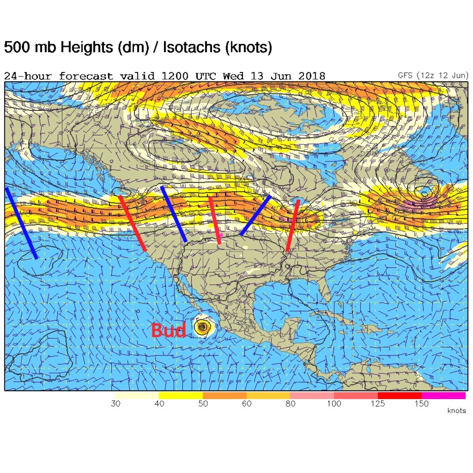
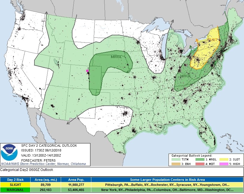
Next, the zonal (west to east) jet stream flow still has small ripples (short waves) traveling down the stream.  One of those is over Colorado today with a weak easterly flow at the surface bringing some more moisture into our eastern Plains (Figure 2).  From these features, we have a chance of thunderstorms across the entire state (lighting is always a problem when fire danger is high!) and a marginal risk of severe weather returns backing up to I-25. Large hail and strong downdraft winds are the risk just to the east of us (unless the risk is expanded a few miles westward overnight); Figure 3.

Figure 1: The HRRR model forecast for smoke at all levels for Wednesday AM. From NOAA.gov

Figure 2: The 500mb upper air analysis forecast from the GFS for Wednesday AM. Red lines are troughs, blue lines are ridges. Pink dot is Longmont.

Figure 3: the day 2 SPC thunderstorm and severe weather forecast made Tuesday (valid Wednesday).

The longer range forecast:

Tomorrow, the ripple is past and a moisture levels drop a bit.  Our risk of severe weather is absent from the state.  Just general afternoon thunderstorms are expected in spots (Figure 4).

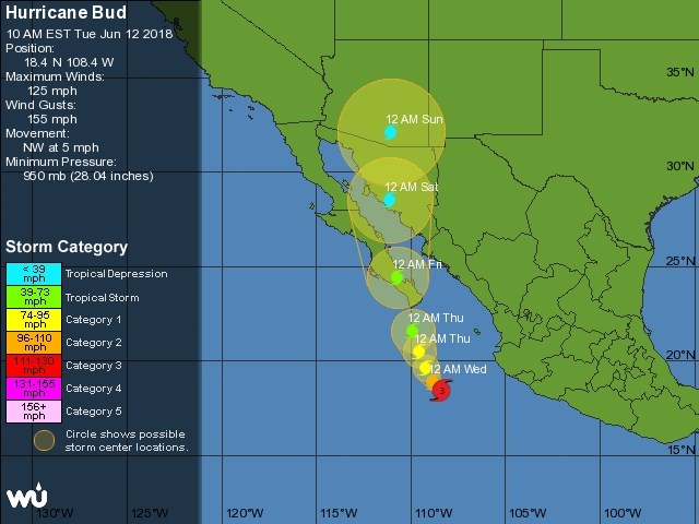
That changes this weekend.  Hurricane Bud (still a category 3 storm) is headed our way via southern Arizona (as a tropical depression); Figure 5.

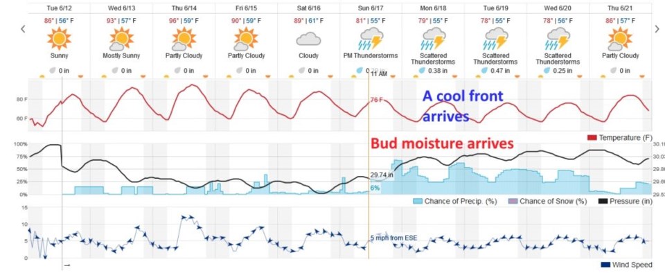
Figure 6 shows the cool down (out of the 90'sF again) coming for the weekend as moisture levels increase.  Moisture from Bud arrives and storm chances increase dramatically Sunday.  A cool front pushes down, in the new week, further kicking up showers and strengthening up-slope moist air flow. If this model is correct (from weatherunderground.com) Longmont receives 1 1/3rd inches of rain before Thursday next week.  Keep hoping!  Let's get some help putting fires out, from above.

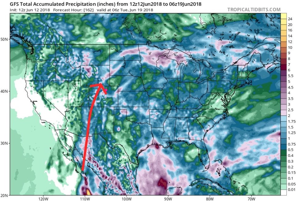
Figure 7 is the total precipitation thought Monday night.  One can see a possible track of much of the moisture from Bud (from the GFS).

Figure 4: the day 3 SPC thunderstorm and severe weather forecast made Tuesday (valid Thursday).

Figure 5: The National Hurricane center prediction for the future 5 day position and strength of hurricane Bud. From weatherunderground.com

Figure 6: the total 10 days of the graphical forecast for Longmont, CO from weatherunderground.com

Figure 7: the total precipitation between Tuesday PM and Monday PM from the GFS and tropicaltidbits.com. Red arrow is approximate moisture flow from tropical system Bud.

Current Weather

Cloudy

Cloudy

38°F

UV Index
0 Low
Pressure
29.91 Steady
Visibility
8 miles
Dewpoint
37 °F
Humidity
96%
Wind
NW 0.5 mph
Gust
1.7 mph
Wind Chill
38 °F

Hourly Forecast

Today
6 AM
37°F
Showers
Today
7 AM
38°F
Rain and snow
Today
8 AM
39°F
Cloudy
Today
9 AM
42°F
Cloudy
Today
10 AM
46°F
Mostly cloudy
Today
11 AM
49°F
Mostly cloudy
Today
12 PM
52°F
Cloudy
Today
1 PM
55°F
Cloudy
Today
2 PM
57°F
Cloudy
Today
3 PM
58°F
Thunderstorms
Today
4 PM
59°F
Mostly cloudy
Today
5 PM
61°F
Mostly cloudy

7 Day Forecast

Thunderstorms

Sunday

61 °F

Mostly cloudy and warmer; a thundershower in spots this afternoon


Partly cloudy w/ t-storms

Sunday Night

37 °F

An evening thunderstorm in parts of the area; otherwise, partly cloudy


Partly sunny

Monday

70 °F

Partly sunny, pleasant and warmer


Intermittent clouds

Monday Night

43 °F

Partly cloudy


Mostly sunny

Tuesday

73 °F

Mostly sunny and pleasant


Mostly cloudy

Tuesday Night

41 °F

Mostly cloudy


Intermittent clouds

Wednesday

65 °F

Times of sun and clouds with a passing shower in the afternoon


Intermittent clouds

Wednesday Night

39 °F

A thundershower in spots in the evening; otherwise, partly cloudy


Rain

Thursday

49 °F

Chilly with rain and drizzle


Partly cloudy

Thursday Night

28 °F

Partly cloudy


Sunrise and Sunset

Sunrise
6:03 AM
Sunset
7:53 PM

Based on AccuWeather data