Skip to content

The Next Storm/Next Snow Forecast Discussion from the Cherrywood Observatory – June 14, 2018

This content was originally published by the Longmont Observer and is licensed under a Creative Commons license.

Forecast Discussion:

As the heat cranks up (we'll talk about that in a moment) - smoke continues to be a problem. There are a number fires out across the southwest and they are making the sky hazy. We are missing the worst of it today (Figure 1).

Moisture is slowly increasing (and largely, it would be happening even if hurricane Bud hadn't been a 'thing'). Figure 2 shows the water vapor satellite image and there is Pacific moisture, gulf of California moisture, and Gulf of Mexico moisture finding its way towards us. We had severe thunderstorms out in the eastern Colorado (green arrows) fueled by this moisture.

Figure 3 shows that, before the weather changes this weekend, we approach 100F again. There will be a chance of afternoon thunderstorms around the state, but nothing severe is expected today.

Figure 1: The HRRR model forecast for smoke at all levels for Thursday afternoon. From NOAA.gov

Figure 2: the water vapor satellite image from Wednesday PM. Reds/Oranges are dry air, greys/whites are moist air regions.

Figure 3: Forecast temperatures around 6pm Thursday.

The longer range forecast:

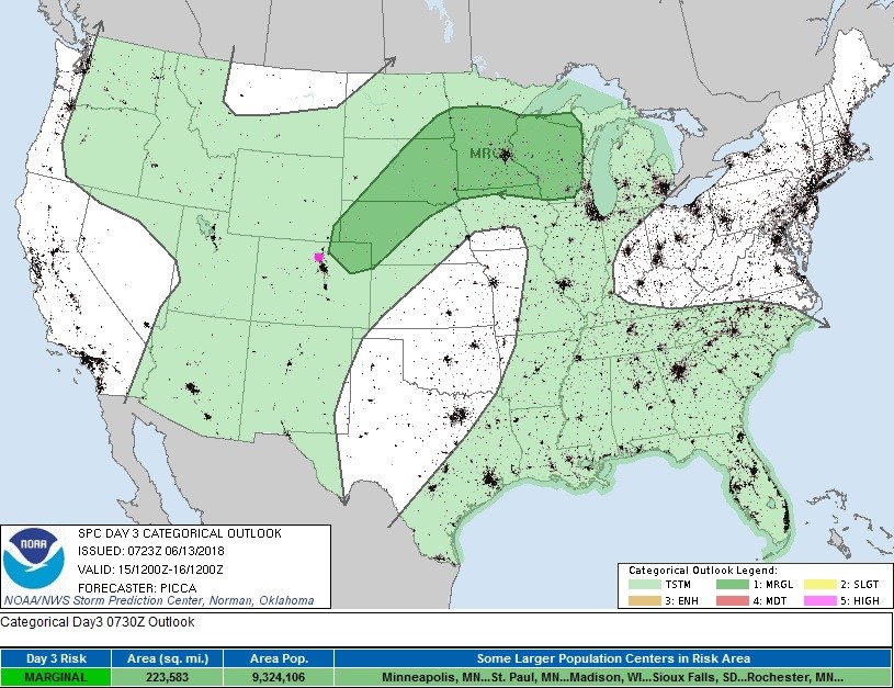
Tomorrow, the change begins.  A front pushes into the state.  That, plus the better moisture around, will make marginally severe weather conditions possible for NE Colorado.  This doesn't include Longmont at this time (Figure 4).

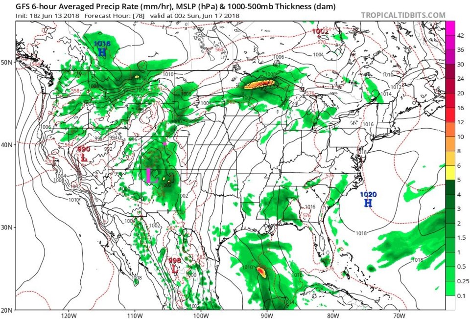
The big news is the moisture from Bud.  Bud's forecast is not towards southeast AZ (as it was yesterday) but is now towards extreme eastern New Mexico on a path towards Colorado (Figure 5). This is the circulation center. The GFS has the low center further north (northern New Mexico) for Saturday evening, with the bulk of moisture is ahead of the former tropical system's center up into Colorado (Figure 6).

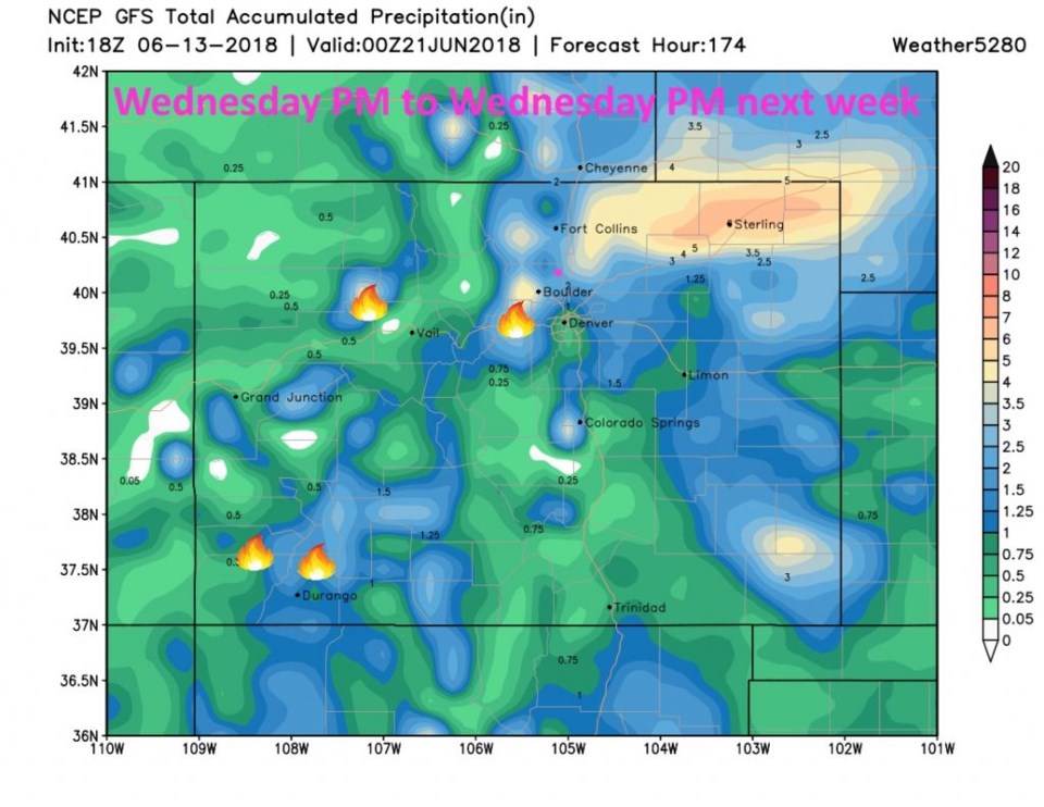
Figure 7 is a (probably over zealous) estimation of the rainfall for the next week. I've added the approximate locations of the four big fires. IF this verifies, this is over an inch of rainfall for all of the hot spots. The extreme rainfall in NE Colorado seems to come from a big thunderstorm complex, along a front, that invades the state on Monday into Tuesday. We'll keep an eye on all of it. Longmont seems to pick up around 1 1/2 inches of rainfall over the next 8 days, from the GFS.

Figure 4: the day 3 SPC thunderstorm and severe weather forecast made Wednesday (valid Friday ).

Figure 5: The National Hurricane center prediction for the future 5 day position and strength of hurricane Bud. From weatherunderground.com

Figure 6: The future weather map from the GFS and tropicaltidbits.com valid Saturday PM.

Figure 7: total precipitation from the GFS between Wednesday and next Wednesday. and weather5280.com.

Current Weather

Mostly cloudy

Mostly cloudy

38°F

UV Index
0 Low
Pressure
29.96 Steady
Visibility
8 miles
Dewpoint
35 °F
Humidity
89%
Wind
W 1.7 mph
Gust
3.3 mph
Wind Chill
38 °F

Hourly Forecast

Today
7 AM
40°F
Partly sunny
Today
8 AM
48°F
Partly sunny
Today
9 AM
54°F
Partly sunny
Today
10 AM
58°F
Partly sunny
Today
11 AM
62°F
Partly sunny
Today
12 PM
65°F
Partly sunny
Today
1 PM
67°F
Partly sunny
Today
2 PM
68°F
Partly sunny
Today
3 PM
69°F
Partly sunny
Today
4 PM
70°F
Partly sunny
Today
5 PM
69°F
Partly sunny
Today
6 PM
67°F
Partly sunny

7 Day Forecast

Partly sunny

Monday

70 °F

Partly sunny and pleasant


Intermittent clouds

Monday Night

43 °F

Partly cloudy


Mostly sunny

Tuesday

73 °F

Mostly sunny; windy in the morning, then pleasant in the afternoon


Intermittent clouds

Tuesday Night

43 °F

Clearing


Intermittent clouds

Wednesday

65 °F

Periods of clouds and sun; breezy in the afternoon


Intermittent clouds

Wednesday Night

39 °F

An evening thundershower in spots; otherwise, partly cloudy


Intermittent clouds

Thursday

57 °F

Clouds and sun, becoming windier and cooler with a shower in spots


Mostly clear

Thursday Night

32 °F

Mainly clear


Mostly sunny

Friday

71 °F

Mostly sunny, pleasant and warmer


Partly cloudy

Friday Night

36 °F

Partly cloudy


Sunrise and Sunset

Sunrise
6:02 AM
Sunset
7:54 PM

Based on AccuWeather data